SlideShare ist ein Scribd-Unternehmen logo
1 von 1
Downloaden Sie, um offline zu lesen
PILOT TOOL spatial analysis
for investment targeting
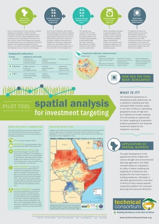
The Technical Consortium is
developing a pilot spatial tool, as
a resilience modeling tool that
will assist IGAD member states
in the Horn of Africa in identifying
geographic areas of high and
low resilience to known hazards.
This will provide an opportunity
for better targeting of investment
projects proposed in the drylands
investment plans for the
respective countries.
WHAT IS IT?
HOW HAS THE TOOL
BEEN DEVELOPED?
Drought hotspots (likelihood of occurrence and lack of resilience)
is a product of likelihood of drought occuring and susceptibility to
drought divided by the inverse of time to revover after a drought.
Relative resilience to drought: Drought hotspots in the Horn of Africa
Data inventory
undertaken across
Horn of Africa
165 system indicators
synthesised from
baseline data
Indicators weighted
for use in the
spatial tool
Composite indicators
developed for each
system
Spatial output,
indicating an area’s
relative resilience
The spatial tool analyzes the
resilience layers for each of the
administration districts that
are submitted in the query and
produces a summary table
containing information on the area’s
susceptibility, time to recover and
overall resilience. The output is then
illustrated as a regional map. (See
below for more details.)
The pilot development of the
spatial tool will be trialed with
various drought and environmental
planning agencies in the IGAD
member states to understand
its utility in better enabling the
targeting of investments and
projects for the most impact in
building resilience. Ultimately, it
will allow governments in the Horn
of Africa to host a sector-specific
investment platform for improved
planning and resource allocation.
Over a six-month period, a robust scoping for available
datasets was undertaken, entailing extensive
consultation with agencies, NGOs and governments
in the Horn of Africa to collate available information
on data sources that best represent resilience in the
Horn of Africa. A total of 452 datasets were acquired
and standardized so as to be comparable and scalable
between values representing highest and lowest
resilience. The systems framing these baseline datasets
are designated as social, economic and ecological.
From the pool of datasets, 165 indicators
were selected that best represent resilience
in social, ecological and economic systems,
based largely on expert opinion and on the
following underlying criteria: relevance to
the region’s resilience; data quality and
availability of the data on a regional and
national level. The indicators were then
divided amongst the three systems: social
(51), economic (73) and ecological (41).
Careful consideration was given
in assigning weights to each
indicator in order to compose
an overall index of resilience.
Each indicator was weighted
using an ArcGIS Model
Builder, which allows for easy
changing of weightings at two
classification levels for future
sensitivity analysis.
The indicators were
combined into composite
indicators, in order to allow
for multiple overlays in line
with GIS mapping capability.
An ESRI Model Builder
was used to assimilate
these data into composite
indicators for each system,
as per the tables below:
SYSTEM COMPOSITE INDICATORS
ECONOMIC ● Trade access
● Financial services
● Economic shocks
● Financial conditions
● Wealth
● Income diversification
● Infrastructure
ECOLOGICAL ● Water resources
● Land use
● Ecological services
● Climate
● Natural resource
shocks
● Population
density and per
capita resources
SOCIAL ● Land use support
● Community support
● Information
● Health
● Education
● Governance
● Social shocks
Composite indicators
AREA of the administration district
POPULATION of the administration district
(calculated from AfriPOP 2010 adjusted UN)
SUSCEPTIBILIT Y/IMPACT: mean
value of the ecological or environmental
system layer (as indicated by the weighting of
its ecological indicators). Low impact equates
to high resilience, while high values of impact
equates to low resilience, at the time of the
environmental shock. Values are relative; they
are not interpreted in any other way.
TIME TO RECOVER: The mean value
of the socio-economic systems layer (as
indicated by the weighting of its social and
economic indicators) is inverted so that
high socio-economic capacity represents an
expected shorter time to recover following a
shock. Short recovery time values equate
to a high resilience, while long recovery time
values equate to low resilience. Values are
relative; they are not interpreted to actual
time.
OVERALL RESILIENCE: calculated by
combining susceptibility with measures of
recovery time (this is computed as socio-
economic capacity for recovery divided by
environmental-sensitivity or susceptibility
to the shock). Areas with high capacity for
quick recovery and low susceptibility to the
shock are accorded highest resilience; while
areas poor in capacity for recovery and highly
susceptible to the shock are accorded lowest
resilience.
APPLICATION OF
SPATIAL OUTPUTS
SPATIAL TOOL OUTPUT 1: SUMMARY TABLE
TIME TO RECOVER:
Building Resilience in the Horn of Africa
For any queries, please contact Dr Katie Downie, Coordinator of the Technical Consortium for Building Resilience in the Horn of Africa.
Direct line: +254 20 422 3066 Mobile: +254 708 985 664 Email: k.downie@cgiar.org Skype: kdowniengini www.technicalconsortium.org
SPATIAL TOOL OUTPUT 2: MAP
A regional map is produced showing locations where environmental shocks are expected
to have a higher impact and affected communities will take a long time to recover
(highlighted in red), and areas where shocks have a lower impact and communities will
be quicker to recover (highlighted in blue).
The spatial tool analyzes the resilience layers for each
of the administration districts that are submitted in
the query and produces a summary table containing
the following information:
• Lights at night infrastructure
• Travel time to the nearest
city
• Road and rail infrastructure
• Distance to the nearest port
• Communication (internet,
cell phones, land lines, etc.)
• Agricultural inputs
• % land under irrigation
• Irrigation potential
• Electrical infrastructure
• Distance to nearest airport
• Distance to nearest market
• Crop storage facilities
• Air infrastructure
Composite indicator: Infrastructure
INDICATORSSPATIAL MAP
SOCIAL
ECOLOGICAL
ECONOMIC • Lights at night infrastructure
• Travel time to the nearest
city
• Road and rail infrastructure
• Distance to the nearest port

Weitere ähnliche Inhalte

Was ist angesagt?

geo information ppt in disaster management
geo information ppt in disaster managementgeo information ppt in disaster management
geo information ppt in disaster managementKirpaldumaniya
 
Pan_European and pan-African Early Warning on Floods and Droughts: From the E...
Pan_European and pan-African Early Warning on Floods and Droughts: From the E...Pan_European and pan-African Early Warning on Floods and Droughts: From the E...
Pan_European and pan-African Early Warning on Floods and Droughts: From the E...Global Risk Forum GRFDavos
 
NATIONAL REMOTE SENSING AGENCY (NRSA)
NATIONAL REMOTE SENSING AGENCY (NRSA)NATIONAL REMOTE SENSING AGENCY (NRSA)
NATIONAL REMOTE SENSING AGENCY (NRSA)kvn virinchi
 
Application of gis in natural disaster management
Application of gis in natural disaster managementApplication of gis in natural disaster management
Application of gis in natural disaster managementMuhammad Sajjad
 
Programme on Climate Information for Resilient Development in Africa
Programme on Climate Information for Resilient Development in AfricaProgramme on Climate Information for Resilient Development in Africa
Programme on Climate Information for Resilient Development in AfricaUNDP Climate
 
Session 1.1.4. Applying Climate Services for NAP development and implementation
Session 1.1.4. Applying Climate Services for NAP development and implementationSession 1.1.4. Applying Climate Services for NAP development and implementation
Session 1.1.4. Applying Climate Services for NAP development and implementationNAP Events
 
Using GIS Technology to Improve Emergency Management
Using GIS Technology to Improve Emergency ManagementUsing GIS Technology to Improve Emergency Management
Using GIS Technology to Improve Emergency ManagementAmberStacy
 
National Adaptation Plan Zambia Country Experience
National Adaptation Plan Zambia Country ExperienceNational Adaptation Plan Zambia Country Experience
National Adaptation Plan Zambia Country ExperienceUNDP Climate
 
15328Crawford, Integrated Systems 20150528
15328Crawford, Integrated Systems 2015052815328Crawford, Integrated Systems 20150528
15328Crawford, Integrated Systems 20150528Jeffrey Crawford
 
Geospatial tools to guide targeting of technologies
Geospatial tools to guide targeting of technologiesGeospatial tools to guide targeting of technologies
Geospatial tools to guide targeting of technologiesafrica-rising
 
Natural Hazards & ROLE of satellite remote sensing
Natural Hazards & ROLE of satellite remote sensingNatural Hazards & ROLE of satellite remote sensing
Natural Hazards & ROLE of satellite remote sensingABU UMEER BANBHAN
 
Digital Land Record Management System KP, Pakistan
Digital Land Record Management System KP, PakistanDigital Land Record Management System KP, Pakistan
Digital Land Record Management System KP, PakistanHaris Khan
 
Application of Remote Sensing & GIS in Disaster Management
Application of Remote Sensing & GIS in Disaster ManagementApplication of Remote Sensing & GIS in Disaster Management
Application of Remote Sensing & GIS in Disaster ManagementAjayPatro
 

Was ist angesagt? (19)

geo information ppt in disaster management
geo information ppt in disaster managementgeo information ppt in disaster management
geo information ppt in disaster management
 
Pan_European and pan-African Early Warning on Floods and Droughts: From the E...
Pan_European and pan-African Early Warning on Floods and Droughts: From the E...Pan_European and pan-African Early Warning on Floods and Droughts: From the E...
Pan_European and pan-African Early Warning on Floods and Droughts: From the E...
 
NATIONAL REMOTE SENSING AGENCY (NRSA)
NATIONAL REMOTE SENSING AGENCY (NRSA)NATIONAL REMOTE SENSING AGENCY (NRSA)
NATIONAL REMOTE SENSING AGENCY (NRSA)
 
Application of gis in natural disaster management
Application of gis in natural disaster managementApplication of gis in natural disaster management
Application of gis in natural disaster management
 
Programme on Climate Information for Resilient Development in Africa
Programme on Climate Information for Resilient Development in AfricaProgramme on Climate Information for Resilient Development in Africa
Programme on Climate Information for Resilient Development in Africa
 
GIS IN DISASTER MANAGEMENT
GIS IN DISASTER MANAGEMENTGIS IN DISASTER MANAGEMENT
GIS IN DISASTER MANAGEMENT
 
Session 1.1.4. Applying Climate Services for NAP development and implementation
Session 1.1.4. Applying Climate Services for NAP development and implementationSession 1.1.4. Applying Climate Services for NAP development and implementation
Session 1.1.4. Applying Climate Services for NAP development and implementation
 
Using GIS Technology to Improve Emergency Management
Using GIS Technology to Improve Emergency ManagementUsing GIS Technology to Improve Emergency Management
Using GIS Technology to Improve Emergency Management
 
GIS For Wildfire
GIS For WildfireGIS For Wildfire
GIS For Wildfire
 
MODELLING THE IMPACT OF FLOODING USING GEOGRAPHIC INFORMATION SYSTEM AND REMO...
MODELLING THE IMPACT OF FLOODING USING GEOGRAPHIC INFORMATION SYSTEM AND REMO...MODELLING THE IMPACT OF FLOODING USING GEOGRAPHIC INFORMATION SYSTEM AND REMO...
MODELLING THE IMPACT OF FLOODING USING GEOGRAPHIC INFORMATION SYSTEM AND REMO...
 
National Adaptation Plan Zambia Country Experience
National Adaptation Plan Zambia Country ExperienceNational Adaptation Plan Zambia Country Experience
National Adaptation Plan Zambia Country Experience
 
15328Crawford, Integrated Systems 20150528
15328Crawford, Integrated Systems 2015052815328Crawford, Integrated Systems 20150528
15328Crawford, Integrated Systems 20150528
 
Geospatial tools to guide targeting of technologies
Geospatial tools to guide targeting of technologiesGeospatial tools to guide targeting of technologies
Geospatial tools to guide targeting of technologies
 
Natural Hazards & ROLE of satellite remote sensing
Natural Hazards & ROLE of satellite remote sensingNatural Hazards & ROLE of satellite remote sensing
Natural Hazards & ROLE of satellite remote sensing
 
Role of RS & GIS; gis in disaster management prepared by er. bishnu khatri
Role of RS & GIS; gis in disaster management prepared by er. bishnu khatriRole of RS & GIS; gis in disaster management prepared by er. bishnu khatri
Role of RS & GIS; gis in disaster management prepared by er. bishnu khatri
 
GIS in emergency management
GIS in emergency managementGIS in emergency management
GIS in emergency management
 
Using IMPLAN for Conservation Economic Impacts
Using IMPLAN for Conservation Economic ImpactsUsing IMPLAN for Conservation Economic Impacts
Using IMPLAN for Conservation Economic Impacts
 
Digital Land Record Management System KP, Pakistan
Digital Land Record Management System KP, PakistanDigital Land Record Management System KP, Pakistan
Digital Land Record Management System KP, Pakistan
 
Application of Remote Sensing & GIS in Disaster Management
Application of Remote Sensing & GIS in Disaster ManagementApplication of Remote Sensing & GIS in Disaster Management
Application of Remote Sensing & GIS in Disaster Management
 

Andere mochten auch

Highlights from impact assessments ILRI and Livestock and Fish CRP
Highlights from impact assessments ILRI and Livestock and Fish CRP Highlights from impact assessments ILRI and Livestock and Fish CRP
Highlights from impact assessments ILRI and Livestock and Fish CRP ILRI
 
Food safety related to pork consumption: A rapid integrated assessment in Hun...
Food safety related to pork consumption: A rapid integrated assessment in Hun...Food safety related to pork consumption: A rapid integrated assessment in Hun...
Food safety related to pork consumption: A rapid integrated assessment in Hun...ILRI
 
Risk assessment and health research in Vietnam: A first special issue of the ...
Risk assessment and health research in Vietnam: A first special issue of the ...Risk assessment and health research in Vietnam: A first special issue of the ...
Risk assessment and health research in Vietnam: A first special issue of the ...ILRI
 
Integrating gender equity and empowerment in the Dairy Goat and Root Crop Pro...
Integrating gender equity and empowerment in the Dairy Goat and Root Crop Pro...Integrating gender equity and empowerment in the Dairy Goat and Root Crop Pro...
Integrating gender equity and empowerment in the Dairy Goat and Root Crop Pro...ILRI
 
ILRI in East and Southeast Asia: Summary of current profile and emerging prio...
ILRI in East and Southeast Asia: Summary of current profile and emerging prio...ILRI in East and Southeast Asia: Summary of current profile and emerging prio...
ILRI in East and Southeast Asia: Summary of current profile and emerging prio...ILRI
 
What attributes do Uganda pig traders consider to maximize returns and utilit...
What attributes do Uganda pig traders consider to maximize returns and utilit...What attributes do Uganda pig traders consider to maximize returns and utilit...
What attributes do Uganda pig traders consider to maximize returns and utilit...ILRI
 
Accelerating CBPP research towards a better vaccine through the application o...
Accelerating CBPP research towards a better vaccine through the application o...Accelerating CBPP research towards a better vaccine through the application o...
Accelerating CBPP research towards a better vaccine through the application o...ILRI
 
Approaches in livestock animal health research and management
Approaches in livestock animal health research and managementApproaches in livestock animal health research and management
Approaches in livestock animal health research and managementILRI
 

Andere mochten auch (8)

Highlights from impact assessments ILRI and Livestock and Fish CRP
Highlights from impact assessments ILRI and Livestock and Fish CRP Highlights from impact assessments ILRI and Livestock and Fish CRP
Highlights from impact assessments ILRI and Livestock and Fish CRP
 
Food safety related to pork consumption: A rapid integrated assessment in Hun...
Food safety related to pork consumption: A rapid integrated assessment in Hun...Food safety related to pork consumption: A rapid integrated assessment in Hun...
Food safety related to pork consumption: A rapid integrated assessment in Hun...
 
Risk assessment and health research in Vietnam: A first special issue of the ...
Risk assessment and health research in Vietnam: A first special issue of the ...Risk assessment and health research in Vietnam: A first special issue of the ...
Risk assessment and health research in Vietnam: A first special issue of the ...
 
Integrating gender equity and empowerment in the Dairy Goat and Root Crop Pro...
Integrating gender equity and empowerment in the Dairy Goat and Root Crop Pro...Integrating gender equity and empowerment in the Dairy Goat and Root Crop Pro...
Integrating gender equity and empowerment in the Dairy Goat and Root Crop Pro...
 
ILRI in East and Southeast Asia: Summary of current profile and emerging prio...
ILRI in East and Southeast Asia: Summary of current profile and emerging prio...ILRI in East and Southeast Asia: Summary of current profile and emerging prio...
ILRI in East and Southeast Asia: Summary of current profile and emerging prio...
 
What attributes do Uganda pig traders consider to maximize returns and utilit...
What attributes do Uganda pig traders consider to maximize returns and utilit...What attributes do Uganda pig traders consider to maximize returns and utilit...
What attributes do Uganda pig traders consider to maximize returns and utilit...
 
Accelerating CBPP research towards a better vaccine through the application o...
Accelerating CBPP research towards a better vaccine through the application o...Accelerating CBPP research towards a better vaccine through the application o...
Accelerating CBPP research towards a better vaccine through the application o...
 
Approaches in livestock animal health research and management
Approaches in livestock animal health research and managementApproaches in livestock animal health research and management
Approaches in livestock animal health research and management
 

Ähnlich wie Pilot tool: Spatial analysis for investment targeting

ISNGI 2016 - Keynote Speaker: Dr Matt Ives - "Evidence-based national infrast...
ISNGI 2016 - Keynote Speaker: Dr Matt Ives - "Evidence-based national infrast...ISNGI 2016 - Keynote Speaker: Dr Matt Ives - "Evidence-based national infrast...
ISNGI 2016 - Keynote Speaker: Dr Matt Ives - "Evidence-based national infrast...SMART Infrastructure Facility
 
El Kharraz - water information systems
El Kharraz - water information systemsEl Kharraz - water information systems
El Kharraz - water information systemsWANA forum
 
El Kharraz - Water Information Systems
El Kharraz - Water Information SystemsEl Kharraz - Water Information Systems
El Kharraz - Water Information SystemsLaura Haddad
 
El Kharraz - Water Information Systems
El Kharraz - Water Information SystemsEl Kharraz - Water Information Systems
El Kharraz - Water Information SystemsLaura Haddad
 
HC_Drought_Vulnerability_17May2016v_Final
HC_Drought_Vulnerability_17May2016v_FinalHC_Drought_Vulnerability_17May2016v_Final
HC_Drought_Vulnerability_17May2016v_FinalHugo Carr
 
Lecture – People, Planet, Profit – A Revolution In Integrating Global And Loc...
Lecture – People, Planet, Profit – A Revolution In Integrating Global And Loc...Lecture – People, Planet, Profit – A Revolution In Integrating Global And Loc...
Lecture – People, Planet, Profit – A Revolution In Integrating Global And Loc...Ecological Sequestration Trust
 
Day 1 9 rupa kumar kolli, wmo, arrcc-carissa workshop
Day 1 9 rupa kumar kolli, wmo, arrcc-carissa workshopDay 1 9 rupa kumar kolli, wmo, arrcc-carissa workshop
Day 1 9 rupa kumar kolli, wmo, arrcc-carissa workshopICIMOD
 
Day 3 sudip pradhan, icimod, arrcc-carissa workshop
Day 3 sudip pradhan, icimod, arrcc-carissa workshopDay 3 sudip pradhan, icimod, arrcc-carissa workshop
Day 3 sudip pradhan, icimod, arrcc-carissa workshopICIMOD
 
Climate change data portal
Climate change data portalClimate change data portal
Climate change data portalcenafrica
 
Working with climate data
Working with climate dataWorking with climate data
Working with climate dataNAP Events
 
UNEP FI CRS Climate Risk Results.pptx
UNEP FI CRS Climate Risk Results.pptxUNEP FI CRS Climate Risk Results.pptx
UNEP FI CRS Climate Risk Results.pptxpekka28
 
A New Vision for Weather and Climate Services in Africa - Executive Summary
A New Vision for Weather and Climate Services in Africa - Executive SummaryA New Vision for Weather and Climate Services in Africa - Executive Summary
A New Vision for Weather and Climate Services in Africa - Executive SummaryGreg Benchwick
 
Download-manuals-hydrometeorology-data processing-13howtoreportonrainfalldata
 Download-manuals-hydrometeorology-data processing-13howtoreportonrainfalldata Download-manuals-hydrometeorology-data processing-13howtoreportonrainfalldata
Download-manuals-hydrometeorology-data processing-13howtoreportonrainfalldatahydrologyproject001
 
A Web Application Designed to Publish Information of Surface Manifestations o...
A Web Application Designed to Publish Information of Surface Manifestations o...A Web Application Designed to Publish Information of Surface Manifestations o...
A Web Application Designed to Publish Information of Surface Manifestations o...Kudos S.A.S
 
Civic Engagement via En-ROADS Simulation/Game and EOfactory Platform
Civic Engagement via En-ROADS Simulation/Game and EOfactory PlatformCivic Engagement via En-ROADS Simulation/Game and EOfactory Platform
Civic Engagement via En-ROADS Simulation/Game and EOfactory PlatformFarhan Helmy
 
An analysis on the infrastructure competitiveness index as a determinant of i...
An analysis on the infrastructure competitiveness index as a determinant of i...An analysis on the infrastructure competitiveness index as a determinant of i...
An analysis on the infrastructure competitiveness index as a determinant of i...Fajar Utomo
 

Ähnlich wie Pilot tool: Spatial analysis for investment targeting (20)

ISNGI 2016 - Keynote Speaker: Dr Matt Ives - "Evidence-based national infrast...
ISNGI 2016 - Keynote Speaker: Dr Matt Ives - "Evidence-based national infrast...ISNGI 2016 - Keynote Speaker: Dr Matt Ives - "Evidence-based national infrast...
ISNGI 2016 - Keynote Speaker: Dr Matt Ives - "Evidence-based national infrast...
 
El Kharraz - water information systems
El Kharraz - water information systemsEl Kharraz - water information systems
El Kharraz - water information systems
 
El Kharraz - Water Information Systems
El Kharraz - Water Information SystemsEl Kharraz - Water Information Systems
El Kharraz - Water Information Systems
 
El Kharraz - Water Information Systems
El Kharraz - Water Information SystemsEl Kharraz - Water Information Systems
El Kharraz - Water Information Systems
 
HC_Drought_Vulnerability_17May2016v_Final
HC_Drought_Vulnerability_17May2016v_FinalHC_Drought_Vulnerability_17May2016v_Final
HC_Drought_Vulnerability_17May2016v_Final
 
Lecture – People, Planet, Profit – A Revolution In Integrating Global And Loc...
Lecture – People, Planet, Profit – A Revolution In Integrating Global And Loc...Lecture – People, Planet, Profit – A Revolution In Integrating Global And Loc...
Lecture – People, Planet, Profit – A Revolution In Integrating Global And Loc...
 
Day 1 9 rupa kumar kolli, wmo, arrcc-carissa workshop
Day 1 9 rupa kumar kolli, wmo, arrcc-carissa workshopDay 1 9 rupa kumar kolli, wmo, arrcc-carissa workshop
Day 1 9 rupa kumar kolli, wmo, arrcc-carissa workshop
 
Day 3 sudip pradhan, icimod, arrcc-carissa workshop
Day 3 sudip pradhan, icimod, arrcc-carissa workshopDay 3 sudip pradhan, icimod, arrcc-carissa workshop
Day 3 sudip pradhan, icimod, arrcc-carissa workshop
 
Climate change data portal
Climate change data portalClimate change data portal
Climate change data portal
 
Working with climate data
Working with climate dataWorking with climate data
Working with climate data
 
UNEP FI CRS Climate Risk Results.pptx
UNEP FI CRS Climate Risk Results.pptxUNEP FI CRS Climate Risk Results.pptx
UNEP FI CRS Climate Risk Results.pptx
 
2.6 WORKSHOP ON PARTNER COUNTRY PERSPECTIVES FOR TRACKING DOMESTIC AND INTER...
2.6  WORKSHOP ON PARTNER COUNTRY PERSPECTIVES FOR TRACKING DOMESTIC AND INTER...2.6  WORKSHOP ON PARTNER COUNTRY PERSPECTIVES FOR TRACKING DOMESTIC AND INTER...
2.6 WORKSHOP ON PARTNER COUNTRY PERSPECTIVES FOR TRACKING DOMESTIC AND INTER...
 
A New Vision for Weather and Climate Services in Africa - Executive Summary
A New Vision for Weather and Climate Services in Africa - Executive SummaryA New Vision for Weather and Climate Services in Africa - Executive Summary
A New Vision for Weather and Climate Services in Africa - Executive Summary
 
Scotsem-Economic Resilience_F.PDF
Scotsem-Economic Resilience_F.PDFScotsem-Economic Resilience_F.PDF
Scotsem-Economic Resilience_F.PDF
 
a-i3959e
a-i3959ea-i3959e
a-i3959e
 
Download-manuals-hydrometeorology-data processing-13howtoreportonrainfalldata
 Download-manuals-hydrometeorology-data processing-13howtoreportonrainfalldata Download-manuals-hydrometeorology-data processing-13howtoreportonrainfalldata
Download-manuals-hydrometeorology-data processing-13howtoreportonrainfalldata
 
Download-manuals-hydrometeorology-data processing-13howtoreportonrainfalldata
 Download-manuals-hydrometeorology-data processing-13howtoreportonrainfalldata Download-manuals-hydrometeorology-data processing-13howtoreportonrainfalldata
Download-manuals-hydrometeorology-data processing-13howtoreportonrainfalldata
 
A Web Application Designed to Publish Information of Surface Manifestations o...
A Web Application Designed to Publish Information of Surface Manifestations o...A Web Application Designed to Publish Information of Surface Manifestations o...
A Web Application Designed to Publish Information of Surface Manifestations o...
 
Civic Engagement via En-ROADS Simulation/Game and EOfactory Platform
Civic Engagement via En-ROADS Simulation/Game and EOfactory PlatformCivic Engagement via En-ROADS Simulation/Game and EOfactory Platform
Civic Engagement via En-ROADS Simulation/Game and EOfactory Platform
 
An analysis on the infrastructure competitiveness index as a determinant of i...
An analysis on the infrastructure competitiveness index as a determinant of i...An analysis on the infrastructure competitiveness index as a determinant of i...
An analysis on the infrastructure competitiveness index as a determinant of i...
 

Mehr von ILRI

How the small-scale low biosecurity sector could be transformed into a more b...
How the small-scale low biosecurity sector could be transformed into a more b...How the small-scale low biosecurity sector could be transformed into a more b...
How the small-scale low biosecurity sector could be transformed into a more b...ILRI
 
Small ruminant keepers’ knowledge, attitudes and practices towards peste des ...
Small ruminant keepers’ knowledge, attitudes and practices towards peste des ...Small ruminant keepers’ knowledge, attitudes and practices towards peste des ...
Small ruminant keepers’ knowledge, attitudes and practices towards peste des ...ILRI
 
A training, certification and marketing scheme for informal dairy vendors in ...
A training, certification and marketing scheme for informal dairy vendors in ...A training, certification and marketing scheme for informal dairy vendors in ...
A training, certification and marketing scheme for informal dairy vendors in ...ILRI
 
Milk safety and child nutrition impacts of the MoreMilk training, certificati...
Milk safety and child nutrition impacts of the MoreMilk training, certificati...Milk safety and child nutrition impacts of the MoreMilk training, certificati...
Milk safety and child nutrition impacts of the MoreMilk training, certificati...ILRI
 
Preventing the next pandemic: a 12-slide primer on emerging zoonotic diseases
Preventing the next pandemic: a 12-slide primer on emerging zoonotic diseasesPreventing the next pandemic: a 12-slide primer on emerging zoonotic diseases
Preventing the next pandemic: a 12-slide primer on emerging zoonotic diseasesILRI
 
Preventing preventable diseases: a 12-slide primer on foodborne disease
Preventing preventable diseases: a 12-slide primer on foodborne diseasePreventing preventable diseases: a 12-slide primer on foodborne disease
Preventing preventable diseases: a 12-slide primer on foodborne diseaseILRI
 
Preventing a post-antibiotic era: a 12-slide primer on antimicrobial resistance
Preventing a post-antibiotic era: a 12-slide primer on antimicrobial resistancePreventing a post-antibiotic era: a 12-slide primer on antimicrobial resistance
Preventing a post-antibiotic era: a 12-slide primer on antimicrobial resistanceILRI
 
Food safety research in low- and middle-income countries
Food safety research in low- and middle-income countriesFood safety research in low- and middle-income countries
Food safety research in low- and middle-income countriesILRI
 
Food safety research LMIC
Food safety research LMICFood safety research LMIC
Food safety research LMICILRI
 
The application of One Health: Observations from eastern and southern Africa
The application of One Health: Observations from eastern and southern AfricaThe application of One Health: Observations from eastern and southern Africa
The application of One Health: Observations from eastern and southern AfricaILRI
 
One Health in action: Perspectives from 10 years in the field
One Health in action: Perspectives from 10 years in the fieldOne Health in action: Perspectives from 10 years in the field
One Health in action: Perspectives from 10 years in the fieldILRI
 
Reservoirs of pathogenic Leptospira species in Uganda
Reservoirs of pathogenic Leptospira species in UgandaReservoirs of pathogenic Leptospira species in Uganda
Reservoirs of pathogenic Leptospira species in UgandaILRI
 
Minyoo ya mbwa
Minyoo ya mbwaMinyoo ya mbwa
Minyoo ya mbwaILRI
 
Parasites in dogs
Parasites in dogsParasites in dogs
Parasites in dogsILRI
 
Assessing meat microbiological safety and associated handling practices in bu...
Assessing meat microbiological safety and associated handling practices in bu...Assessing meat microbiological safety and associated handling practices in bu...
Assessing meat microbiological safety and associated handling practices in bu...ILRI
 
Ecological factors associated with abundance and distribution of mosquito vec...
Ecological factors associated with abundance and distribution of mosquito vec...Ecological factors associated with abundance and distribution of mosquito vec...
Ecological factors associated with abundance and distribution of mosquito vec...ILRI
 
Livestock in the agrifood systems transformation
Livestock in the agrifood systems transformationLivestock in the agrifood systems transformation
Livestock in the agrifood systems transformationILRI
 
Development of a fluorescent RBL reporter system for diagnosis of porcine cys...
Development of a fluorescent RBL reporter system for diagnosis of porcine cys...Development of a fluorescent RBL reporter system for diagnosis of porcine cys...
Development of a fluorescent RBL reporter system for diagnosis of porcine cys...ILRI
 
Practices and drivers of antibiotic use in Kenyan smallholder dairy farms
Practices and drivers of antibiotic use in Kenyan smallholder dairy farmsPractices and drivers of antibiotic use in Kenyan smallholder dairy farms
Practices and drivers of antibiotic use in Kenyan smallholder dairy farmsILRI
 

Mehr von ILRI (20)

How the small-scale low biosecurity sector could be transformed into a more b...
How the small-scale low biosecurity sector could be transformed into a more b...How the small-scale low biosecurity sector could be transformed into a more b...
How the small-scale low biosecurity sector could be transformed into a more b...
 
Small ruminant keepers’ knowledge, attitudes and practices towards peste des ...
Small ruminant keepers’ knowledge, attitudes and practices towards peste des ...Small ruminant keepers’ knowledge, attitudes and practices towards peste des ...
Small ruminant keepers’ knowledge, attitudes and practices towards peste des ...
 
Small ruminant keepers’ knowledge, attitudes and practices towards peste des ...
Small ruminant keepers’ knowledge, attitudes and practices towards peste des ...Small ruminant keepers’ knowledge, attitudes and practices towards peste des ...
Small ruminant keepers’ knowledge, attitudes and practices towards peste des ...
 
A training, certification and marketing scheme for informal dairy vendors in ...
A training, certification and marketing scheme for informal dairy vendors in ...A training, certification and marketing scheme for informal dairy vendors in ...
A training, certification and marketing scheme for informal dairy vendors in ...
 
Milk safety and child nutrition impacts of the MoreMilk training, certificati...
Milk safety and child nutrition impacts of the MoreMilk training, certificati...Milk safety and child nutrition impacts of the MoreMilk training, certificati...
Milk safety and child nutrition impacts of the MoreMilk training, certificati...
 
Preventing the next pandemic: a 12-slide primer on emerging zoonotic diseases
Preventing the next pandemic: a 12-slide primer on emerging zoonotic diseasesPreventing the next pandemic: a 12-slide primer on emerging zoonotic diseases
Preventing the next pandemic: a 12-slide primer on emerging zoonotic diseases
 
Preventing preventable diseases: a 12-slide primer on foodborne disease
Preventing preventable diseases: a 12-slide primer on foodborne diseasePreventing preventable diseases: a 12-slide primer on foodborne disease
Preventing preventable diseases: a 12-slide primer on foodborne disease
 
Preventing a post-antibiotic era: a 12-slide primer on antimicrobial resistance
Preventing a post-antibiotic era: a 12-slide primer on antimicrobial resistancePreventing a post-antibiotic era: a 12-slide primer on antimicrobial resistance
Preventing a post-antibiotic era: a 12-slide primer on antimicrobial resistance
 
Food safety research in low- and middle-income countries
Food safety research in low- and middle-income countriesFood safety research in low- and middle-income countries
Food safety research in low- and middle-income countries
 
Food safety research LMIC
Food safety research LMICFood safety research LMIC
Food safety research LMIC
 
The application of One Health: Observations from eastern and southern Africa
The application of One Health: Observations from eastern and southern AfricaThe application of One Health: Observations from eastern and southern Africa
The application of One Health: Observations from eastern and southern Africa
 
One Health in action: Perspectives from 10 years in the field
One Health in action: Perspectives from 10 years in the fieldOne Health in action: Perspectives from 10 years in the field
One Health in action: Perspectives from 10 years in the field
 
Reservoirs of pathogenic Leptospira species in Uganda
Reservoirs of pathogenic Leptospira species in UgandaReservoirs of pathogenic Leptospira species in Uganda
Reservoirs of pathogenic Leptospira species in Uganda
 
Minyoo ya mbwa
Minyoo ya mbwaMinyoo ya mbwa
Minyoo ya mbwa
 
Parasites in dogs
Parasites in dogsParasites in dogs
Parasites in dogs
 
Assessing meat microbiological safety and associated handling practices in bu...
Assessing meat microbiological safety and associated handling practices in bu...Assessing meat microbiological safety and associated handling practices in bu...
Assessing meat microbiological safety and associated handling practices in bu...
 
Ecological factors associated with abundance and distribution of mosquito vec...
Ecological factors associated with abundance and distribution of mosquito vec...Ecological factors associated with abundance and distribution of mosquito vec...
Ecological factors associated with abundance and distribution of mosquito vec...
 
Livestock in the agrifood systems transformation
Livestock in the agrifood systems transformationLivestock in the agrifood systems transformation
Livestock in the agrifood systems transformation
 
Development of a fluorescent RBL reporter system for diagnosis of porcine cys...
Development of a fluorescent RBL reporter system for diagnosis of porcine cys...Development of a fluorescent RBL reporter system for diagnosis of porcine cys...
Development of a fluorescent RBL reporter system for diagnosis of porcine cys...
 
Practices and drivers of antibiotic use in Kenyan smallholder dairy farms
Practices and drivers of antibiotic use in Kenyan smallholder dairy farmsPractices and drivers of antibiotic use in Kenyan smallholder dairy farms
Practices and drivers of antibiotic use in Kenyan smallholder dairy farms
 

Pilot tool: Spatial analysis for investment targeting

  • 1. PILOT TOOL spatial analysis for investment targeting The Technical Consortium is developing a pilot spatial tool, as a resilience modeling tool that will assist IGAD member states in the Horn of Africa in identifying geographic areas of high and low resilience to known hazards. This will provide an opportunity for better targeting of investment projects proposed in the drylands investment plans for the respective countries. WHAT IS IT? HOW HAS THE TOOL BEEN DEVELOPED? Drought hotspots (likelihood of occurrence and lack of resilience) is a product of likelihood of drought occuring and susceptibility to drought divided by the inverse of time to revover after a drought. Relative resilience to drought: Drought hotspots in the Horn of Africa Data inventory undertaken across Horn of Africa 165 system indicators synthesised from baseline data Indicators weighted for use in the spatial tool Composite indicators developed for each system Spatial output, indicating an area’s relative resilience The spatial tool analyzes the resilience layers for each of the administration districts that are submitted in the query and produces a summary table containing information on the area’s susceptibility, time to recover and overall resilience. The output is then illustrated as a regional map. (See below for more details.) The pilot development of the spatial tool will be trialed with various drought and environmental planning agencies in the IGAD member states to understand its utility in better enabling the targeting of investments and projects for the most impact in building resilience. Ultimately, it will allow governments in the Horn of Africa to host a sector-specific investment platform for improved planning and resource allocation. Over a six-month period, a robust scoping for available datasets was undertaken, entailing extensive consultation with agencies, NGOs and governments in the Horn of Africa to collate available information on data sources that best represent resilience in the Horn of Africa. A total of 452 datasets were acquired and standardized so as to be comparable and scalable between values representing highest and lowest resilience. The systems framing these baseline datasets are designated as social, economic and ecological. From the pool of datasets, 165 indicators were selected that best represent resilience in social, ecological and economic systems, based largely on expert opinion and on the following underlying criteria: relevance to the region’s resilience; data quality and availability of the data on a regional and national level. The indicators were then divided amongst the three systems: social (51), economic (73) and ecological (41). Careful consideration was given in assigning weights to each indicator in order to compose an overall index of resilience. Each indicator was weighted using an ArcGIS Model Builder, which allows for easy changing of weightings at two classification levels for future sensitivity analysis. The indicators were combined into composite indicators, in order to allow for multiple overlays in line with GIS mapping capability. An ESRI Model Builder was used to assimilate these data into composite indicators for each system, as per the tables below: SYSTEM COMPOSITE INDICATORS ECONOMIC ● Trade access ● Financial services ● Economic shocks ● Financial conditions ● Wealth ● Income diversification ● Infrastructure ECOLOGICAL ● Water resources ● Land use ● Ecological services ● Climate ● Natural resource shocks ● Population density and per capita resources SOCIAL ● Land use support ● Community support ● Information ● Health ● Education ● Governance ● Social shocks Composite indicators AREA of the administration district POPULATION of the administration district (calculated from AfriPOP 2010 adjusted UN) SUSCEPTIBILIT Y/IMPACT: mean value of the ecological or environmental system layer (as indicated by the weighting of its ecological indicators). Low impact equates to high resilience, while high values of impact equates to low resilience, at the time of the environmental shock. Values are relative; they are not interpreted in any other way. TIME TO RECOVER: The mean value of the socio-economic systems layer (as indicated by the weighting of its social and economic indicators) is inverted so that high socio-economic capacity represents an expected shorter time to recover following a shock. Short recovery time values equate to a high resilience, while long recovery time values equate to low resilience. Values are relative; they are not interpreted to actual time. OVERALL RESILIENCE: calculated by combining susceptibility with measures of recovery time (this is computed as socio- economic capacity for recovery divided by environmental-sensitivity or susceptibility to the shock). Areas with high capacity for quick recovery and low susceptibility to the shock are accorded highest resilience; while areas poor in capacity for recovery and highly susceptible to the shock are accorded lowest resilience. APPLICATION OF SPATIAL OUTPUTS SPATIAL TOOL OUTPUT 1: SUMMARY TABLE TIME TO RECOVER: Building Resilience in the Horn of Africa For any queries, please contact Dr Katie Downie, Coordinator of the Technical Consortium for Building Resilience in the Horn of Africa. Direct line: +254 20 422 3066 Mobile: +254 708 985 664 Email: k.downie@cgiar.org Skype: kdowniengini www.technicalconsortium.org SPATIAL TOOL OUTPUT 2: MAP A regional map is produced showing locations where environmental shocks are expected to have a higher impact and affected communities will take a long time to recover (highlighted in red), and areas where shocks have a lower impact and communities will be quicker to recover (highlighted in blue). The spatial tool analyzes the resilience layers for each of the administration districts that are submitted in the query and produces a summary table containing the following information: • Lights at night infrastructure • Travel time to the nearest city • Road and rail infrastructure • Distance to the nearest port • Communication (internet, cell phones, land lines, etc.) • Agricultural inputs • % land under irrigation • Irrigation potential • Electrical infrastructure • Distance to nearest airport • Distance to nearest market • Crop storage facilities • Air infrastructure Composite indicator: Infrastructure INDICATORSSPATIAL MAP SOCIAL ECOLOGICAL ECONOMIC • Lights at night infrastructure • Travel time to the nearest city • Road and rail infrastructure • Distance to the nearest port