Improved agricultural water management in the Nile Basin: development of a knowledge base
•
0 gefällt mir•299 views

Poster by Rebelo, L.M. for: CPWF Nile Basin Focal Project Final Workshop, Dar es Salaam, Tanzania, 9 December 2009.
Empfohlen

Empfohlen
Weitere ähnliche Inhalte
Andere mochten auch
Andere mochten auch (18)
Mehr von ILRI
Mehr von ILRI (20)
Kürzlich hochgeladen
Kürzlich hochgeladen (20)
Improved agricultural water management in the Nile Basin: development of a knowledge base
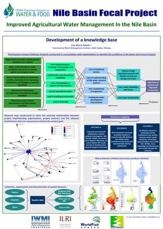
- 1. FU Berlin Improved Agricultural Water Management In the Nile Basin Development of a knowledge base Lisa‐Maria Rebelo 1 1 International Water Management Institute, Addis Ababa, Ethiopia Participatory Impact Pathway Analysis conducted in consultation with stakeholders to identify the problems in the basin and ensure impact: Major drivers of water related poverty identified and mapped Poor communications, Better understanding of water exchange of knowledge and availability and access at varying cooperation Lack of livelihood options Effects of high spatial and temporal scales population growth and Limited data and information density on land use Better understanding of production availability Lack of understanding change and water systems, mechanisms for improving of the water resource productivity, and linkages to poverty Lack of knowledge on systems High level of identified impacts of interventions poverty and Poor water availability degraded Poor institutional and access Overview of institutional ecosystems Lack of appropriate policy arrangement arrangements and required changes identified Lack of enabling environment Inadequate water Low water productivity Alternative water related development Lack of financing interventions Problem interventions and their impacts identified Network map constructed to show the evolving relationships between Outcome mapping: project implementing organizations, project partners and the ultimate beneficiaries that are necessary to achieve the project goal: Line Color Key Node Color Key OUTCOME C: OUTCOME A: Scaling Out Regional Organization OUTCOME B: Research CGIAR An effective network is Scaling Up NARES Improved and advanced Well maintained and easily developed and key Multiplex GO collaborative research accessible database is institutions from riparian Research Organization projects and programs. NBI, housed under NBI platform No Info countries which include NELSAP, ENSAP, CG Centers and collaborating ministries, universities, work together effectively not institutions have access and regional bodies such as NBI‐ only to deliver BFP results improved data sharing SVP, ENTRO, share but also to develop future mechanisms knowledge and disseminate research projects in the basin their results through the networks Many datasets collated and various products derived: Flow station rainfall station Collection, organisation and dissemination of spatial datasets: Integrate with Capture Nile databases Hand over to Organise Spatial data NBI KEY Rivers Water bodies Poverty level (%) KEY <15 River Nile 15 - 25 Water bodies Share Bio-Physical risks 25 - 35 Store in IDIS Very low Low Medium High 35 - 45 45 - 55 >55 Very high 0 145 290 580 870 1,160 No data Kilometers 0 290 580 870 1,160 Kilometers For more information contact: l.rebelo@cgiar.org