Factors to Consider When Choosing Accounts Payable Services Providers.pptx
Scenic Hudson Sea Level Rise Mapper - Part 3
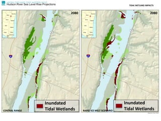
1. Hudson River Sea Level Rise Projections TIDAL WETLAND IMPACTS
CENTRAL RANGE RAPID ICE MELT SCENARIO
2080 2080
Inundated
Tidal Wetlands
Inundated
Tidal Wetlands
2. Hudson River Sea Level Rise Projections TIDAL WETLAND IMPACTS
CENTRAL RANGE RAPID ICE MELT SCENARIO
CURRENT CURRENT
3. Hudson River Sea Level Rise Projections TIDAL WETLAND IMPACTS
CENTRAL RANGE RAPID ICE MELT SCENARIO
2080 2080
Inundated
Tidal Wetlands
Inundated
Tidal Wetlands
4. Natural Resources at Risk
• 11,980 acres Tidal Wetlands and/or
Sub-Aquatic Vegetation at Risk
• Some are Globally Rare
• If Flooded, Can They Migrate?
A Roadmap for Sea Level Rise
Hudson Valley At Risk Statistics
7. Planning for Balanced Adaptation
•Wetland Migration Zones
•Highest Priority Public and Private
Infrastructure
•Key Opportunity & Conflict Areas
A Roadmap for Sea Level Rise
Adaptation Strategies
8. RESILIENCE PLANNING
ASSET DEFENSE
PROTECTION
RESTORATION
SHORELINE SOFTENING
LAND USE RESTRICTION
PROTECTION
Large to Medium Inundation Zone
Few Barriers
Little/No Infrastructure
Large to Medium Inundation Zone
Some Barriers Present
Some Infrastructure
Medium to Small Inundation Zone
Barriers Present
Major/Critical Infrastructure
Condition Strategy
13. Breakout Groups
A Roadmap for Sea Level Rise
Sea Level Rise Adaptation Roadmap:
1) Getting Started
2) Hazards and Climate
3) People and Communities
4) Built Environment
5) Natural Resources
6) Risk-wise Strategies
www.scenichudson.org/slr
14. Breakout Groups
A Roadmap for Sea Level Rise
•What resources are most vulnerable?
•What steps can be taken in your community?