Suche senden
Hochladen
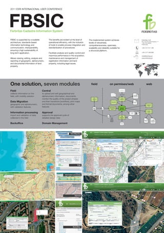
Cadastre Information System Poster - 2011 Esri IUC
•
0 gefällt mir
•
271 views
Fernando Gil
Folgen
Melden
Teilen
Melden
Teilen
1 von 1
Empfohlen
Õpidisaini printsiibid
Õpidisaini printsiibid
Kai Pata
Õppedisain1: Sissejuhatus
Õppedisain1: Sissejuhatus
Mart Laanpere
informatica ada 2
Actividad de aprendizaje 2 (bloque 3)
Actividad de aprendizaje 2 (bloque 3)
ghhjhjft
Datos estadísticos sobre la actividad contractual del Principado de Asturias Años 2012 - 2013
Estadisticas actividad contractual del principado de asturias (1)
Estadisticas actividad contractual del principado de asturias (1)
Carmen Garcia
Travel Counsellors Testimonial
Travel Counsellors Testimonial
Martin Walker
Naval Academy
Naval Academy
Liviu Vernis
ECG: Who We Are
ECG: Who We Are
Ivelisse Arroyo
INFORMAR A LOS JOVENES
SEÑOR KEVIN
SEÑOR KEVIN
kevin0967702501
Pasos para crear una presentacion en la web
Pasos para crear una presentacion en la web
dianapaolapinto
Melisa nerea-ayla-còmic-fotos4
Melisa nerea-ayla-còmic-fotos4
Saray128
Tesla 2
Tesla 2
BillBraski
BusinessProfile
BusinessProfile
Philippa Brangam
"Es cualquier juego inteligente desde el Wal-Mart/NASCAR audiencias de utilizar una gran cantidad de...
COPA: En Wal-Mart Patrocinador Jeff Gordonh
COPA: En Wal-Mart Patrocinador Jeff Gordonh
zapatillasrunning10
m871d.pdf
m871d.pdf
m871d.pdf
Jeff Smith
Explosão de dados do Bigdata, Inteligência Artificial e Marketing Preditivo. Saiba como tudo isso afeta definitivamente o processo de Marketing e Vendas. Neste evento damos uma visão de quais aplicações de Marketing preditivo podem transformar o seu negócio, segue uma pequena dos pontos que pretendo tocar nesta quarta: • Previsão de ROI de campanha • Sugestão de investimento baseado em metas • Profiling de consumo para apoio em marketing direto • Predictive Lead Scoring • Oferta contextual • Previsor de churn • Enriquecimento de dados contextual • Detecção de anomalias na jornada do Usuário
O que é marketing preditivo
O que é marketing preditivo
Conectt
Letter of Recommendation - RWaldburger 2016
Letter of Recommendation - RWaldburger 2016
Gretchen Barr
Toxoplasmosis Toxoplasma Gondhii
Toxoplasmosis
Toxoplasmosis
Jerlys Avilés Suira
Loenguslaidid Tallinna Ülikooli kursusel IFI6094.DT Kasutajakeskse disaini meetodid. 6. september 2016.
Sissejuhatus kursusesse
Sissejuhatus kursusesse
Hans Põldoja
ülikõva
Laua restaureerimine
Laua restaureerimine
GlitterFart
Õkoloogilise õpidisaini printsiibid
Okoloogilinedisain
Okoloogilinedisain
Kai Pata
evalveerimine
evalveerimine
Kai Pata
Põhikooli loovtöö ja uurimistöö
Põhikooli uurimistöö
Põhikooli uurimistöö
Kai Pata
The research focus of the developed work is concentrated on the implementation of Geographic Information Systems – GIS – tools in spatial and temporal contexts, linked to the GIS and Geospatial Information branch of IP. Through GIS it is possible to visualize, analyse, transform and interpret geographic information. For instance, identification of patterns, trends, and aspects that simplify decision support systems regarding geographical scenarios. Particularly, the work carried out consisted of detecting quarries. In this context, concepts of Artificial Intelligence, Machine Learning, and Deep Learning were considered. Combined with GIS resources and methodologies, it is conceivable to carry out spatial analysis, remote sensing, and information management, for example. The mechanisms adopted were initiated from the use of the Esri framework, a provider of geographic information systems, applied in Geographical Artificial Intelligence. GeoAI tools were adopted in the area of quarries, on which the developed work was focused. Whereas quarries may often be considered as relatively monitored and properly inspected areas, there are scenarios in which they are detected and exceed the specified geographical limits, and situations where they are considered illegal. Through the available tools, the occurrences mentioned above were intercepted with the national road and railway networks under the company’s supervision. As such, a workflow was developed, implemented, and paired with trained algorithms to obtain an approximate delimitation of the quarries in mainland Portugal.
Quarry Detection with GeoAI Tools on Infraestruturas de Portugal
Quarry Detection with GeoAI Tools on Infraestruturas de Portugal
Fernando Gil
"O programa de certificação graduada em Inteligência Geoespacial (certificado GEOINT), acreditado pela United States Geospatial Intelligence Foundation (USGIF) disponibiliza educação e formação em conceitos científicos, métodos e tecnologias geoespaciais chave utilizadas na resolução de problemas de segurança humana a nível global, incluindo desastres naturais, crises humanitárias, riscos ambientais, operações militares, violência política, saúde pública e desafios no acesso a fontes de alimentação. A USGIF (www.usgif.org) é a única organização dedicada à promoção da prática profissional da Inteligência Geoespacial (GEOINT) e à construção de uma comunidade de interesse cruzando a Indústria, a Academia, a Administração Pública e organizações profissionais. A USGIF é a única organização que providencia acreditação universitária na área da GEOINT, sendo a líder mundial nesta área." Mais informações em http://www.novaims.unl.pt/unigis
A pós-graduação em Inteligência Geoespacial (GEOINT Certificate) da NOVA IMS ...
A pós-graduação em Inteligência Geoespacial (GEOINT Certificate) da NOVA IMS ...
Fernando Gil
NOVA IMS's presentation at 2016 USGIF Accredited Academic Programs Summit (20161002).
2016 USGIF Accredited Academic Programs Summit - NOVA IMS
2016 USGIF Accredited Academic Programs Summit - NOVA IMS
Fernando Gil
Abstract The processes of mobilization of land for infrastructures of public and private domain are developed according to proper legal frameworks and systematically confronted with the impoverished national situation as regards the cadastral identification and regularization, which leads to big inefficiencies, sometimes with very negative impact to the overall effectiveness. This project report describes Ferbritas Cadastre Information System (FBSIC) project and tools, which in conjunction with other applications, allow managing the entire life-cycle of Land Acquisition and Cadastre, including support to field activities with the integration of information collected in the field, the development of multi-criteria analysis information, monitoring all information in the exploration stage, and the automated generation of outputs. The benefits are evident at the level of operational efficiency, including tools that enable process integration and standardization of procedures, facilitate analysis and quality control and maximize performance in the acquisition, maintenance and management of registration information and expropriation (expropriation projects). Therefore, the implemented system achieves levels of robustness, comprehensiveness, openness, scalability and reliability suitable for a structural platform. The resultant solution, FBSIC, is a fit-for-purpose cadastre information system rooted in the field of railway infrastructures. FBSIC integrating nature of allows: to accomplish present needs and scale to meet future services; to collect, maintain, manage and share all information in one common platform, and transform it into knowledge; to relate with other platforms; to increase accuracy and productivity of business processes related with land property management.
Fernando Gil's master thesis: "The implementation of an Enterprise Geographic...
Fernando Gil's master thesis: "The implementation of an Enterprise Geographic...
Fernando Gil
The processes of mobilization of land for infrastructures of public and private domain are developed according to proper legal frameworks and systematically confronted with the impoverished national situation as regards the cadastral identification and regularization, which leads to big inefficiencies, sometimes with very negative impact to the overall effectiveness. This project report describes Ferbritas Cadastre Information System (FBSIC) project and tools, which in conjunction with other applications, allow managing the entire life-cycle of Land Acquisition and Cadastre, including support to field activities with the integration of information collected in the field, the development of multi-criteria analysis information, monitoring all information in the exploration stage, and the automated generation of outputs. The benefits are evident at the level of operational efficiency, including tools that enable process integration and standardization of procedures, facilitate analysis and quality control and maximize performance in the acquisition, maintenance and management of registration information and expropriation (expropriation projects). Therefore, the implemented system achieves levels of robustness, comprehensiveness, openness, scalability and reliability suitable for a structural platform. The resultant solution, FBSIC, is a fit-for-purpose cadastre information system rooted in the field of railway infrastructures. FBSIC integrating nature of allows: to accomplish present needs and scale to meet future services; to collect, maintain, manage and share all information in one common platform, and transform it into knowledge; to relate with other platforms; to increase accuracy and productivity of business processes related with land property management.
Fernando Gil - Master Thesis Public Presentation (25/7/2014)
Fernando Gil - Master Thesis Public Presentation (25/7/2014)
Fernando Gil
130103 fbgis 2008_2012
130103 fbgis 2008_2012
Fernando Gil
Utilização dos SIG nos Caminhos-de-Ferro: • Cadastro e DPF • Gestão de Clientes • Gestão de Emergências • Gestão Ambiental • Mitigação Ambiental • Gestão e Arrendamento de Instalações • Recolha de Informação no Campo • Gestão de Imagens • Comunicação Inter-Ferrovias • Gestão da Supervisão • Gestão do Risco e da Segurança • Manutenção de Diagramas Lineares • Transportes e Logística • Gestão dos Trabalhadores • Gestão de Infra-estruturas • Projectos de Engenharia e Construção • Desenhos de Engenharia e Repositório de Registos • Monitorização de Activos • Gestão Imobiliária • Gestão de Riscos, Segurança e Vigilância • Análise da Cadeia de Fornecimento
Sistemas de Informação Geográfica aplicados à Rede Ferroviária
Sistemas de Informação Geográfica aplicados à Rede Ferroviária
Fernando Gil
Cadastre Information System Poster - 2012 ENG
Cadastre Information System Poster - 2012 ENG
Fernando Gil
Weitere ähnliche Inhalte
Andere mochten auch
Pasos para crear una presentacion en la web
Pasos para crear una presentacion en la web
dianapaolapinto
Melisa nerea-ayla-còmic-fotos4
Melisa nerea-ayla-còmic-fotos4
Saray128
Tesla 2
Tesla 2
BillBraski
BusinessProfile
BusinessProfile
Philippa Brangam
"Es cualquier juego inteligente desde el Wal-Mart/NASCAR audiencias de utilizar una gran cantidad de...
COPA: En Wal-Mart Patrocinador Jeff Gordonh
COPA: En Wal-Mart Patrocinador Jeff Gordonh
zapatillasrunning10
m871d.pdf
m871d.pdf
m871d.pdf
Jeff Smith
Explosão de dados do Bigdata, Inteligência Artificial e Marketing Preditivo. Saiba como tudo isso afeta definitivamente o processo de Marketing e Vendas. Neste evento damos uma visão de quais aplicações de Marketing preditivo podem transformar o seu negócio, segue uma pequena dos pontos que pretendo tocar nesta quarta: • Previsão de ROI de campanha • Sugestão de investimento baseado em metas • Profiling de consumo para apoio em marketing direto • Predictive Lead Scoring • Oferta contextual • Previsor de churn • Enriquecimento de dados contextual • Detecção de anomalias na jornada do Usuário
O que é marketing preditivo
O que é marketing preditivo
Conectt
Letter of Recommendation - RWaldburger 2016
Letter of Recommendation - RWaldburger 2016
Gretchen Barr
Toxoplasmosis Toxoplasma Gondhii
Toxoplasmosis
Toxoplasmosis
Jerlys Avilés Suira
Loenguslaidid Tallinna Ülikooli kursusel IFI6094.DT Kasutajakeskse disaini meetodid. 6. september 2016.
Sissejuhatus kursusesse
Sissejuhatus kursusesse
Hans Põldoja
ülikõva
Laua restaureerimine
Laua restaureerimine
GlitterFart
Õkoloogilise õpidisaini printsiibid
Okoloogilinedisain
Okoloogilinedisain
Kai Pata
evalveerimine
evalveerimine
Kai Pata
Põhikooli loovtöö ja uurimistöö
Põhikooli uurimistöö
Põhikooli uurimistöö
Kai Pata
Andere mochten auch
(14)
Pasos para crear una presentacion en la web
Pasos para crear una presentacion en la web
Melisa nerea-ayla-còmic-fotos4
Melisa nerea-ayla-còmic-fotos4
Tesla 2
Tesla 2
BusinessProfile
BusinessProfile
COPA: En Wal-Mart Patrocinador Jeff Gordonh
COPA: En Wal-Mart Patrocinador Jeff Gordonh
m871d.pdf
m871d.pdf
O que é marketing preditivo
O que é marketing preditivo
Letter of Recommendation - RWaldburger 2016
Letter of Recommendation - RWaldburger 2016
Toxoplasmosis
Toxoplasmosis
Sissejuhatus kursusesse
Sissejuhatus kursusesse
Laua restaureerimine
Laua restaureerimine
Okoloogilinedisain
Okoloogilinedisain
evalveerimine
evalveerimine
Põhikooli uurimistöö
Põhikooli uurimistöö
Mehr von Fernando Gil
The research focus of the developed work is concentrated on the implementation of Geographic Information Systems – GIS – tools in spatial and temporal contexts, linked to the GIS and Geospatial Information branch of IP. Through GIS it is possible to visualize, analyse, transform and interpret geographic information. For instance, identification of patterns, trends, and aspects that simplify decision support systems regarding geographical scenarios. Particularly, the work carried out consisted of detecting quarries. In this context, concepts of Artificial Intelligence, Machine Learning, and Deep Learning were considered. Combined with GIS resources and methodologies, it is conceivable to carry out spatial analysis, remote sensing, and information management, for example. The mechanisms adopted were initiated from the use of the Esri framework, a provider of geographic information systems, applied in Geographical Artificial Intelligence. GeoAI tools were adopted in the area of quarries, on which the developed work was focused. Whereas quarries may often be considered as relatively monitored and properly inspected areas, there are scenarios in which they are detected and exceed the specified geographical limits, and situations where they are considered illegal. Through the available tools, the occurrences mentioned above were intercepted with the national road and railway networks under the company’s supervision. As such, a workflow was developed, implemented, and paired with trained algorithms to obtain an approximate delimitation of the quarries in mainland Portugal.
Quarry Detection with GeoAI Tools on Infraestruturas de Portugal
Quarry Detection with GeoAI Tools on Infraestruturas de Portugal
Fernando Gil
"O programa de certificação graduada em Inteligência Geoespacial (certificado GEOINT), acreditado pela United States Geospatial Intelligence Foundation (USGIF) disponibiliza educação e formação em conceitos científicos, métodos e tecnologias geoespaciais chave utilizadas na resolução de problemas de segurança humana a nível global, incluindo desastres naturais, crises humanitárias, riscos ambientais, operações militares, violência política, saúde pública e desafios no acesso a fontes de alimentação. A USGIF (www.usgif.org) é a única organização dedicada à promoção da prática profissional da Inteligência Geoespacial (GEOINT) e à construção de uma comunidade de interesse cruzando a Indústria, a Academia, a Administração Pública e organizações profissionais. A USGIF é a única organização que providencia acreditação universitária na área da GEOINT, sendo a líder mundial nesta área." Mais informações em http://www.novaims.unl.pt/unigis
A pós-graduação em Inteligência Geoespacial (GEOINT Certificate) da NOVA IMS ...
A pós-graduação em Inteligência Geoespacial (GEOINT Certificate) da NOVA IMS ...
Fernando Gil
NOVA IMS's presentation at 2016 USGIF Accredited Academic Programs Summit (20161002).
2016 USGIF Accredited Academic Programs Summit - NOVA IMS
2016 USGIF Accredited Academic Programs Summit - NOVA IMS
Fernando Gil
Abstract The processes of mobilization of land for infrastructures of public and private domain are developed according to proper legal frameworks and systematically confronted with the impoverished national situation as regards the cadastral identification and regularization, which leads to big inefficiencies, sometimes with very negative impact to the overall effectiveness. This project report describes Ferbritas Cadastre Information System (FBSIC) project and tools, which in conjunction with other applications, allow managing the entire life-cycle of Land Acquisition and Cadastre, including support to field activities with the integration of information collected in the field, the development of multi-criteria analysis information, monitoring all information in the exploration stage, and the automated generation of outputs. The benefits are evident at the level of operational efficiency, including tools that enable process integration and standardization of procedures, facilitate analysis and quality control and maximize performance in the acquisition, maintenance and management of registration information and expropriation (expropriation projects). Therefore, the implemented system achieves levels of robustness, comprehensiveness, openness, scalability and reliability suitable for a structural platform. The resultant solution, FBSIC, is a fit-for-purpose cadastre information system rooted in the field of railway infrastructures. FBSIC integrating nature of allows: to accomplish present needs and scale to meet future services; to collect, maintain, manage and share all information in one common platform, and transform it into knowledge; to relate with other platforms; to increase accuracy and productivity of business processes related with land property management.
Fernando Gil's master thesis: "The implementation of an Enterprise Geographic...
Fernando Gil's master thesis: "The implementation of an Enterprise Geographic...
Fernando Gil
The processes of mobilization of land for infrastructures of public and private domain are developed according to proper legal frameworks and systematically confronted with the impoverished national situation as regards the cadastral identification and regularization, which leads to big inefficiencies, sometimes with very negative impact to the overall effectiveness. This project report describes Ferbritas Cadastre Information System (FBSIC) project and tools, which in conjunction with other applications, allow managing the entire life-cycle of Land Acquisition and Cadastre, including support to field activities with the integration of information collected in the field, the development of multi-criteria analysis information, monitoring all information in the exploration stage, and the automated generation of outputs. The benefits are evident at the level of operational efficiency, including tools that enable process integration and standardization of procedures, facilitate analysis and quality control and maximize performance in the acquisition, maintenance and management of registration information and expropriation (expropriation projects). Therefore, the implemented system achieves levels of robustness, comprehensiveness, openness, scalability and reliability suitable for a structural platform. The resultant solution, FBSIC, is a fit-for-purpose cadastre information system rooted in the field of railway infrastructures. FBSIC integrating nature of allows: to accomplish present needs and scale to meet future services; to collect, maintain, manage and share all information in one common platform, and transform it into knowledge; to relate with other platforms; to increase accuracy and productivity of business processes related with land property management.
Fernando Gil - Master Thesis Public Presentation (25/7/2014)
Fernando Gil - Master Thesis Public Presentation (25/7/2014)
Fernando Gil
130103 fbgis 2008_2012
130103 fbgis 2008_2012
Fernando Gil
Utilização dos SIG nos Caminhos-de-Ferro: • Cadastro e DPF • Gestão de Clientes • Gestão de Emergências • Gestão Ambiental • Mitigação Ambiental • Gestão e Arrendamento de Instalações • Recolha de Informação no Campo • Gestão de Imagens • Comunicação Inter-Ferrovias • Gestão da Supervisão • Gestão do Risco e da Segurança • Manutenção de Diagramas Lineares • Transportes e Logística • Gestão dos Trabalhadores • Gestão de Infra-estruturas • Projectos de Engenharia e Construção • Desenhos de Engenharia e Repositório de Registos • Monitorização de Activos • Gestão Imobiliária • Gestão de Riscos, Segurança e Vigilância • Análise da Cadeia de Fornecimento
Sistemas de Informação Geográfica aplicados à Rede Ferroviária
Sistemas de Informação Geográfica aplicados à Rede Ferroviária
Fernando Gil
Cadastre Information System Poster - 2012 ENG
Cadastre Information System Poster - 2012 ENG
Fernando Gil
Sistema de Identificação Cadastral Poster - 2012 Esri Portugal EU
Sistema de Identificação Cadastral Poster - 2012 Esri Portugal EU
Fernando Gil
Sistema de Informação Cadastral Poster - 2011 Esri Brasil EU
Sistema de Informação Cadastral Poster - 2011 Esri Brasil EU
Fernando Gil
The concepts of integration, complementarity and coordination are particularly important especially in the field of railway infrastructures. The requirements of the associated interventions are very technical in nature and involve multiple specialties and technologies, and the final result is only guaranteed if the various components of this interwoven puzzle are compatible and properly joined together.
Cadastre Information System for Rail in Portugal
Cadastre Information System for Rail in Portugal
Fernando Gil
Serviços de Actualização do Parcelário Olivícola - SIGOL (2002)
Serviços de Actualização do Parcelário Olivícola - SIGOL (2002)
Fernando Gil
Ficheiro Vitivinícola Comunitário em Portugal. Instalação Do Sistema - SIGV (...
Ficheiro Vitivinícola Comunitário em Portugal. Instalação Do Sistema - SIGV (...
Fernando Gil
EROSÃO HÍDRICA NA BACIA HIDROGRÁFICA DO RIO SÉQUA (Evolução da erosão entre os períodos de 1930/60 e 1960/90)
EROSÃO HÍDRICA NA BACIA HIDROGRÁFICA DO RIO SÉQUA (Evolução da erosão entre o...
EROSÃO HÍDRICA NA BACIA HIDROGRÁFICA DO RIO SÉQUA (Evolução da erosão entre o...
Fernando Gil
Mestrado/Pós-graduação em Ciência & SIG Trabalho Final - Detecção Remota Produção de Mapas Temáticos com Utilização de Classificação Orientada a Objectos (Leziria Grande de Vila Franca de Xira)
Produção de Mapas Temáticos com Utilização de Classificação Orientada a Objec...
Produção de Mapas Temáticos com Utilização de Classificação Orientada a Objec...
Fernando Gil
Mestrado/Pós-graduação em Ciência & SIG Trabalho final da cadeira de Bases de Dados Base de Dados para Gestão de um Perímetro de Rega - vertentes administrativa, territorial e documental
Base de Dados para Gestão de um Perímetro de Rega - vertentes administrativa,...
Base de Dados para Gestão de um Perímetro de Rega - vertentes administrativa,...
Fernando Gil
Mestrado/Pós-graduação em Ciência & SIG Trabalho Final - Ciência & SIG Aplicação dos SIG ao Controlo das Ajudas Comunitárias à Agricultura
Aplicação dos SIG ao Controlo das Ajudas Comunitárias à Agricultura (MSc Ciên...
Aplicação dos SIG ao Controlo das Ajudas Comunitárias à Agricultura (MSc Ciên...
Fernando Gil
Sistema de Informação Geográfica de Projectos de Engenharia Ferroviária
Sistema de Informação Geográfica de Projectos de Engenharia Ferroviária
Fernando Gil
Ferbritas presentation at Geospatial World Forum 2012 (please click in slide 23 to start the video demo)
Cadastre Information System - GWF 2012, Amsterdam
Cadastre Information System - GWF 2012, Amsterdam
Fernando Gil
In summary, FBSIC enable to maintain an organized and structured database, which identifies land property in all its aspects - physical, descriptive, legal and tax – allowing to relate information concerning the owner (documental and alphanumeric) to property (topographic, cartographic, physical, documental and alphanumeric).
Cadastre Information System (Brochure ENG)
Cadastre Information System (Brochure ENG)
Fernando Gil
Mehr von Fernando Gil
(20)
Quarry Detection with GeoAI Tools on Infraestruturas de Portugal
Quarry Detection with GeoAI Tools on Infraestruturas de Portugal
A pós-graduação em Inteligência Geoespacial (GEOINT Certificate) da NOVA IMS ...
A pós-graduação em Inteligência Geoespacial (GEOINT Certificate) da NOVA IMS ...
2016 USGIF Accredited Academic Programs Summit - NOVA IMS
2016 USGIF Accredited Academic Programs Summit - NOVA IMS
Fernando Gil's master thesis: "The implementation of an Enterprise Geographic...
Fernando Gil's master thesis: "The implementation of an Enterprise Geographic...
Fernando Gil - Master Thesis Public Presentation (25/7/2014)
Fernando Gil - Master Thesis Public Presentation (25/7/2014)
130103 fbgis 2008_2012
130103 fbgis 2008_2012
Sistemas de Informação Geográfica aplicados à Rede Ferroviária
Sistemas de Informação Geográfica aplicados à Rede Ferroviária
Cadastre Information System Poster - 2012 ENG
Cadastre Information System Poster - 2012 ENG
Sistema de Identificação Cadastral Poster - 2012 Esri Portugal EU
Sistema de Identificação Cadastral Poster - 2012 Esri Portugal EU
Sistema de Informação Cadastral Poster - 2011 Esri Brasil EU
Sistema de Informação Cadastral Poster - 2011 Esri Brasil EU
Cadastre Information System for Rail in Portugal
Cadastre Information System for Rail in Portugal
Serviços de Actualização do Parcelário Olivícola - SIGOL (2002)
Serviços de Actualização do Parcelário Olivícola - SIGOL (2002)
Ficheiro Vitivinícola Comunitário em Portugal. Instalação Do Sistema - SIGV (...
Ficheiro Vitivinícola Comunitário em Portugal. Instalação Do Sistema - SIGV (...
EROSÃO HÍDRICA NA BACIA HIDROGRÁFICA DO RIO SÉQUA (Evolução da erosão entre o...
EROSÃO HÍDRICA NA BACIA HIDROGRÁFICA DO RIO SÉQUA (Evolução da erosão entre o...
Produção de Mapas Temáticos com Utilização de Classificação Orientada a Objec...
Produção de Mapas Temáticos com Utilização de Classificação Orientada a Objec...
Base de Dados para Gestão de um Perímetro de Rega - vertentes administrativa,...
Base de Dados para Gestão de um Perímetro de Rega - vertentes administrativa,...
Aplicação dos SIG ao Controlo das Ajudas Comunitárias à Agricultura (MSc Ciên...
Aplicação dos SIG ao Controlo das Ajudas Comunitárias à Agricultura (MSc Ciên...
Sistema de Informação Geográfica de Projectos de Engenharia Ferroviária
Sistema de Informação Geográfica de Projectos de Engenharia Ferroviária
Cadastre Information System - GWF 2012, Amsterdam
Cadastre Information System - GWF 2012, Amsterdam
Cadastre Information System (Brochure ENG)
Cadastre Information System (Brochure ENG)