Cadastre Information System for Rail in Portugal
•
1 gefällt mir•664 views

The concepts of integration, complementarity and coordination are particularly important especially in the field of railway infrastructures. The requirements of the associated interventions are very technical in nature and involve multiple specialties and technologies, and the final result is only guaranteed if the various components of this interwoven puzzle are compatible and properly joined together.

Empfohlen
Weitere ähnliche Inhalte
Andere mochten auch
Andere mochten auch (7)
Ähnlich wie Cadastre Information System for Rail in Portugal
Ähnlich wie Cadastre Information System for Rail in Portugal (20)
Mehr von Fernando Gil
Mehr von Fernando Gil (20)
Kürzlich hochgeladen
Kürzlich hochgeladen (20)
Cadastre Information System for Rail in Portugal
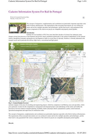
- 1. Cadastre Information System For Rail In Portugal Page 1 of 6 Cadastre Information System For Rail In Portugal Written by Fernando Gil and Luís Mata Thursday, 16 June 2011 12:18 The concepts of integration, complementarity and coordination are particularly important especially in the field of railway infrastructures. The requirements of the associated interventions are very technical in nature and involve multiple specialties and technologies, and the final result is only guaranteed if the various components of this interwoven puzzle are compatible and properly joined together. Introduction Ferbritas SA was founded in 1976. Over more than three decades of existence has undergone many changes arising from processes of development and growth, which contributed significantly to the technical independence of the national railway, through the systematic and progressive development of skills in several areas of specialty. Ferbritas is currently dedicated to the transport sector and in particular the railway (light, heavy, conventional and high speed). It is the only Fig. 1 - Central Module Overview national company in the areas of consulting and engineering projects, which has competence in all Railway areas and specialties, which gives particular vocation for the comprehensive management and integrated projects and undertakings of this nature and enables the provision of services related to transport planning, feasibility studies and project detail; expropriations; quality control materials, specialized management and supervision of construction works. The concepts of integration, complementarity and coordination are particularly important especially in the field of railway infrastructures. The requirements of the associated interventions are very technical in nature and involve multiple specialties and technologies, and the final result is only guaranteed if the various components of this interwoven puzzle are compatible and properly joined together. Rail lifecycle http://www.vector1media.com/article/features/20982-cadastre-information-system-for... 01-07-2011
- 2. Cadastre Information System For Rail In Portugal Page 2 of 6 Fig. 2 - Central Module Parcel View Moreover, linear infrastructures such as roads, rail, energy, etc. are long lasting, and with long lifecycles. Starting at the planning stage, these infrastructures can last for several decades, during which information is produced by multiple generations and organizations, running the risk of not being used at present, or future, or even get lost in time, if not properly organized and maintained. The resulting information and knowledge have high economic value and significance for organizations, making it vital to preserve. http://www.vector1media.com/article/features/20982-cadastre-information-system-for... 01-07-2011
- 3. Cadastre Information System For Rail In Portugal Page 3 of 6 Fig. 3 - FBSIC Main Modules Although the immediate reason for the development of this information system stems from the need to provide a complete answer to the dynamic control of the registration and real estate status of the national rail infrastructure, the results obtained are of relevance to individuals, companies and public administration. Land asset management is a cross cutting societal topic which is the basis for many economic and control activities. This results as very important since the opportunity and return on investment on, for instances, ownership transfers, land use and taxation cannot be based on inadequate or wrong information. For these reasons, from the beginning, the Cadastre Information System (FBSIC) was designed to meet the needs of the rail sector and beyond. It also is applicable to the activities of entities or organizations to which it is important to ensure the dynamic control of cadastral and real estate property. The terrain, the cadastral and real estate control. Processes The processes of mobilization of land for infrastructures of public and private domain are developed according to proper legal frameworks and systematically confronted with the impoverished national situation as regards the cadastral identification and regularization, which leads to big inefficiencies, sometimes with very negative impact to the overall effectiveness. Fig. 4 - Public Domain Management Module (Initial Page) The process started with collecting and processing information from the “foundations” and continues building up the collection of valuable information that the company already has that got; seeking its immediate availability to the customer and all specialties of internal needs and also permits its use for other purposes such as asset appreciation. Adopt a geographic information technology and develop the required software, properly integrated with other information subsystems of the organization, focused on the production and business management. First we proceed to update the design of the technical and business processes, then the objectives were detailed and the technological platform selected, which were the preconditions to start the project. From this point, the implementation process followed a standard design with the establishment of requirements, functional analysis, application design and related developments. http://www.vector1media.com/article/features/20982-cadastre-information-system-for... 01-07-2011
- 4. Cadastre Information System For Rail In Portugal Page 4 of 6 Tools for rail integration Application Server: Database Server: Desktop ArcGIS: ○ Hardware: ○ Hardware: ○ ArcInfo and ArcEditor 10; ■VM (VMware) with 8GB of RAM ■VM (VMware) with 8GB of RAM; ○ ArcView 10 (single use), ○ Operating System: ○ Operating System: ○ Spatial Analyst 10 competitor, ■Windows Server 2008 R2 Std x64, ■Windows Server 2008 ○ 3D Analyst 10, IIS 7.5 (compatible 6) ; R2 STD x64; ○ Network Analyst 10; ○ GIS: ○ Database: ○ ArcGIS Data Interoperability 10; ■ArcGIS Server 10 Enterprise ■SQL Server Enterprise 2008 ○ ArcGIS Publisher; Standard x64 SP1; ○ ArcPad 10. (ArcSDE 10); ○ FBSIC Applications: ● ArcGIS Server 10: ■ArcGIS Image Server 10. ■Geographic Migration Module: ○ ArcGIS Server 10 Enterprise ○ Web Application: ArcGIS Extensions (ArcObjects); Standard; ■Developed in C # ■Field Module: Windows Forms; ○ ArcGIS Image Server 10. (Web Application Developer ■Information Processing Module: Framework for the Microsoft. NET Windows Forms; Framework -. NET Web ADF ) ■Central Module: Adobe Flex; / JavaScript, ■BackOffice Module: Site Aspx; MS Visual Studio 2008, ■Approval Module: Adobe Flex; framework v4 ■Public Domain Management Module: Adobe Flex Project implementation Initially a prototype was developed to support better decisions on the system to implement. In the next stage, we proceed with the implementation of the Cadastre Information System (FBSIC). The project team was designed to adequately cover the needs of business and is therefore composed of elements from the functional units that have the "know-how” of the business, coordinated by the GIS team and supported by an information systems team, with the direct involvement of the first level of management. Another condition, that is also essential to promoting the integration of internal and external resources, is performing the work at the premises of Ferbritas. Fig. 5 - Public Domain Management Module (Querying a Land Parcel) Cadastre Information System (FBSIC) is a first step of a business strategy that has multiple purposes, particularly related to increased value for customers and for the reference shareholder, with the efficiency of services, information integrity, the generation and the "democratization" of knowledge in a timeless framework. The SIC is used permanently for three areas of business and has allowed to formulate new innovative services, and respond to the needs expressed by clients. They are metrics established that have confirmed the efficiency gains and significant rigor established in pilot projects developed in the testing phase and will be confirmed after the entry into production at cruising speed. http://www.vector1media.com/article/features/20982-cadastre-information-system-for... 01-07-2011
- 5. Cadastre Information System For Rail In Portugal Page 5 of 6 Benefits of the project The FBSIC is supported by a scalable architecture, standards-based information technology and communication, and interoperability, ensuring a high sustainability of long-term application. Allows viewing and editing of geographic and alphanumeric information of expropriation projects. Has a modular character, comprising: ● Data Migration Module (geographic and alphanumeric), with some features for element validation; ● Field Module (supporting the activities of gathering information); ● Information Processing Module (import and validation of field data); ● Central Module (which provides tools that enable: load and edit information on a geographical, alphanumeric and document basis, monitor the quality of the project phases and their transitions (workflow); print maps and formal documents, among other features); ● Backoffice Module to support the system administrator; ● Approval Module (enables to perform a cycle of approval of the design data before sending to DUP); ● Public Domain Management Module (enables to perform the management cycle of land parcels till their acquisition by the national authorities); The benefits are evident at the level of operational efficiency, with including tools that enable process integration and standardization of procedures, facilitate analysis and quality control and maximize performance in the acquisition, maintenance and management of registration information and expropriation (expropriation projects). The implemented system achieves levels of robustness, comprehensiveness, openness, scalability and reliability suitable for a structural platform. Results FBSIC tools, in conjunction with other applications for Registration and Expropriation Projects, allow managing the entire life-cycle of projects of expropriation and cadastre, including support to field activities with the integration of information collected in the field, the development of multi-criteria analysis information and monitoring of projects in the exploration stage. The integrative nature of the architecture allows Ferbritas fit current needs, providing the possibility of scaling the platform to meet future services. The application has increased the rigor and productivity of the cadastre and expropriation process, and represents to the company a solution to information management of Cadastre and Expropriation Projects, including all other additional background information. ----------------------------------------------------------------------- Fernando Gil and Luís Mata - Ferbritas, S.A., Lisbon, Portugal e-mail: fgil@ferbritas.pt 9 1 8 2 retweet 36 Share Comments (0) Add New Search RSS Write comment Your Contact Details: Name: Email: do not notify Website: Comment: Title: Message: http://www.vector1media.com/article/features/20982-cadastre-information-system-for... 01-07-2011
- 6. Cadastre Information System For Rail In Portugal Page 6 of 6 Security Please input the anti-spam code that you can read in the image. Send Joomla components by Compojoom http://www.vector1media.com/article/features/20982-cadastre-information-system-for... 01-07-2011