How GIS Improved Productivity for LA Sanitation's Trash Collection
•
0 gefällt mir•483 views

LA's Bureau of Sanitation deployed a GIS that has recouped more than 200 hours of productivity per week.

Empfohlen
Empfohlen
Weitere ähnliche Inhalte
Ähnlich wie How GIS Improved Productivity for LA Sanitation's Trash Collection
Ähnlich wie How GIS Improved Productivity for LA Sanitation's Trash Collection (20)
Mehr von Esri
Mehr von Esri (20)
Kürzlich hochgeladen
Kürzlich hochgeladen (20)
How GIS Improved Productivity for LA Sanitation's Trash Collection
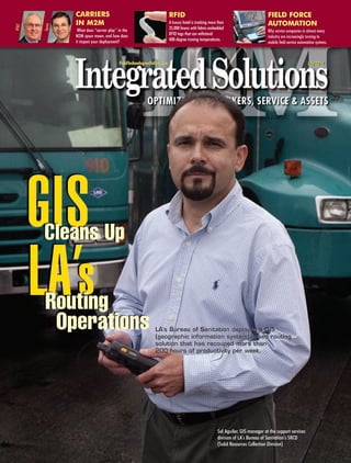
- 1. CARRIERS RFID FIELD FORCE IN M2M A luxury hotel is tracking more than AUTOMATION Sprint AT&T What does “carrier play” in the 35,000 linens with fabric-embedded Why service companies in almost every M2M space mean, and how does RFID tags that can withstand industry are increasingly turning to it impact your deployment? 400-degree ironing temperatures. mobile field service automation systems. FieldTechnologiesOnline.com July 2010 LA’s Bureau of Sanitation deployed a GIS (geographic information system)-based routing solution that has recouped more than 200 hours of productivity per week. Sal Aguilar, GIS manager at the support services division of LA’s Bureau of Sanitation’s SRCD (Solid Resources Collection Division)
- 2. Drivers at LA’s Bureau of Sanitation’s SRCD (solid resources collection division) are now using GIS-based routing software on Motorola handheld computers. photos by Eric Laycock
- 3. GIS Cleans Up LA’s Routing Operations LA’s Bureau of Sanitation deployed a GIS (geographic information system) that has recouped more than 200 hours of productivity per week. by Sarah Howland f you’re asked to picture the city of Los Angeles, what image do you see? I You may envision the glitz and glamour of Hollywood, imagine all of the stars and attractive people walking the streets, or visualize the beautiful sunshine and palm trees intrinsic to the area. An image that probably doesn’t enter your mind’s eye is the 1.5 million tons of trash the 3,849,378 inhabitants of LA produce each year. Yes, that’s right — 1.5 million tons. Why isn’t this staggering amount of trash the first thing you think of? You can thank the city’s Bureau of Sanitation, which exists to keep the city clean. The SRCD (solid resources collection division) within LA’s Bureau of Sanitation performs two primary functions — collection activities and container services man- agement. The SRCD is responsible for collecting refuse, yard trimmings, and recy- clables from the 2.3 million city-issued containers throughout LA. In addition to reg- ularly scheduled collection pickups, the SRCD employs 60 special collection drivers who collect bulky items such as sofas, washing machines, and refrigerators by appointment. These 60 drivers complete about 55,000 pickup requests each month. The SRCD also employs 20 drivers who issue, replace, and repair contain- ers upon customer request. All requests from the city are handled through the bureau’s central call center, which distributes jobs according to the city’s six SRCD district yard locations and single container service warehouse. Not too long ago, the process the bureau used to route its SRCD special collection and container services was a purely manual process. However, this manual process was unable to keep up when many of the 2.3 million city-issued containers began to reach the end of their life cycles, and requests for replacement skyrocketed. At this point, the bureau turned to a GIS to automate its routing process and increase the efficiency of its drivers. Paper-Based Routing Time Consuming, Manual Data Collection Error Prone Before the bureau deployed a GIS, calls coming in to the centralized call center were entered into a proprietary database and forwarded to the appropriate district yard or warehouse. The supervisor at the district yard or container services ware-
- 4. Feature Article house then printed out jobs grouped by ZIP code and dis- all of its GIS initiatives for years, so Aguilar was familiar tributed them evenly among drivers, who were responsi- with ArcLogistics from ESRI. ArcLogistics is a desktop ble for organizing the jobs in the way they thought made routing solution that comes preloaded with GIS map most sense and routing themselves based on their knowl- data from NAVTEQ and optimizes routes based on edge of the area. While in the field, the drivers were geocoded customer addresses, estimated drive times responsible for keeping manual notes on each job, between locations, and driver skills and schedules. including information on when the job was completed or ArcLogistics would integrate with the bureau’s propri- reasons for jobs uncompleted. For example, if a request etary call center database so that as appointments are for pickup was made but the customer forgot to leave the entered into the database, optimized schedules and item out, the job can’t be done and the reason needs to routes are automatically generated for each driver. be recorded. The container services drivers also had to “While ESRI had a longstanding reputation within LA manually record a 13-digit serial number, used to associ- and was the first vendor that came to mind when I start- ate a specific container with a specific address, from each ed this project, I wouldn’t have chosen ArcLogistics if it container they serviced. weren’t the best-fitting solution for our needs,” The paper-based routing and data collection processes explains Aguilar. the bureau was using presented a few inefficiencies. First, And it was, for the city’s appointment-based (or point- all drivers attended a meeting each morning to obtain a to-point) routing. For regular pickup (or continuous) job list for the day and determine the routes they’d take, routing, however, Aguilar chose RouteSmart, which is “The 30 minutes each driver spent going over paper-based routes each morning was productive time we were losing out on.” Sal Aguilar, LA’s Bureau of Sanitation which lasted about 30 minutes. “The 30 minutes each dri- routing software used mainly in the public works sectors. ver spent going over paper-based routes every morning RouteSmart plugs into the ESRI ArcGIS Desktop (soft- was productive time we were losing out on,” notes Sal ware used to organize and analyze the bureau’s GIS data) Aguilar, GIS manager at the bureau’s support services divi- so it uses the same GIS data as ArcLogistics, but uses its sion of the SRCD. “Also, the manual data collection the dri- own unique algorithms to accommodate continuous vers were doing in the field left a lot of room for human routing-specific needs, including cluster workloads, error, especially with the manual recording of 13-digit ser- sequencing stops, side-of-street specific routing, and trips ial numbers.” Not to mention, the data entry work was to intermediate facilities (i.e. disposal sites). duplicated by clerks who had to enter all of the drivers’ handwritten notes into the bureau’s database at the end of Public Works Environment Necessitates each day. “There was a lot of ‘is this a 1 or an I?’ when it Rugged Devices For Mobile GIS came to the data entry clerks reading the drivers’ notes, While ArcLogistics and RouteSmart would take care of which resulted in a lot of time spent on this task and inac- the challenges of routing drivers more efficiently, the curate data being entered into the database,” adds Aguilar. bureau still needed a way to mobilize this information These inefficiencies were compounded when many of to eliminate the need for paper route printouts for dri- the city’s containers began to reach the end of their life vers. Further, Aguilar wanted to solve the problem of cycles at once, resulting in a higher volume of requests. hand-written notes and manual data collection. To When the volume of calls increased dramatically for con- accomplish these goals, he chose another product from tainer services, the bureau decided to implement a sys- ESRI — ArcPad, which also plugs into ArcGIS Desktop. tematic container replacement program. Rather than wait ArcPad is mobile GIS software that would enable the for each and every resident with an aging container to call bureau to push out driver schedules and routes direct- in and make an appointment, the bureau decided to ly to a mobile device, as well as allow the creation of proactively replace each container that was reaching the electronic forms to enable automated data collection in end of its expected life cycle. However, for this program the field. Aguilar chose Motorola MC70 devices to to work the way the bureau was envisioning it, a more deploy ArcPad. “Rugged devices are essential in our efficient routing system was crucial. case,” says Aguilar. “The devices are constantly bounc- ing around in the large garbage trucks, being dropped GIS Quells Routing Woes on the road, etc. An iPhone wouldn’t last a week in this While Aguilar spent some time researching various application.” routing vendors online, he entered his search with a Once Aguilar had chosen the components of the solu- solution already in mind. LA has used ESRI software for tion, installation began. The bureau started with the
- 5. Feature Article deployment of ArcGIS Desktop, ArcLogistics, ArcPad, and The Reach Of GIS RouteSmart at the container warehouse and each of the six district yards. Aguilar first trained his team of four GIS spe- cialists on ArcGIS, ArcLogistics, ArcPad, and RouteSmart in a train-the-trainer fashion. The team then completed the installation of software at each location, which included loading the software, setting up the Access database inter- When Sal Aguilar, GIS (geographic information faces with the proprietary call center database, and provid- system) manager at the support services divi- ing hands-on training to the users of the software. “The sion of the SRCD (solid resources collection divi- ESRI solutions are out-of-the-box, so they took virtually no sion) of LA’s Bureau of Sanitation, decided to programming,” says Aguilar. “Our time was spent loading deploy a GIS-based route optimization solution, the software, and then training users on how to properly ESRI was the first vendor to come to mind. “ESRI enter calls and forward routes to the drivers’ mobile has a long-standing relationship with LA, is used devices.” This process took about one month per location. for all GIS-based When the routing solution was up and running, it was projects, and is time to deploy ArcPad on the Motorola MC70s to the dri- seen as the city vers. For this process to begin, however, the GIS team first standard for GIS had to create the customized form drivers would use to technology,” he complete notes on the job. The electronic form enables explains. How- the driver to select the stop they’re at, complete a refer- ever, ESRI’s rep- ence number for the call center, enter a resolution code utation alone (i.e. job complete, not complete because container wasn’t wasn’t going to available, etc.), and for the container services drivers to sell Aguilar on scan the bar code on each container using the embedded ArcLogistics, its bar code scanner on the MC70. route optimiza- With the form complete, the GIS team loaded the soft- tion solution. ware onto the Motorola MC70s and began to roll out What did sell ArcPad at the first district yard. “We chose the district yard him? The fact that had the youngest average driver age to deploy to first,” Drivers at LA’s Bureau of Sanitation have replaced manu- that ESRI’s solu- al data collection with an automated process thanks to tions are able to says Aguilar. “We felt the younger drivers would be more ArcPad software from ESRI, deployed on Motorola MC70 accepting of the technology and more apt to provide good handhelds. be deployed out feedback, whereas the more tenured drivers who’ve been of the box, but using the paper process longer would be more likely to are also scalable and can be built on over time. have difficulty with the transition.” The GIS team first con- “The software has a lot of capability, but you ducted a 2-hour, classroom-style training with the drivers can also keep it simple,” explains Aguilar. “You and office staff of each location to provide an overview of can use ArcLogistics right out of the box for the solution, and then went on ride-alongs with each dri- routing alone, but you can also take it further to ver to provide hands-on training on the solution. analyze route data, determine patterns of when According to Aguilar, the drivers needed one and a half residents set out trash, etc.” For example, now days of ride-alongs on average before feeling comfortable that the bureau has its basic routing automat- using the solution on their own. The rollout of ArcPad at ed, Aguilar has also set out to implement the each location took between two and three months. concept of ORBA (operational route-based analysis) on its 2,500+ continuous service GIS Streamlines Routing, routes. ORBA will enable the bureau to look at Enables Automated Data Collection the operational parameters of the routes and Now, when a customer calls in to the call center with a display them spatially to analyze the relation- request for an appointment, the appointment is entered ships between them and determine where into the bureau’s database, which is imported at end of day improvements can be made. to ArcLogistics. ArcLogistics then optimizes routes based on Indeed, the uses for GIS are vast. ESRI pro- the date of the appointment, the district yard the appoint- vides solutions to a number of verticals other ment falls in, and by driver and exports these routes daily than public works, including military, educa- to a file for each individual driver that is sent directly to the tion, healthcare, agriculture, public safety, driver’s MC70. Drivers stop by their base location in the transportation, and utilities. Besides schedul- morning to pick up the MC70, and then complete an elec- ing and routing, GIS can be used for naviga- tronic, drop-down-based form for each appointment they tion, data management and mapping, and complete. Routes for continuous service locations, created market analysis. For more information on ESRI, in RouteSmart based on the area that needs service that day visit www.esri.com. and which driver will accomplish which portion, are dis- tributed in the same way. At the end of their shifts, the dri- vers drop the MC70s back off at their location to sync them,
- 6. the special collection and container divisions do now, but include real-time cellular communication because of the more urgent nature of DAC jobs. “GIS can play an integral role in any operation,” says Aguilar. “The ability to take data that has formerly been looked at in a tabular format and have it be spa- tially referenced, analyzed, and automatically mapped is a powerful tool that can help any organization.” Indeed, Aguilar’s point is a valid one — while LA’s use of a GIS is a great example of how GIS can be used for routing in a public works application, the reach of GIS is really much broader. No matter what vertical market you’re in — or whether your business need is sched- Aguilar, along with his team of GIS specialists, performed ride-alongs with the drivers of the SRCD uling and routing, navigation, mapping, or business to train them on the ArcPad solution deployed on Motorola MC70 handheld computers. Each dri- ver took an average of one and a half days to get up to speed on the solution. analysis — it is worth taking a look at the role a GIS could play in your organization. G which uploads all of the form information gathered throughout the day to the bureau’s database. While Aguilar did consider enabling the devices with cellular service to allow real-time data transfer versus having to sync the devices, he says the benefit of doing Sarah Howland is an editor at so wasn’t worth the added cost, which would be Integrated Solutions and approximately $34,440 annually for a cellular data Field Technologies Online. plan. “A customer who calls to have a pickup appoint- She can be reached at: ment isn’t going to call back that same day to check on sarah.howland@isminfo.com. it; it’ll be the next day,” he explains. “We aren’t in the type of service industry, like break/fix, where people are waiting for us to arrive. The cost of that real-time com- munication really isn’t worth it for us.” Since deploying the GIS-based routing solutions and ArcPad automated data collection, the bureau has elimi- nated the coordination meetings the teams used to hold each morning. While a half hour may not seem like huge savings, it is when you think about how many people were spending that half hour. By eliminating the 30 min- utes its 82 drivers were spending each morning in the routing meeting, the bureau has recouped more than 200 hours per week of productive time. Moreover, drivers are completing 30% more stops per day, which enabled the 380 New York Street teams to absorb the increased volume they experienced Redlands, California when many of the containers reached the end of their life 92373-8100 USA cycles at once, without hiring additional drivers. Lastly, 1-800-GIS-XPRT (1-800-447-9778) the automated data capture solution has eliminated the necessary data entry time and common data entry errors Phone: 909-793-2853 of the paper-based method. Fax: 909-793-5953 In the near future, the bureau is planning to info@esri.com upgrade to the latest version of ArcLogistics, and www.esri.com Aguilar plans to replace the Motorola MC70s with Offices worldwide the newer Motorola MC75A. Aguilar is also piloting a project for the bureau’s DAC (dead animal collec- www.esri.com/locations tion) division, which currently uses pagers for rout- ing. He plans to deploy ArcLogistics for routing, Copyright © 2010 Esri. All rights reserved. Esri, ArcLogistics, ArcGIS Desktop, ArcPad, the Esri globe logo, @esri.com, and www.esri.com are trademarks, ArcNavigator for real-time turn-by-turn navigation registered trademarks, or service marks of Esri in the United States, the European Community, or certain other jurisdictions. Other companies and and on-the-fly rerouting, and ArcPad for field data products mentioned herein may be trademarks or registered trademarks of their respective trademark owners. collection on the Motorola MC75A, similar to how 123321 4/10sp123 Posted with permission from Integrated Solutions. Copyrighted 2010. For subscription information, call (814) 868-9935 or visit www.IntegratedSolutionsMag.com. #1-27994045 Managed by The YGS Group, 717.505.9701. For more information visit www.theYGSgroup.com/reprints.