SlideShare ist ein Scribd-Unternehmen logo
1 von 1
Downloaden Sie, um offline zu lesen
Complete GIS for Maritime Users
Technology disrupters such as mobile, cloud, and new data technology are allowing people
to look at how they manage and use data in a whole new light. Now is the time to adopt
geographic information system (GIS) technology for your hydrographic organization.


A Modern Hydrographic Workflow
ArcGIS® for Maritime helps hydrographic offices create,
analyze, and produce more with their data.

• Establish a Marine Spatial Data Infrastructure—
  Help drive economic growth and collaboration by
  sharing more accurate administrative, biologic, and
  physical data with other organizations. For example
  share tools and data models necessary to analyze the
  transition zone between land and sea.
                                                                                                                                           Analysis of the Transition Zone off Long Beach, California
• Manage a large amount of bathymetric data—
  Realize the full value of your bathymetric data assets
  by integrating it with your other hydrographic data and
  metadata. Store, query, derive, and serve your data.
• Reduce the cost of managing your data—Storing
  source datasets and processing them on demand
  dramatically reduces the need for data duplication.

Both civilian and defense hydrographic and naval
organizations can use ArcGIS for Maritime for their
operations and data management. Expand nautical data
for more than safety of navigation. Accurately integrate
                                                                                                                                           ArcGIS creates products from inland to offshore navigation.
seafloor mapping with water column and environmental
data for a complete operational picture.


For more information,
visit esri.com/maritime.


                                                                                                                                           Rerouting Shipping Traffic to Avoid Whale Mortality in Stellwagen
                                                                                                                                           Bay, the Route into Boston, Massachusetts


Copyright © 2012 Esri. All rights reserved. Esri, the Esri globe logo, ArcGIS, and esri.com are trademarks, service marks, or registered
marks of Esri in the United States, the European Community, or certain other jurisdictions. Other companies and products or services
mentioned herein may be trademarks, service marks, or registered marks of their respective mark owners.

130259      Esri5C4/12ek

Weitere ähnliche Inhalte

Was ist angesagt?

Esri GIS Improves Adaptive Integrated Water Resource Management
Esri GIS Improves Adaptive Integrated Water Resource ManagementEsri GIS Improves Adaptive Integrated Water Resource Management
Esri GIS Improves Adaptive Integrated Water Resource ManagementEsri
 
OGA 2013 presentation
OGA 2013 presentationOGA 2013 presentation
OGA 2013 presentationmbucy21
 
GIS Day 2015 - New Light Technologies, Inc.
GIS Day 2015 - New Light Technologies, Inc.GIS Day 2015 - New Light Technologies, Inc.
GIS Day 2015 - New Light Technologies, Inc.Daniel Sandhaus
 
GIS for Facilities Overview
GIS for Facilities OverviewGIS for Facilities Overview
GIS for Facilities OverviewEsri
 
Spring 2013
Spring 2013Spring 2013
Spring 2013Esri
 
Spring 2013
Spring 2013Spring 2013
Spring 2013Esri
 
Haiti HOT OSM éducation 15/02/2012 (FR)
Haiti HOT OSM éducation 15/02/2012 (FR)Haiti HOT OSM éducation 15/02/2012 (FR)
Haiti HOT OSM éducation 15/02/2012 (FR)Severin Menard
 
Spatial Information for Bicycling Research
Spatial Information for Bicycling ResearchSpatial Information for Bicycling Research
Spatial Information for Bicycling ResearchMartin L
 
Asia Pacific Map Powerpoint Templates and Background
Asia Pacific Map Powerpoint Templates and BackgroundAsia Pacific Map Powerpoint Templates and Background
Asia Pacific Map Powerpoint Templates and Backgroundhttp://www.slideworld.com/
 
Mobile Devices Streamline Pipeline Fieldwork
Mobile Devices Streamline Pipeline FieldworkMobile Devices Streamline Pipeline Fieldwork
Mobile Devices Streamline Pipeline Fieldworkmssusanfriedman
 
ILRI GIS information now easily available
ILRI GIS information now easily availableILRI GIS information now easily available
ILRI GIS information now easily availableILRI
 
GIS in South America
GIS in South AmericaGIS in South America
GIS in South AmericaEsri
 
Polis Conference 2015: OGD for bicycle promotion
Polis Conference 2015: OGD for bicycle promotionPolis Conference 2015: OGD for bicycle promotion
Polis Conference 2015: OGD for bicycle promotionMartin L
 
Money time app - Proof of Concept
Money time app - Proof of ConceptMoney time app - Proof of Concept
Money time app - Proof of Conceptsiddwebsite
 
Esri News for Petroleum Winter 2012/2013 newsletter
Esri News for Petroleum Winter 2012/2013 newsletterEsri News for Petroleum Winter 2012/2013 newsletter
Esri News for Petroleum Winter 2012/2013 newsletterEsri
 
2018 GIS in Recreation: Adding Value to Colorado the Beautiful Initiative carr
2018 GIS in Recreation: Adding Value to Colorado the Beautiful Initiative carr2018 GIS in Recreation: Adding Value to Colorado the Beautiful Initiative carr
2018 GIS in Recreation: Adding Value to Colorado the Beautiful Initiative carrGIS in the Rockies
 
Sys711 spatial-apps, presentation slide for Advanced Database Technology Subject
Sys711 spatial-apps, presentation slide for Advanced Database Technology SubjectSys711 spatial-apps, presentation slide for Advanced Database Technology Subject
Sys711 spatial-apps, presentation slide for Advanced Database Technology SubjectSyahman Mohamad
 

Was ist angesagt? (19)

Esri GIS Improves Adaptive Integrated Water Resource Management
Esri GIS Improves Adaptive Integrated Water Resource ManagementEsri GIS Improves Adaptive Integrated Water Resource Management
Esri GIS Improves Adaptive Integrated Water Resource Management
 
OGA 2013 presentation
OGA 2013 presentationOGA 2013 presentation
OGA 2013 presentation
 
GIS Day 2015 - New Light Technologies, Inc.
GIS Day 2015 - New Light Technologies, Inc.GIS Day 2015 - New Light Technologies, Inc.
GIS Day 2015 - New Light Technologies, Inc.
 
GIS for Facilities Overview
GIS for Facilities OverviewGIS for Facilities Overview
GIS for Facilities Overview
 
Spring 2013
Spring 2013Spring 2013
Spring 2013
 
Spring 2013
Spring 2013Spring 2013
Spring 2013
 
Itd Eac 1 13 09
Itd Eac 1 13 09Itd Eac 1 13 09
Itd Eac 1 13 09
 
Haiti HOT OSM éducation 15/02/2012 (FR)
Haiti HOT OSM éducation 15/02/2012 (FR)Haiti HOT OSM éducation 15/02/2012 (FR)
Haiti HOT OSM éducation 15/02/2012 (FR)
 
Spatial Information for Bicycling Research
Spatial Information for Bicycling ResearchSpatial Information for Bicycling Research
Spatial Information for Bicycling Research
 
Asia Pacific Map Powerpoint Templates and Background
Asia Pacific Map Powerpoint Templates and BackgroundAsia Pacific Map Powerpoint Templates and Background
Asia Pacific Map Powerpoint Templates and Background
 
Mobile Devices Streamline Pipeline Fieldwork
Mobile Devices Streamline Pipeline FieldworkMobile Devices Streamline Pipeline Fieldwork
Mobile Devices Streamline Pipeline Fieldwork
 
ILRI GIS information now easily available
ILRI GIS information now easily availableILRI GIS information now easily available
ILRI GIS information now easily available
 
GIS in South America
GIS in South AmericaGIS in South America
GIS in South America
 
Polis Conference 2015: OGD for bicycle promotion
Polis Conference 2015: OGD for bicycle promotionPolis Conference 2015: OGD for bicycle promotion
Polis Conference 2015: OGD for bicycle promotion
 
Money time app - Proof of Concept
Money time app - Proof of ConceptMoney time app - Proof of Concept
Money time app - Proof of Concept
 
Esri News for Petroleum Winter 2012/2013 newsletter
Esri News for Petroleum Winter 2012/2013 newsletterEsri News for Petroleum Winter 2012/2013 newsletter
Esri News for Petroleum Winter 2012/2013 newsletter
 
2018 GIS in Recreation: Adding Value to Colorado the Beautiful Initiative carr
2018 GIS in Recreation: Adding Value to Colorado the Beautiful Initiative carr2018 GIS in Recreation: Adding Value to Colorado the Beautiful Initiative carr
2018 GIS in Recreation: Adding Value to Colorado the Beautiful Initiative carr
 
County Of Hawaii gis update by Asia Addlesberger
County Of Hawaii gis update by Asia AddlesbergerCounty Of Hawaii gis update by Asia Addlesberger
County Of Hawaii gis update by Asia Addlesberger
 
Sys711 spatial-apps, presentation slide for Advanced Database Technology Subject
Sys711 spatial-apps, presentation slide for Advanced Database Technology SubjectSys711 spatial-apps, presentation slide for Advanced Database Technology Subject
Sys711 spatial-apps, presentation slide for Advanced Database Technology Subject
 

Ähnlich wie GIS for Maritime Users

Esri News for Oceans Fall 2012 newsletter
Esri News for Oceans Fall 2012 newsletterEsri News for Oceans Fall 2012 newsletter
Esri News for Oceans Fall 2012 newsletterEsri
 
Bathymetric Data Management
Bathymetric Data ManagementBathymetric Data Management
Bathymetric Data ManagementEsri
 
GIS-Based Web Services Provide Rapid Analysis and Dissemination of Maritime Data
GIS-Based Web Services Provide Rapid Analysis and Dissemination of Maritime DataGIS-Based Web Services Provide Rapid Analysis and Dissemination of Maritime Data
GIS-Based Web Services Provide Rapid Analysis and Dissemination of Maritime DataEsri
 
Implementing ArcGIS for Water Utilities
Implementing ArcGIS for Water UtilitiesImplementing ArcGIS for Water Utilities
Implementing ArcGIS for Water UtilitiesEsri
 
Esri News for Federal Government Winter 2012/2013 issue
Esri News for Federal Government Winter 2012/2013 issueEsri News for Federal Government Winter 2012/2013 issue
Esri News for Federal Government Winter 2012/2013 issueEsri
 
Esri News for Petroleum Winter 2013/2014 newsletter
Esri News for Petroleum Winter 2013/2014 newsletterEsri News for Petroleum Winter 2013/2014 newsletter
Esri News for Petroleum Winter 2013/2014 newsletterEsri
 
FlightlineGeo_ESRI_Newsletter_winter2014
FlightlineGeo_ESRI_Newsletter_winter2014FlightlineGeo_ESRI_Newsletter_winter2014
FlightlineGeo_ESRI_Newsletter_winter2014Devon Humphrey
 
Climate Impacts Water Resources
Climate Impacts Water ResourcesClimate Impacts Water Resources
Climate Impacts Water ResourcesEsri
 
ArcGIS for Desktop
ArcGIS for DesktopArcGIS for Desktop
ArcGIS for DesktopEsri
 
Boost Mining Profits with Esri
Boost Mining Profits with EsriBoost Mining Profits with Esri
Boost Mining Profits with EsriEsri
 
Data Appliance for ArcGIS
Data Appliance for ArcGISData Appliance for ArcGIS
Data Appliance for ArcGISEsri
 
ArcGIS
ArcGISArcGIS
ArcGISEsri
 
Esri Solutions for Water Resources Management
Esri Solutions for Water Resources ManagementEsri Solutions for Water Resources Management
Esri Solutions for Water Resources ManagementEsri
 
ArcGIS
ArcGISArcGIS
ArcGISEsri
 
Alaska Division of Geological and Geophysical Surveys case study
Alaska Division of Geological and Geophysical Surveys case studyAlaska Division of Geological and Geophysical Surveys case study
Alaska Division of Geological and Geophysical Surveys case studyEsri
 
Portal for ArcGIS
Portal for ArcGISPortal for ArcGIS
Portal for ArcGISEsri
 
GIS for National Mapping and Charting
GIS for National Mapping and ChartingGIS for National Mapping and Charting
GIS for National Mapping and ChartingEsri
 
Esri News for State & Local Government Fall 2013 newsletter
Esri News for State & Local Government Fall 2013 newsletterEsri News for State & Local Government Fall 2013 newsletter
Esri News for State & Local Government Fall 2013 newsletterEsri
 

Ähnlich wie GIS for Maritime Users (20)

Esri News for Oceans Fall 2012 newsletter
Esri News for Oceans Fall 2012 newsletterEsri News for Oceans Fall 2012 newsletter
Esri News for Oceans Fall 2012 newsletter
 
Bathymetric Data Management
Bathymetric Data ManagementBathymetric Data Management
Bathymetric Data Management
 
GIS-Based Web Services Provide Rapid Analysis and Dissemination of Maritime Data
GIS-Based Web Services Provide Rapid Analysis and Dissemination of Maritime DataGIS-Based Web Services Provide Rapid Analysis and Dissemination of Maritime Data
GIS-Based Web Services Provide Rapid Analysis and Dissemination of Maritime Data
 
Implementing ArcGIS for Water Utilities
Implementing ArcGIS for Water UtilitiesImplementing ArcGIS for Water Utilities
Implementing ArcGIS for Water Utilities
 
Esri News for Federal Government Winter 2012/2013 issue
Esri News for Federal Government Winter 2012/2013 issueEsri News for Federal Government Winter 2012/2013 issue
Esri News for Federal Government Winter 2012/2013 issue
 
Esri News for Petroleum Winter 2013/2014 newsletter
Esri News for Petroleum Winter 2013/2014 newsletterEsri News for Petroleum Winter 2013/2014 newsletter
Esri News for Petroleum Winter 2013/2014 newsletter
 
FlightlineGeo_ESRI_Newsletter_winter2014
FlightlineGeo_ESRI_Newsletter_winter2014FlightlineGeo_ESRI_Newsletter_winter2014
FlightlineGeo_ESRI_Newsletter_winter2014
 
Climate Impacts Water Resources
Climate Impacts Water ResourcesClimate Impacts Water Resources
Climate Impacts Water Resources
 
ArcGIS for Desktop
ArcGIS for DesktopArcGIS for Desktop
ArcGIS for Desktop
 
Boost Mining Profits with Esri
Boost Mining Profits with EsriBoost Mining Profits with Esri
Boost Mining Profits with Esri
 
Data Appliance for ArcGIS
Data Appliance for ArcGISData Appliance for ArcGIS
Data Appliance for ArcGIS
 
ArcGIS
ArcGISArcGIS
ArcGIS
 
Esri Solutions for Water Resources Management
Esri Solutions for Water Resources ManagementEsri Solutions for Water Resources Management
Esri Solutions for Water Resources Management
 
ArcGIS
ArcGISArcGIS
ArcGIS
 
Alaska Division of Geological and Geophysical Surveys case study
Alaska Division of Geological and Geophysical Surveys case studyAlaska Division of Geological and Geophysical Surveys case study
Alaska Division of Geological and Geophysical Surveys case study
 
Arcpad
ArcpadArcpad
Arcpad
 
Portal for ArcGIS
Portal for ArcGISPortal for ArcGIS
Portal for ArcGIS
 
LinkedIn-Presentations
LinkedIn-PresentationsLinkedIn-Presentations
LinkedIn-Presentations
 
GIS for National Mapping and Charting
GIS for National Mapping and ChartingGIS for National Mapping and Charting
GIS for National Mapping and Charting
 
Esri News for State & Local Government Fall 2013 newsletter
Esri News for State & Local Government Fall 2013 newsletterEsri News for State & Local Government Fall 2013 newsletter
Esri News for State & Local Government Fall 2013 newsletter
 

Mehr von Esri

INIA- CISA: Análisis de las amenazas en la fauna silvestre
INIA- CISA: Análisis de las amenazas en la fauna silvestreINIA- CISA: Análisis de las amenazas en la fauna silvestre
INIA- CISA: Análisis de las amenazas en la fauna silvestreEsri
 
Aena Aeropuerto Adolfo Suárez-Barajas crea potentes aplicaciones para sus cli...
Aena Aeropuerto Adolfo Suárez-Barajas crea potentes aplicaciones para sus cli...Aena Aeropuerto Adolfo Suárez-Barajas crea potentes aplicaciones para sus cli...
Aena Aeropuerto Adolfo Suárez-Barajas crea potentes aplicaciones para sus cli...Esri
 
Plataforma Smart City de Móstoles
Plataforma Smart City de MóstolesPlataforma Smart City de Móstoles
Plataforma Smart City de MóstolesEsri
 
ArcGIS Online para Organizaciones
ArcGIS Online para OrganizacionesArcGIS Online para Organizaciones
ArcGIS Online para OrganizacionesEsri
 
Molina de Segura se convierte en una smart city
Molina de Segura se convierte en una smart cityMolina de Segura se convierte en una smart city
Molina de Segura se convierte en una smart cityEsri
 
An Effective Tool for Drinking Water Protection
An Effective Tool for Drinking Water ProtectionAn Effective Tool for Drinking Water Protection
An Effective Tool for Drinking Water ProtectionEsri
 
GeoCollector for ArcPad
GeoCollector for ArcPadGeoCollector for ArcPad
GeoCollector for ArcPadEsri
 
GeoCollector for ArcGIS for Windows Mobile
GeoCollector for ArcGIS for Windows MobileGeoCollector for ArcGIS for Windows Mobile
GeoCollector for ArcGIS for Windows MobileEsri
 
Esri and BlackBridge
Esri and BlackBridgeEsri and BlackBridge
Esri and BlackBridgeEsri
 
GeoPlanner for ArcGIS
GeoPlanner for ArcGISGeoPlanner for ArcGIS
GeoPlanner for ArcGISEsri
 
Esri and AccuWeather
Esri and AccuWeatherEsri and AccuWeather
Esri and AccuWeatherEsri
 
Esri and Airbus Defense & Space
Esri and Airbus Defense & SpaceEsri and Airbus Defense & Space
Esri and Airbus Defense & SpaceEsri
 
Esri US Data Fact Sheet
Esri US Data Fact SheetEsri US Data Fact Sheet
Esri US Data Fact SheetEsri
 
ArcGIS for Server on Microsoft Azure Jumpstart
ArcGIS for Server on Microsoft Azure JumpstartArcGIS for Server on Microsoft Azure Jumpstart
ArcGIS for Server on Microsoft Azure JumpstartEsri
 
Esri Geoportal Server
Esri Geoportal ServerEsri Geoportal Server
Esri Geoportal ServerEsri
 
ArcGIS GeoEvent Extension for Server
ArcGIS GeoEvent Extension for ServerArcGIS GeoEvent Extension for Server
ArcGIS GeoEvent Extension for ServerEsri
 
The NATO Core Geographic Services System
The NATO Core Geographic Services SystemThe NATO Core Geographic Services System
The NATO Core Geographic Services SystemEsri
 
ArcGIS for Desktop Tips and Shortcuts
ArcGIS for Desktop Tips and ShortcutsArcGIS for Desktop Tips and Shortcuts
ArcGIS for Desktop Tips and ShortcutsEsri
 
ArcGIS Online
ArcGIS OnlineArcGIS Online
ArcGIS OnlineEsri
 
ArcGIS: A Platform for Intelligent 3D Imagery
ArcGIS: A Platform for Intelligent 3D ImageryArcGIS: A Platform for Intelligent 3D Imagery
ArcGIS: A Platform for Intelligent 3D ImageryEsri
 

Mehr von Esri (20)

INIA- CISA: Análisis de las amenazas en la fauna silvestre
INIA- CISA: Análisis de las amenazas en la fauna silvestreINIA- CISA: Análisis de las amenazas en la fauna silvestre
INIA- CISA: Análisis de las amenazas en la fauna silvestre
 
Aena Aeropuerto Adolfo Suárez-Barajas crea potentes aplicaciones para sus cli...
Aena Aeropuerto Adolfo Suárez-Barajas crea potentes aplicaciones para sus cli...Aena Aeropuerto Adolfo Suárez-Barajas crea potentes aplicaciones para sus cli...
Aena Aeropuerto Adolfo Suárez-Barajas crea potentes aplicaciones para sus cli...
 
Plataforma Smart City de Móstoles
Plataforma Smart City de MóstolesPlataforma Smart City de Móstoles
Plataforma Smart City de Móstoles
 
ArcGIS Online para Organizaciones
ArcGIS Online para OrganizacionesArcGIS Online para Organizaciones
ArcGIS Online para Organizaciones
 
Molina de Segura se convierte en una smart city
Molina de Segura se convierte en una smart cityMolina de Segura se convierte en una smart city
Molina de Segura se convierte en una smart city
 
An Effective Tool for Drinking Water Protection
An Effective Tool for Drinking Water ProtectionAn Effective Tool for Drinking Water Protection
An Effective Tool for Drinking Water Protection
 
GeoCollector for ArcPad
GeoCollector for ArcPadGeoCollector for ArcPad
GeoCollector for ArcPad
 
GeoCollector for ArcGIS for Windows Mobile
GeoCollector for ArcGIS for Windows MobileGeoCollector for ArcGIS for Windows Mobile
GeoCollector for ArcGIS for Windows Mobile
 
Esri and BlackBridge
Esri and BlackBridgeEsri and BlackBridge
Esri and BlackBridge
 
GeoPlanner for ArcGIS
GeoPlanner for ArcGISGeoPlanner for ArcGIS
GeoPlanner for ArcGIS
 
Esri and AccuWeather
Esri and AccuWeatherEsri and AccuWeather
Esri and AccuWeather
 
Esri and Airbus Defense & Space
Esri and Airbus Defense & SpaceEsri and Airbus Defense & Space
Esri and Airbus Defense & Space
 
Esri US Data Fact Sheet
Esri US Data Fact SheetEsri US Data Fact Sheet
Esri US Data Fact Sheet
 
ArcGIS for Server on Microsoft Azure Jumpstart
ArcGIS for Server on Microsoft Azure JumpstartArcGIS for Server on Microsoft Azure Jumpstart
ArcGIS for Server on Microsoft Azure Jumpstart
 
Esri Geoportal Server
Esri Geoportal ServerEsri Geoportal Server
Esri Geoportal Server
 
ArcGIS GeoEvent Extension for Server
ArcGIS GeoEvent Extension for ServerArcGIS GeoEvent Extension for Server
ArcGIS GeoEvent Extension for Server
 
The NATO Core Geographic Services System
The NATO Core Geographic Services SystemThe NATO Core Geographic Services System
The NATO Core Geographic Services System
 
ArcGIS for Desktop Tips and Shortcuts
ArcGIS for Desktop Tips and ShortcutsArcGIS for Desktop Tips and Shortcuts
ArcGIS for Desktop Tips and Shortcuts
 
ArcGIS Online
ArcGIS OnlineArcGIS Online
ArcGIS Online
 
ArcGIS: A Platform for Intelligent 3D Imagery
ArcGIS: A Platform for Intelligent 3D ImageryArcGIS: A Platform for Intelligent 3D Imagery
ArcGIS: A Platform for Intelligent 3D Imagery
 

Kürzlich hochgeladen

Handwritten Text Recognition for manuscripts and early printed texts
Handwritten Text Recognition for manuscripts and early printed textsHandwritten Text Recognition for manuscripts and early printed texts
Handwritten Text Recognition for manuscripts and early printed textsMaria Levchenko
 
A Call to Action for Generative AI in 2024
A Call to Action for Generative AI in 2024A Call to Action for Generative AI in 2024
A Call to Action for Generative AI in 2024Results
 
Data Cloud, More than a CDP by Matt Robison
Data Cloud, More than a CDP by Matt RobisonData Cloud, More than a CDP by Matt Robison
Data Cloud, More than a CDP by Matt RobisonAnna Loughnan Colquhoun
 
Mastering MySQL Database Architecture: Deep Dive into MySQL Shell and MySQL R...
Mastering MySQL Database Architecture: Deep Dive into MySQL Shell and MySQL R...Mastering MySQL Database Architecture: Deep Dive into MySQL Shell and MySQL R...
Mastering MySQL Database Architecture: Deep Dive into MySQL Shell and MySQL R...Miguel Araújo
 
How to convert PDF to text with Nanonets
How to convert PDF to text with NanonetsHow to convert PDF to text with Nanonets
How to convert PDF to text with Nanonetsnaman860154
 
Developing An App To Navigate The Roads of Brazil
Developing An App To Navigate The Roads of BrazilDeveloping An App To Navigate The Roads of Brazil
Developing An App To Navigate The Roads of BrazilV3cube
 
The Role of Taxonomy and Ontology in Semantic Layers - Heather Hedden.pdf
The Role of Taxonomy and Ontology in Semantic Layers - Heather Hedden.pdfThe Role of Taxonomy and Ontology in Semantic Layers - Heather Hedden.pdf
The Role of Taxonomy and Ontology in Semantic Layers - Heather Hedden.pdfEnterprise Knowledge
 
Scaling API-first – The story of a global engineering organization
Scaling API-first – The story of a global engineering organizationScaling API-first – The story of a global engineering organization
Scaling API-first – The story of a global engineering organizationRadu Cotescu
 
Raspberry Pi 5: Challenges and Solutions in Bringing up an OpenGL/Vulkan Driv...
Raspberry Pi 5: Challenges and Solutions in Bringing up an OpenGL/Vulkan Driv...Raspberry Pi 5: Challenges and Solutions in Bringing up an OpenGL/Vulkan Driv...
Raspberry Pi 5: Challenges and Solutions in Bringing up an OpenGL/Vulkan Driv...Igalia
 
Slack Application Development 101 Slides
Slack Application Development 101 SlidesSlack Application Development 101 Slides
Slack Application Development 101 Slidespraypatel2
 
04-2024-HHUG-Sales-and-Marketing-Alignment.pptx
04-2024-HHUG-Sales-and-Marketing-Alignment.pptx04-2024-HHUG-Sales-and-Marketing-Alignment.pptx
04-2024-HHUG-Sales-and-Marketing-Alignment.pptxHampshireHUG
 
Boost PC performance: How more available memory can improve productivity
Boost PC performance: How more available memory can improve productivityBoost PC performance: How more available memory can improve productivity
Boost PC performance: How more available memory can improve productivityPrincipled Technologies
 
08448380779 Call Girls In Civil Lines Women Seeking Men
08448380779 Call Girls In Civil Lines Women Seeking Men08448380779 Call Girls In Civil Lines Women Seeking Men
08448380779 Call Girls In Civil Lines Women Seeking MenDelhi Call girls
 
TrustArc Webinar - Stay Ahead of US State Data Privacy Law Developments
TrustArc Webinar - Stay Ahead of US State Data Privacy Law DevelopmentsTrustArc Webinar - Stay Ahead of US State Data Privacy Law Developments
TrustArc Webinar - Stay Ahead of US State Data Privacy Law DevelopmentsTrustArc
 
Exploring the Future Potential of AI-Enabled Smartphone Processors
Exploring the Future Potential of AI-Enabled Smartphone ProcessorsExploring the Future Potential of AI-Enabled Smartphone Processors
Exploring the Future Potential of AI-Enabled Smartphone Processorsdebabhi2
 
2024: Domino Containers - The Next Step. News from the Domino Container commu...
2024: Domino Containers - The Next Step. News from the Domino Container commu...2024: Domino Containers - The Next Step. News from the Domino Container commu...
2024: Domino Containers - The Next Step. News from the Domino Container commu...Martijn de Jong
 
WhatsApp 9892124323 ✓Call Girls In Kalyan ( Mumbai ) secure service
WhatsApp 9892124323 ✓Call Girls In Kalyan ( Mumbai ) secure serviceWhatsApp 9892124323 ✓Call Girls In Kalyan ( Mumbai ) secure service
WhatsApp 9892124323 ✓Call Girls In Kalyan ( Mumbai ) secure servicePooja Nehwal
 
08448380779 Call Girls In Friends Colony Women Seeking Men
08448380779 Call Girls In Friends Colony Women Seeking Men08448380779 Call Girls In Friends Colony Women Seeking Men
08448380779 Call Girls In Friends Colony Women Seeking MenDelhi Call girls
 
Presentation on how to chat with PDF using ChatGPT code interpreter
Presentation on how to chat with PDF using ChatGPT code interpreterPresentation on how to chat with PDF using ChatGPT code interpreter
Presentation on how to chat with PDF using ChatGPT code interpreternaman860154
 
How to Troubleshoot Apps for the Modern Connected Worker
How to Troubleshoot Apps for the Modern Connected WorkerHow to Troubleshoot Apps for the Modern Connected Worker
How to Troubleshoot Apps for the Modern Connected WorkerThousandEyes
 

Kürzlich hochgeladen (20)

Handwritten Text Recognition for manuscripts and early printed texts
Handwritten Text Recognition for manuscripts and early printed textsHandwritten Text Recognition for manuscripts and early printed texts
Handwritten Text Recognition for manuscripts and early printed texts
 
A Call to Action for Generative AI in 2024
A Call to Action for Generative AI in 2024A Call to Action for Generative AI in 2024
A Call to Action for Generative AI in 2024
 
Data Cloud, More than a CDP by Matt Robison
Data Cloud, More than a CDP by Matt RobisonData Cloud, More than a CDP by Matt Robison
Data Cloud, More than a CDP by Matt Robison
 
Mastering MySQL Database Architecture: Deep Dive into MySQL Shell and MySQL R...
Mastering MySQL Database Architecture: Deep Dive into MySQL Shell and MySQL R...Mastering MySQL Database Architecture: Deep Dive into MySQL Shell and MySQL R...
Mastering MySQL Database Architecture: Deep Dive into MySQL Shell and MySQL R...
 
How to convert PDF to text with Nanonets
How to convert PDF to text with NanonetsHow to convert PDF to text with Nanonets
How to convert PDF to text with Nanonets
 
Developing An App To Navigate The Roads of Brazil
Developing An App To Navigate The Roads of BrazilDeveloping An App To Navigate The Roads of Brazil
Developing An App To Navigate The Roads of Brazil
 
The Role of Taxonomy and Ontology in Semantic Layers - Heather Hedden.pdf
The Role of Taxonomy and Ontology in Semantic Layers - Heather Hedden.pdfThe Role of Taxonomy and Ontology in Semantic Layers - Heather Hedden.pdf
The Role of Taxonomy and Ontology in Semantic Layers - Heather Hedden.pdf
 
Scaling API-first – The story of a global engineering organization
Scaling API-first – The story of a global engineering organizationScaling API-first – The story of a global engineering organization
Scaling API-first – The story of a global engineering organization
 
Raspberry Pi 5: Challenges and Solutions in Bringing up an OpenGL/Vulkan Driv...
Raspberry Pi 5: Challenges and Solutions in Bringing up an OpenGL/Vulkan Driv...Raspberry Pi 5: Challenges and Solutions in Bringing up an OpenGL/Vulkan Driv...
Raspberry Pi 5: Challenges and Solutions in Bringing up an OpenGL/Vulkan Driv...
 
Slack Application Development 101 Slides
Slack Application Development 101 SlidesSlack Application Development 101 Slides
Slack Application Development 101 Slides
 
04-2024-HHUG-Sales-and-Marketing-Alignment.pptx
04-2024-HHUG-Sales-and-Marketing-Alignment.pptx04-2024-HHUG-Sales-and-Marketing-Alignment.pptx
04-2024-HHUG-Sales-and-Marketing-Alignment.pptx
 
Boost PC performance: How more available memory can improve productivity
Boost PC performance: How more available memory can improve productivityBoost PC performance: How more available memory can improve productivity
Boost PC performance: How more available memory can improve productivity
 
08448380779 Call Girls In Civil Lines Women Seeking Men
08448380779 Call Girls In Civil Lines Women Seeking Men08448380779 Call Girls In Civil Lines Women Seeking Men
08448380779 Call Girls In Civil Lines Women Seeking Men
 
TrustArc Webinar - Stay Ahead of US State Data Privacy Law Developments
TrustArc Webinar - Stay Ahead of US State Data Privacy Law DevelopmentsTrustArc Webinar - Stay Ahead of US State Data Privacy Law Developments
TrustArc Webinar - Stay Ahead of US State Data Privacy Law Developments
 
Exploring the Future Potential of AI-Enabled Smartphone Processors
Exploring the Future Potential of AI-Enabled Smartphone ProcessorsExploring the Future Potential of AI-Enabled Smartphone Processors
Exploring the Future Potential of AI-Enabled Smartphone Processors
 
2024: Domino Containers - The Next Step. News from the Domino Container commu...
2024: Domino Containers - The Next Step. News from the Domino Container commu...2024: Domino Containers - The Next Step. News from the Domino Container commu...
2024: Domino Containers - The Next Step. News from the Domino Container commu...
 
WhatsApp 9892124323 ✓Call Girls In Kalyan ( Mumbai ) secure service
WhatsApp 9892124323 ✓Call Girls In Kalyan ( Mumbai ) secure serviceWhatsApp 9892124323 ✓Call Girls In Kalyan ( Mumbai ) secure service
WhatsApp 9892124323 ✓Call Girls In Kalyan ( Mumbai ) secure service
 
08448380779 Call Girls In Friends Colony Women Seeking Men
08448380779 Call Girls In Friends Colony Women Seeking Men08448380779 Call Girls In Friends Colony Women Seeking Men
08448380779 Call Girls In Friends Colony Women Seeking Men
 
Presentation on how to chat with PDF using ChatGPT code interpreter
Presentation on how to chat with PDF using ChatGPT code interpreterPresentation on how to chat with PDF using ChatGPT code interpreter
Presentation on how to chat with PDF using ChatGPT code interpreter
 
How to Troubleshoot Apps for the Modern Connected Worker
How to Troubleshoot Apps for the Modern Connected WorkerHow to Troubleshoot Apps for the Modern Connected Worker
How to Troubleshoot Apps for the Modern Connected Worker
 

GIS for Maritime Users

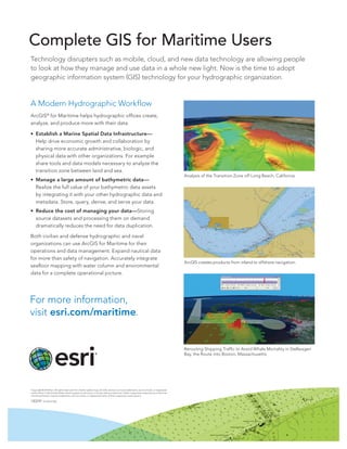
  • 1. Complete GIS for Maritime Users Technology disrupters such as mobile, cloud, and new data technology are allowing people to look at how they manage and use data in a whole new light. Now is the time to adopt geographic information system (GIS) technology for your hydrographic organization. A Modern Hydrographic Workflow ArcGIS® for Maritime helps hydrographic offices create, analyze, and produce more with their data. • Establish a Marine Spatial Data Infrastructure— Help drive economic growth and collaboration by sharing more accurate administrative, biologic, and physical data with other organizations. For example share tools and data models necessary to analyze the transition zone between land and sea. Analysis of the Transition Zone off Long Beach, California • Manage a large amount of bathymetric data— Realize the full value of your bathymetric data assets by integrating it with your other hydrographic data and metadata. Store, query, derive, and serve your data. • Reduce the cost of managing your data—Storing source datasets and processing them on demand dramatically reduces the need for data duplication. Both civilian and defense hydrographic and naval organizations can use ArcGIS for Maritime for their operations and data management. Expand nautical data for more than safety of navigation. Accurately integrate ArcGIS creates products from inland to offshore navigation. seafloor mapping with water column and environmental data for a complete operational picture. For more information, visit esri.com/maritime. Rerouting Shipping Traffic to Avoid Whale Mortality in Stellwagen Bay, the Route into Boston, Massachusetts Copyright © 2012 Esri. All rights reserved. Esri, the Esri globe logo, ArcGIS, and esri.com are trademarks, service marks, or registered marks of Esri in the United States, the European Community, or certain other jurisdictions. Other companies and products or services mentioned herein may be trademarks, service marks, or registered marks of their respective mark owners. 130259 Esri5C4/12ek