

Empfohlen
Weitere ähnliche Inhalte
Ähnlich wie Esri US Data Fact Sheet
Ähnlich wie Esri US Data Fact Sheet (20)
Mehr von Esri
Mehr von Esri (20)
Kürzlich hochgeladen
Kürzlich hochgeladen (20)
Esri US Data Fact Sheet
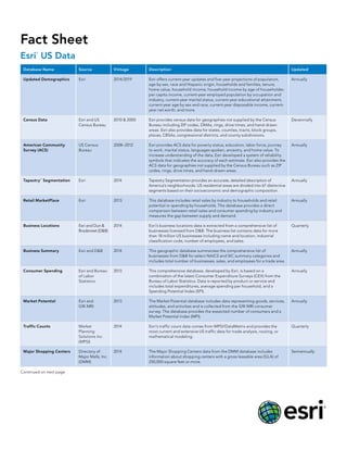
- 1. Fact Sheet Esri ® US Data Database Name Source Vintage Description Updated Updated Demographics Esri 2014/2019 Esri offers current-year updates and five-year projections of population, age by sex, race and Hispanic origin, households and families, tenure, home value, household income, household income by age of householder, per capita income, current-year employed population by occupation and industry, current-year marital status, current-year educational attainment, current-year age by sex and race, current-year disposable income, current- year net worth, and more. Annually Census Data Esri and US Census Bureau 2010 & 2000 Esri provides census data for geographies not supplied by the Census Bureau including ZIP codes, DMAs, rings, drive times, and hand-drawn areas. Esri also provides data for states, counties, tracts, block groups, places, CBSAs, congressional districts, and county subdivisions. Decennially American Community Survey (ACS) US Census Bureau 2008–2012 Esri provides ACS data for poverty status, education, labor force, journey to work, marital status, languages spoken, ancestry, and home value. To increase understanding of the data, Esri developed a system of reliability symbols that indicates the accuracy of each estimate. Esri also provides the ACS data for geographies not supplied by the Census Bureau such as ZIP codes, rings, drive times, and hand-drawn areas. Annually Tapestry™ Segmentation Esri 2014 Tapestry Segmentation provides an accurate, detailed description of America’s neighborhoods. US residential areas are divided into 67 distinctive segments based on their socioeconomic and demographic composition. Annually Retail MarketPlace Esri 2013 This database includes retail sales by industry to households and retail potential or spending by households. The database provides a direct comparison between retail sales and consumer spending by industry and measures the gap between supply and demand. Annually Business Locations Esri and Dun & Bradstreet (D&B) 2014 Esri’s business locations data is extracted from a comprehensive list of businesses licensed from D&B. The business list contains data for more than 18 million US businesses including name and location, industrial classification code, number of employees, and sales. Quarterly Business Summary Esri and D&B 2014 This geographic database summarizes the comprehensive list of businesses from D&B for select NAICS and SIC summary categories and includes total number of businesses, sales, and employees for a trade area. Annually Consumer Spending Esri and Bureau of Labor Statistics 2013 This comprehensive database, developed by Esri, is based on a combination of the latest Consumer Expenditure Surveys (CEX) from the Bureau of Labor Statistics. Data is reported by product or service and includes total expenditures, average spending per household, and a Spending Potential Index (SPI). Annually Market Potential Esri and GfK MRI 2013 The Market Potential database includes data representing goods, services, attitudes, and activities and is collected from the GfK MRI consumer survey. The database provides the expected number of consumers and a Market Potential Index (MPI). Annually Traffic Counts Market Planning Solutions Inc. (MPSI) 2014 Esri’s traffic count data comes from MPSI/DataMetrix and provides the most current and extensive US traffic data for trade analysis, routing, or mathematical modeling. Quarterly Major Shopping Centers Directory of Major Malls, Inc. (DMM) 2014 The Major Shopping Centers data from the DMM database includes information about shopping centers with a gross leasable area (GLA) of 250,000 square feet or more. Semiannually Continued on next page
- 2. July 2014 For more information about Esri’s data products, call 1-800-447-9778 or visit esri.com/bizdata. Copyright © 2014 Esri. All rights reserved. Esri, the Esri globe logo, Tapestry, ArcGIS, GeoEnrichment, and esri.com are trademarks, service marks, or registered marks of Esri in the United States, the European Community, or certain other jurisdictions. Other companies and products or services mentioned herein may be trademarks, service marks, or registered marks of their respective mark owners. G64773 7/14ms Fact Sheet Esri ® US Data Database Name Source Vintage Description Updated Bank Branches RPM Consulting 2013 Esri’s Bank Branches database incorporates information from the BranchInfoTM data created by RPM Consulting. Detailed information about every bank location in the United States is carefully standardized and address-matched to provide branch-level information by institution and site over a five-year period. Annually Banking Potential RPM Consulting 2013 MarketBankTM data from RPM Consulting is the source of Esri’s Banking Potential database. This information estimates market penetration and potential for 15 savings, investment, and lending products for every block group in the United States. Annually Crime Indexes Applied Geographic Solutions (AGS) 2013 Esri’s Crime Indexes data incorporates information from the AGS national CrimeRisk database that is based on an extensive analysis of several years of crime incidents reported by most US law enforcement jurisdictions. The Crime Indexes database includes standardized indexes for a range of serious crimes against both persons and property. The data is available at multiple geographies down to the block group level. Semiannually Esri US Demographics are available across the ArcGIS® platform, offering a comprehensive set of demographic, lifestyle, spending, and business data for mapping and analysis purposes. Esri US Demographics can be accessed through web maps and GeoEnrichmentSM services, which include infographics, data enrichment, and reports. Note: Vintages noted are for data orders; however, these vintages may differ in software and online products.