SlideShare ist ein Scribd-Unternehmen logo
1 von 2
Downloaden Sie, um offline zu lesen
Esri®
Geoportal Server
Aggregate geospatial resources for improved
discovery, use, and collaboration.
Esri®
Geoportal Server is an open source product that
enables discovery and use of geospatial resources includ-
ing datasets, rasters, and web services. It helps organiza-
tions manage and publish metadata for their geospatial
resources so users can discover and connect to those
resources. Geoportal Server supports standards-based
clearinghouse and metadata discovery applications.
Geoportal Server was released under the Apache™
2.0
license, which allows developers to freely customize and
redistribute the software.
With Geoportal Server, you can do
the following:
•	 Reduce time and redundancy of data production by
connecting geospatial data and service producers with
consumers
•	 Maintain data integrity by allowing organizations to
easily share the authoritative version of data among users
•	 Enable easy search and discovery of existing geospatial
data and services by allowing users to create and manage
descriptions of their geospatial resources and supporting
easy-to-use, sophisticated data discovery technologies
NOAA National Oceanographic Data Center (NODC) provides long-
term stewardship and preservation of ocean data, archiving more
than 25,000 data collections from ships, buoys, satellites, numerical
models, and a wide variety of other in-water sensors.
The City of Raleigh, NC, Geoportal is one part of the Open Raleigh
Initiative, which makes it easier for citizens to interact with city
government.
esri.com/geoportal
Copyright © 2014 Esri. All rights reserved. Esri, the Esri globe logo, ArcGIS, and esri.com are trademarks, service marks, or registered
marks of Esri in the United States, the European Community, or certain other jurisdictions. Other companies and products or services
mentioned herein may be trademarks, service marks, or registered marks of their respective mark owners.
142960 ESRI5C8/14ek-ca
Key Features of Esri Geoportal Server
Esri Geoportal Server helps you build and administer a
geoportal website where data producers can register their
geospatial resources for users to discover and consume.
Esri Geoportal Server
•	 Supports international data and technology standards,
such as ISO®
, OGC®
, FGDC, INSPIRE, and W3C®
•	 Catalogs existing GIS resources regardless of location
or type
•	 Facilitates discovery of GIS resources with the
customizable geoportal web interface
•	 Integrates with Portal for ArcGIS®
, ArcGISSM
Online, and
ArcGIS for Desktop for streamlined interoperability
across the ArcGIS Platform
•	 Synchronizes content from other catalogs and
geoportals
•	 Supports REST, GeoRSS, OpenSearch, CSW, ATOM™
,
GeoJSON, KML, and HTML to expose content from the
catalog service to external clients
•	 Integrates with third-party content management
systems, portal frameworks, and authentication systems
Open Options with Open Source
The free open source model for Geoportal Server makes it
easy for you to use and customize multiple geoportals. You
can deploy a geoportal for the following:
•	 Personal geospatial data management to aggregate
your local datasets and public or enterprise services to
manage and browse all your resources in one location
•	 Collaboration with other departments and
organizations for general or project-specific data sharing
•	 Enterprise geospatial data management to manage all
your organization’s geospatial resources in one location
•	 Communication with the public via the geoportal’s
intuitive web interface
Geoportal of Lombardy connects the geospatial data from the
region’s many organizations in one central location.
Southeast Alaska GIS Library allows users to search its geospatial
database, preview key metadata fields, assess spatial extents, and link to
GIS Library’s website to download the datasets.
esri.com/geoportal

Weitere ähnliche Inhalte

Was ist angesagt?

Arcadis - Improving Ground Engineering Data Flows - Smart Infrastructure - AC18
Arcadis - Improving Ground Engineering Data Flows - Smart Infrastructure - AC18Arcadis - Improving Ground Engineering Data Flows - Smart Infrastructure - AC18
Arcadis - Improving Ground Engineering Data Flows - Smart Infrastructure - AC18Esri UK
 
Esriuk_track4_bird_life
Esriuk_track4_bird_lifeEsriuk_track4_bird_life
Esriuk_track4_bird_lifeEsri UK
 
Esri and Airbus Defense & Space
Esri and Airbus Defense & SpaceEsri and Airbus Defense & Space
Esri and Airbus Defense & SpaceEsri
 
Arcgis for Server
Arcgis for ServerArcgis for Server
Arcgis for ServerEsri
 
Esri Scotland Conf 2016 Glasgow City Council
Esri Scotland Conf 2016   Glasgow City CouncilEsri Scotland Conf 2016   Glasgow City Council
Esri Scotland Conf 2016 Glasgow City CouncilEsri UK
 
Day1 concurrent fellows
Day1 concurrent fellowsDay1 concurrent fellows
Day1 concurrent fellowstoptrails
 
StreetMap Premium for ArcGIS
StreetMap Premium for ArcGISStreetMap Premium for ArcGIS
StreetMap Premium for ArcGISEsri
 
Data Sharing and Collaboration
Data Sharing and CollaborationData Sharing and Collaboration
Data Sharing and CollaborationMarten Hogeweg
 
What's New in the ArcGIS Platform - Smart Education - Higher - AC18
What's New in the ArcGIS Platform - Smart Education - Higher - AC18What's New in the ArcGIS Platform - Smart Education - Higher - AC18
What's New in the ArcGIS Platform - Smart Education - Higher - AC18Esri UK
 
Trends and news for GIS in petroleum
Trends and news for GIS in petroleumTrends and news for GIS in petroleum
Trends and news for GIS in petroleumGeodata AS
 
Enhance your maps with arcade - Esri UK
Enhance your maps with arcade - Esri UKEnhance your maps with arcade - Esri UK
Enhance your maps with arcade - Esri UKEsri UK
 
Introduction to WebGIS- Esri norsk BK 2014
Introduction to WebGIS- Esri norsk BK 2014Introduction to WebGIS- Esri norsk BK 2014
Introduction to WebGIS- Esri norsk BK 2014Geodata AS
 
Augmented Reality Using Mobile Mapping
Augmented Reality Using Mobile MappingAugmented Reality Using Mobile Mapping
Augmented Reality Using Mobile MappingEsri
 
Staging the Enterprise on ArcGIS Online
Staging the Enterprise on ArcGIS OnlineStaging the Enterprise on ArcGIS Online
Staging the Enterprise on ArcGIS OnlineMichael Olkin
 
Esriuk_track5_mobile_solutions
Esriuk_track5_mobile_solutionsEsriuk_track5_mobile_solutions
Esriuk_track5_mobile_solutionsEsri UK
 
Working with arcgis online
Working with arcgis onlineWorking with arcgis online
Working with arcgis onlinezmmin383
 

Was ist angesagt? (20)

Arcadis - Improving Ground Engineering Data Flows - Smart Infrastructure - AC18
Arcadis - Improving Ground Engineering Data Flows - Smart Infrastructure - AC18Arcadis - Improving Ground Engineering Data Flows - Smart Infrastructure - AC18
Arcadis - Improving Ground Engineering Data Flows - Smart Infrastructure - AC18
 
Esriuk_track4_bird_life
Esriuk_track4_bird_lifeEsriuk_track4_bird_life
Esriuk_track4_bird_life
 
Esri and Airbus Defense & Space
Esri and Airbus Defense & SpaceEsri and Airbus Defense & Space
Esri and Airbus Defense & Space
 
Arcgis for Server
Arcgis for ServerArcgis for Server
Arcgis for Server
 
Day4_WebGIS
Day4_WebGISDay4_WebGIS
Day4_WebGIS
 
Esri Scotland Conf 2016 Glasgow City Council
Esri Scotland Conf 2016   Glasgow City CouncilEsri Scotland Conf 2016   Glasgow City Council
Esri Scotland Conf 2016 Glasgow City Council
 
Day1 concurrent fellows
Day1 concurrent fellowsDay1 concurrent fellows
Day1 concurrent fellows
 
StreetMap Premium for ArcGIS
StreetMap Premium for ArcGISStreetMap Premium for ArcGIS
StreetMap Premium for ArcGIS
 
High Accuracy Data Collection with Esri's Collector App
High Accuracy Data Collection with Esri's Collector AppHigh Accuracy Data Collection with Esri's Collector App
High Accuracy Data Collection with Esri's Collector App
 
Data Sharing and Collaboration
Data Sharing and CollaborationData Sharing and Collaboration
Data Sharing and Collaboration
 
What's New in the ArcGIS Platform - Smart Education - Higher - AC18
What's New in the ArcGIS Platform - Smart Education - Higher - AC18What's New in the ArcGIS Platform - Smart Education - Higher - AC18
What's New in the ArcGIS Platform - Smart Education - Higher - AC18
 
Collector for ArcGIS
Collector for ArcGISCollector for ArcGIS
Collector for ArcGIS
 
Trends and news for GIS in petroleum
Trends and news for GIS in petroleumTrends and news for GIS in petroleum
Trends and news for GIS in petroleum
 
Enhance your maps with arcade - Esri UK
Enhance your maps with arcade - Esri UKEnhance your maps with arcade - Esri UK
Enhance your maps with arcade - Esri UK
 
Introduction to WebGIS- Esri norsk BK 2014
Introduction to WebGIS- Esri norsk BK 2014Introduction to WebGIS- Esri norsk BK 2014
Introduction to WebGIS- Esri norsk BK 2014
 
Augmented Reality Using Mobile Mapping
Augmented Reality Using Mobile MappingAugmented Reality Using Mobile Mapping
Augmented Reality Using Mobile Mapping
 
Staging the Enterprise on ArcGIS Online
Staging the Enterprise on ArcGIS OnlineStaging the Enterprise on ArcGIS Online
Staging the Enterprise on ArcGIS Online
 
AWS Customer Presentation- Esri
AWS Customer Presentation- EsriAWS Customer Presentation- Esri
AWS Customer Presentation- Esri
 
Esriuk_track5_mobile_solutions
Esriuk_track5_mobile_solutionsEsriuk_track5_mobile_solutions
Esriuk_track5_mobile_solutions
 
Working with arcgis online
Working with arcgis onlineWorking with arcgis online
Working with arcgis online
 

Ähnlich wie Esri Geoportal Server

Esri Geoportal Server
Esri Geoportal ServerEsri Geoportal Server
Esri Geoportal ServerEsri
 
Esri Geoportal Server
Esri Geoportal ServerEsri Geoportal Server
Esri Geoportal ServerEsri
 
Implementing an Open Source Spatiotemporal Search Platform for Spatial Data I...
Implementing an Open Source Spatiotemporal Search Platform for Spatial Data I...Implementing an Open Source Spatiotemporal Search Platform for Spatial Data I...
Implementing an Open Source Spatiotemporal Search Platform for Spatial Data I...Paolo Corti
 
Free remote sensing and GIS data
Free remote sensing and GIS dataFree remote sensing and GIS data
Free remote sensing and GIS dataNopphawanTamkuan
 
Validation of services, data and metadata
Validation of services, data and metadataValidation of services, data and metadata
Validation of services, data and metadataLuis Bermudez
 
Webinar: What's new in CDAP 3.5?
Webinar: What's new in CDAP 3.5?Webinar: What's new in CDAP 3.5?
Webinar: What's new in CDAP 3.5?Cask Data
 
Technical integration of data repositories status and challenges
Technical integration of data repositories status and challengesTechnical integration of data repositories status and challenges
Technical integration of data repositories status and challengesvty
 
Apex 42-new-features-1867076
Apex 42-new-features-1867076Apex 42-new-features-1867076
Apex 42-new-features-1867076Gorava Prakash
 
Gi2013 vohnout&team-enviro grids
Gi2013 vohnout&team-enviro gridsGi2013 vohnout&team-enviro grids
Gi2013 vohnout&team-enviro gridsKarel Charvat
 
GI2013 ppt vohnout&team-enviro_grids
GI2013 ppt vohnout&team-enviro_gridsGI2013 ppt vohnout&team-enviro_grids
GI2013 ppt vohnout&team-enviro_gridsIGN Vorstand
 
A Quick Survey of Open Source Software for PH Organizations, a paper by Massi...
A Quick Survey of Open Source Software for PH Organizations, a paper by Massi...A Quick Survey of Open Source Software for PH Organizations, a paper by Massi...
A Quick Survey of Open Source Software for PH Organizations, a paper by Massi...InSTEDD
 
Open Data Portals: 9 Solutions and How they Compare
Open Data Portals: 9 Solutions and How they CompareOpen Data Portals: 9 Solutions and How they Compare
Open Data Portals: 9 Solutions and How they CompareSafe Software
 
Integrating PostGIS in Web Applications
Integrating PostGIS in Web ApplicationsIntegrating PostGIS in Web Applications
Integrating PostGIS in Web ApplicationsCommand Prompt., Inc
 
WSO2 Intro Webinar - Scale your business with the cloud enabled WSO2 Applica...
WSO2 Intro Webinar -  Scale your business with the cloud enabled WSO2 Applica...WSO2 Intro Webinar -  Scale your business with the cloud enabled WSO2 Applica...
WSO2 Intro Webinar - Scale your business with the cloud enabled WSO2 Applica...WSO2
 
2013 Vendor, MapQuest Plugins for Leaflet by Jonathan Harahush
2013 Vendor, MapQuest Plugins for Leaflet by Jonathan Harahush2013 Vendor, MapQuest Plugins for Leaflet by Jonathan Harahush
2013 Vendor, MapQuest Plugins for Leaflet by Jonathan HarahushGIS in the Rockies
 
Esri-Supported OGC/ISO Standards
Esri-Supported OGC/ISO StandardsEsri-Supported OGC/ISO Standards
Esri-Supported OGC/ISO StandardsEsri
 
LoCloud: overview of LoCloud Services
LoCloud: overview of LoCloud ServicesLoCloud: overview of LoCloud Services
LoCloud: overview of LoCloud Serviceslocloud
 
GIS Standards and Interoperability
GIS Standards and InteroperabilityGIS Standards and Interoperability
GIS Standards and InteroperabilityNasr Khashoggi
 
ELIXIR Competence Centre in EOSC-hub
ELIXIR Competence Centre in EOSC-hubELIXIR Competence Centre in EOSC-hub
ELIXIR Competence Centre in EOSC-hubEOSC-hub project
 

Ähnlich wie Esri Geoportal Server (20)

Esri Geoportal Server
Esri Geoportal ServerEsri Geoportal Server
Esri Geoportal Server
 
Esri Geoportal Server
Esri Geoportal ServerEsri Geoportal Server
Esri Geoportal Server
 
Implementing an Open Source Spatiotemporal Search Platform for Spatial Data I...
Implementing an Open Source Spatiotemporal Search Platform for Spatial Data I...Implementing an Open Source Spatiotemporal Search Platform for Spatial Data I...
Implementing an Open Source Spatiotemporal Search Platform for Spatial Data I...
 
Free remote sensing and GIS data
Free remote sensing and GIS dataFree remote sensing and GIS data
Free remote sensing and GIS data
 
Geohosting
GeohostingGeohosting
Geohosting
 
Validation of services, data and metadata
Validation of services, data and metadataValidation of services, data and metadata
Validation of services, data and metadata
 
Webinar: What's new in CDAP 3.5?
Webinar: What's new in CDAP 3.5?Webinar: What's new in CDAP 3.5?
Webinar: What's new in CDAP 3.5?
 
Technical integration of data repositories status and challenges
Technical integration of data repositories status and challengesTechnical integration of data repositories status and challenges
Technical integration of data repositories status and challenges
 
Apex 42-new-features-1867076
Apex 42-new-features-1867076Apex 42-new-features-1867076
Apex 42-new-features-1867076
 
Gi2013 vohnout&team-enviro grids
Gi2013 vohnout&team-enviro gridsGi2013 vohnout&team-enviro grids
Gi2013 vohnout&team-enviro grids
 
GI2013 ppt vohnout&team-enviro_grids
GI2013 ppt vohnout&team-enviro_gridsGI2013 ppt vohnout&team-enviro_grids
GI2013 ppt vohnout&team-enviro_grids
 
A Quick Survey of Open Source Software for PH Organizations, a paper by Massi...
A Quick Survey of Open Source Software for PH Organizations, a paper by Massi...A Quick Survey of Open Source Software for PH Organizations, a paper by Massi...
A Quick Survey of Open Source Software for PH Organizations, a paper by Massi...
 
Open Data Portals: 9 Solutions and How they Compare
Open Data Portals: 9 Solutions and How they CompareOpen Data Portals: 9 Solutions and How they Compare
Open Data Portals: 9 Solutions and How they Compare
 
Integrating PostGIS in Web Applications
Integrating PostGIS in Web ApplicationsIntegrating PostGIS in Web Applications
Integrating PostGIS in Web Applications
 
WSO2 Intro Webinar - Scale your business with the cloud enabled WSO2 Applica...
WSO2 Intro Webinar -  Scale your business with the cloud enabled WSO2 Applica...WSO2 Intro Webinar -  Scale your business with the cloud enabled WSO2 Applica...
WSO2 Intro Webinar - Scale your business with the cloud enabled WSO2 Applica...
 
2013 Vendor, MapQuest Plugins for Leaflet by Jonathan Harahush
2013 Vendor, MapQuest Plugins for Leaflet by Jonathan Harahush2013 Vendor, MapQuest Plugins for Leaflet by Jonathan Harahush
2013 Vendor, MapQuest Plugins for Leaflet by Jonathan Harahush
 
Esri-Supported OGC/ISO Standards
Esri-Supported OGC/ISO StandardsEsri-Supported OGC/ISO Standards
Esri-Supported OGC/ISO Standards
 
LoCloud: overview of LoCloud Services
LoCloud: overview of LoCloud ServicesLoCloud: overview of LoCloud Services
LoCloud: overview of LoCloud Services
 
GIS Standards and Interoperability
GIS Standards and InteroperabilityGIS Standards and Interoperability
GIS Standards and Interoperability
 
ELIXIR Competence Centre in EOSC-hub
ELIXIR Competence Centre in EOSC-hubELIXIR Competence Centre in EOSC-hub
ELIXIR Competence Centre in EOSC-hub
 

Mehr von Esri

INIA- CISA: Análisis de las amenazas en la fauna silvestre
INIA- CISA: Análisis de las amenazas en la fauna silvestreINIA- CISA: Análisis de las amenazas en la fauna silvestre
INIA- CISA: Análisis de las amenazas en la fauna silvestreEsri
 
Aena Aeropuerto Adolfo Suárez-Barajas crea potentes aplicaciones para sus cli...
Aena Aeropuerto Adolfo Suárez-Barajas crea potentes aplicaciones para sus cli...Aena Aeropuerto Adolfo Suárez-Barajas crea potentes aplicaciones para sus cli...
Aena Aeropuerto Adolfo Suárez-Barajas crea potentes aplicaciones para sus cli...Esri
 
Plataforma Smart City de Móstoles
Plataforma Smart City de MóstolesPlataforma Smart City de Móstoles
Plataforma Smart City de MóstolesEsri
 
ArcGIS Online para Organizaciones
ArcGIS Online para OrganizacionesArcGIS Online para Organizaciones
ArcGIS Online para OrganizacionesEsri
 
Molina de Segura se convierte en una smart city
Molina de Segura se convierte en una smart cityMolina de Segura se convierte en una smart city
Molina de Segura se convierte en una smart cityEsri
 
GIS-Based Web Services Provide Rapid Analysis and Dissemination of Maritime Data
GIS-Based Web Services Provide Rapid Analysis and Dissemination of Maritime DataGIS-Based Web Services Provide Rapid Analysis and Dissemination of Maritime Data
GIS-Based Web Services Provide Rapid Analysis and Dissemination of Maritime DataEsri
 
An Effective Tool for Drinking Water Protection
An Effective Tool for Drinking Water ProtectionAn Effective Tool for Drinking Water Protection
An Effective Tool for Drinking Water ProtectionEsri
 
Data Appliance for ArcGIS
Data Appliance for ArcGISData Appliance for ArcGIS
Data Appliance for ArcGISEsri
 
Esri and BlackBridge
Esri and BlackBridgeEsri and BlackBridge
Esri and BlackBridgeEsri
 
Esri and AccuWeather
Esri and AccuWeatherEsri and AccuWeather
Esri and AccuWeatherEsri
 
Esri US Data Fact Sheet
Esri US Data Fact SheetEsri US Data Fact Sheet
Esri US Data Fact SheetEsri
 
ArcGIS for the Military--Maritime Operations
ArcGIS for the Military--Maritime OperationsArcGIS for the Military--Maritime Operations
ArcGIS for the Military--Maritime OperationsEsri
 
ArcGIS GeoEvent Extension for Server
ArcGIS GeoEvent Extension for ServerArcGIS GeoEvent Extension for Server
ArcGIS GeoEvent Extension for ServerEsri
 
The NATO Core Geographic Services System
The NATO Core Geographic Services SystemThe NATO Core Geographic Services System
The NATO Core Geographic Services SystemEsri
 
ArcGIS for Desktop Tips and Shortcuts
ArcGIS for Desktop Tips and ShortcutsArcGIS for Desktop Tips and Shortcuts
ArcGIS for Desktop Tips and ShortcutsEsri
 
ArcGIS Online
ArcGIS OnlineArcGIS Online
ArcGIS OnlineEsri
 
ArcGIS: A Platform for Intelligent 3D Imagery
ArcGIS: A Platform for Intelligent 3D ImageryArcGIS: A Platform for Intelligent 3D Imagery
ArcGIS: A Platform for Intelligent 3D ImageryEsri
 
Location Analytics for Banking
Location Analytics for BankingLocation Analytics for Banking
Location Analytics for BankingEsri
 
Esri CityEngine
Esri CityEngineEsri CityEngine
Esri CityEngineEsri
 
ArcGIS
ArcGISArcGIS
ArcGISEsri
 

Mehr von Esri (20)

INIA- CISA: Análisis de las amenazas en la fauna silvestre
INIA- CISA: Análisis de las amenazas en la fauna silvestreINIA- CISA: Análisis de las amenazas en la fauna silvestre
INIA- CISA: Análisis de las amenazas en la fauna silvestre
 
Aena Aeropuerto Adolfo Suárez-Barajas crea potentes aplicaciones para sus cli...
Aena Aeropuerto Adolfo Suárez-Barajas crea potentes aplicaciones para sus cli...Aena Aeropuerto Adolfo Suárez-Barajas crea potentes aplicaciones para sus cli...
Aena Aeropuerto Adolfo Suárez-Barajas crea potentes aplicaciones para sus cli...
 
Plataforma Smart City de Móstoles
Plataforma Smart City de MóstolesPlataforma Smart City de Móstoles
Plataforma Smart City de Móstoles
 
ArcGIS Online para Organizaciones
ArcGIS Online para OrganizacionesArcGIS Online para Organizaciones
ArcGIS Online para Organizaciones
 
Molina de Segura se convierte en una smart city
Molina de Segura se convierte en una smart cityMolina de Segura se convierte en una smart city
Molina de Segura se convierte en una smart city
 
GIS-Based Web Services Provide Rapid Analysis and Dissemination of Maritime Data
GIS-Based Web Services Provide Rapid Analysis and Dissemination of Maritime DataGIS-Based Web Services Provide Rapid Analysis and Dissemination of Maritime Data
GIS-Based Web Services Provide Rapid Analysis and Dissemination of Maritime Data
 
An Effective Tool for Drinking Water Protection
An Effective Tool for Drinking Water ProtectionAn Effective Tool for Drinking Water Protection
An Effective Tool for Drinking Water Protection
 
Data Appliance for ArcGIS
Data Appliance for ArcGISData Appliance for ArcGIS
Data Appliance for ArcGIS
 
Esri and BlackBridge
Esri and BlackBridgeEsri and BlackBridge
Esri and BlackBridge
 
Esri and AccuWeather
Esri and AccuWeatherEsri and AccuWeather
Esri and AccuWeather
 
Esri US Data Fact Sheet
Esri US Data Fact SheetEsri US Data Fact Sheet
Esri US Data Fact Sheet
 
ArcGIS for the Military--Maritime Operations
ArcGIS for the Military--Maritime OperationsArcGIS for the Military--Maritime Operations
ArcGIS for the Military--Maritime Operations
 
ArcGIS GeoEvent Extension for Server
ArcGIS GeoEvent Extension for ServerArcGIS GeoEvent Extension for Server
ArcGIS GeoEvent Extension for Server
 
The NATO Core Geographic Services System
The NATO Core Geographic Services SystemThe NATO Core Geographic Services System
The NATO Core Geographic Services System
 
ArcGIS for Desktop Tips and Shortcuts
ArcGIS for Desktop Tips and ShortcutsArcGIS for Desktop Tips and Shortcuts
ArcGIS for Desktop Tips and Shortcuts
 
ArcGIS Online
ArcGIS OnlineArcGIS Online
ArcGIS Online
 
ArcGIS: A Platform for Intelligent 3D Imagery
ArcGIS: A Platform for Intelligent 3D ImageryArcGIS: A Platform for Intelligent 3D Imagery
ArcGIS: A Platform for Intelligent 3D Imagery
 
Location Analytics for Banking
Location Analytics for BankingLocation Analytics for Banking
Location Analytics for Banking
 
Esri CityEngine
Esri CityEngineEsri CityEngine
Esri CityEngine
 
ArcGIS
ArcGISArcGIS
ArcGIS
 

Kürzlich hochgeladen

TeamStation AI System Report LATAM IT Salaries 2024
TeamStation AI System Report LATAM IT Salaries 2024TeamStation AI System Report LATAM IT Salaries 2024
TeamStation AI System Report LATAM IT Salaries 2024Lonnie McRorey
 
"Debugging python applications inside k8s environment", Andrii Soldatenko
"Debugging python applications inside k8s environment", Andrii Soldatenko"Debugging python applications inside k8s environment", Andrii Soldatenko
"Debugging python applications inside k8s environment", Andrii SoldatenkoFwdays
 
"ML in Production",Oleksandr Bagan
"ML in Production",Oleksandr Bagan"ML in Production",Oleksandr Bagan
"ML in Production",Oleksandr BaganFwdays
 
Developer Data Modeling Mistakes: From Postgres to NoSQL
Developer Data Modeling Mistakes: From Postgres to NoSQLDeveloper Data Modeling Mistakes: From Postgres to NoSQL
Developer Data Modeling Mistakes: From Postgres to NoSQLScyllaDB
 
The Role of FIDO in a Cyber Secure Netherlands: FIDO Paris Seminar.pptx
The Role of FIDO in a Cyber Secure Netherlands: FIDO Paris Seminar.pptxThe Role of FIDO in a Cyber Secure Netherlands: FIDO Paris Seminar.pptx
The Role of FIDO in a Cyber Secure Netherlands: FIDO Paris Seminar.pptxLoriGlavin3
 
DevEX - reference for building teams, processes, and platforms
DevEX - reference for building teams, processes, and platformsDevEX - reference for building teams, processes, and platforms
DevEX - reference for building teams, processes, and platformsSergiu Bodiu
 
Generative AI for Technical Writer or Information Developers
Generative AI for Technical Writer or Information DevelopersGenerative AI for Technical Writer or Information Developers
Generative AI for Technical Writer or Information DevelopersRaghuram Pandurangan
 
Unraveling Multimodality with Large Language Models.pdf
Unraveling Multimodality with Large Language Models.pdfUnraveling Multimodality with Large Language Models.pdf
Unraveling Multimodality with Large Language Models.pdfAlex Barbosa Coqueiro
 
Transcript: New from BookNet Canada for 2024: Loan Stars - Tech Forum 2024
Transcript: New from BookNet Canada for 2024: Loan Stars - Tech Forum 2024Transcript: New from BookNet Canada for 2024: Loan Stars - Tech Forum 2024
Transcript: New from BookNet Canada for 2024: Loan Stars - Tech Forum 2024BookNet Canada
 
unit 4 immunoblotting technique complete.pptx
unit 4 immunoblotting technique complete.pptxunit 4 immunoblotting technique complete.pptx
unit 4 immunoblotting technique complete.pptxBkGupta21
 
New from BookNet Canada for 2024: Loan Stars - Tech Forum 2024
New from BookNet Canada for 2024: Loan Stars - Tech Forum 2024New from BookNet Canada for 2024: Loan Stars - Tech Forum 2024
New from BookNet Canada for 2024: Loan Stars - Tech Forum 2024BookNet Canada
 
"Subclassing and Composition – A Pythonic Tour of Trade-Offs", Hynek Schlawack
"Subclassing and Composition – A Pythonic Tour of Trade-Offs", Hynek Schlawack"Subclassing and Composition – A Pythonic Tour of Trade-Offs", Hynek Schlawack
"Subclassing and Composition – A Pythonic Tour of Trade-Offs", Hynek SchlawackFwdays
 
Use of FIDO in the Payments and Identity Landscape: FIDO Paris Seminar.pptx
Use of FIDO in the Payments and Identity Landscape: FIDO Paris Seminar.pptxUse of FIDO in the Payments and Identity Landscape: FIDO Paris Seminar.pptx
Use of FIDO in the Payments and Identity Landscape: FIDO Paris Seminar.pptxLoriGlavin3
 
Advanced Computer Architecture – An Introduction
Advanced Computer Architecture – An IntroductionAdvanced Computer Architecture – An Introduction
Advanced Computer Architecture – An IntroductionDilum Bandara
 
Ensuring Technical Readiness For Copilot in Microsoft 365
Ensuring Technical Readiness For Copilot in Microsoft 365Ensuring Technical Readiness For Copilot in Microsoft 365
Ensuring Technical Readiness For Copilot in Microsoft 3652toLead Limited
 
Artificial intelligence in cctv survelliance.pptx
Artificial intelligence in cctv survelliance.pptxArtificial intelligence in cctv survelliance.pptx
Artificial intelligence in cctv survelliance.pptxhariprasad279825
 
How AI, OpenAI, and ChatGPT impact business and software.
How AI, OpenAI, and ChatGPT impact business and software.How AI, OpenAI, and ChatGPT impact business and software.
How AI, OpenAI, and ChatGPT impact business and software.Curtis Poe
 
DevoxxFR 2024 Reproducible Builds with Apache Maven
DevoxxFR 2024 Reproducible Builds with Apache MavenDevoxxFR 2024 Reproducible Builds with Apache Maven
DevoxxFR 2024 Reproducible Builds with Apache MavenHervé Boutemy
 
What is DBT - The Ultimate Data Build Tool.pdf
What is DBT - The Ultimate Data Build Tool.pdfWhat is DBT - The Ultimate Data Build Tool.pdf
What is DBT - The Ultimate Data Build Tool.pdfMounikaPolabathina
 
Merck Moving Beyond Passwords: FIDO Paris Seminar.pptx
Merck Moving Beyond Passwords: FIDO Paris Seminar.pptxMerck Moving Beyond Passwords: FIDO Paris Seminar.pptx
Merck Moving Beyond Passwords: FIDO Paris Seminar.pptxLoriGlavin3
 

Kürzlich hochgeladen (20)

TeamStation AI System Report LATAM IT Salaries 2024
TeamStation AI System Report LATAM IT Salaries 2024TeamStation AI System Report LATAM IT Salaries 2024
TeamStation AI System Report LATAM IT Salaries 2024
 
"Debugging python applications inside k8s environment", Andrii Soldatenko
"Debugging python applications inside k8s environment", Andrii Soldatenko"Debugging python applications inside k8s environment", Andrii Soldatenko
"Debugging python applications inside k8s environment", Andrii Soldatenko
 
"ML in Production",Oleksandr Bagan
"ML in Production",Oleksandr Bagan"ML in Production",Oleksandr Bagan
"ML in Production",Oleksandr Bagan
 
Developer Data Modeling Mistakes: From Postgres to NoSQL
Developer Data Modeling Mistakes: From Postgres to NoSQLDeveloper Data Modeling Mistakes: From Postgres to NoSQL
Developer Data Modeling Mistakes: From Postgres to NoSQL
 
The Role of FIDO in a Cyber Secure Netherlands: FIDO Paris Seminar.pptx
The Role of FIDO in a Cyber Secure Netherlands: FIDO Paris Seminar.pptxThe Role of FIDO in a Cyber Secure Netherlands: FIDO Paris Seminar.pptx
The Role of FIDO in a Cyber Secure Netherlands: FIDO Paris Seminar.pptx
 
DevEX - reference for building teams, processes, and platforms
DevEX - reference for building teams, processes, and platformsDevEX - reference for building teams, processes, and platforms
DevEX - reference for building teams, processes, and platforms
 
Generative AI for Technical Writer or Information Developers
Generative AI for Technical Writer or Information DevelopersGenerative AI for Technical Writer or Information Developers
Generative AI for Technical Writer or Information Developers
 
Unraveling Multimodality with Large Language Models.pdf
Unraveling Multimodality with Large Language Models.pdfUnraveling Multimodality with Large Language Models.pdf
Unraveling Multimodality with Large Language Models.pdf
 
Transcript: New from BookNet Canada for 2024: Loan Stars - Tech Forum 2024
Transcript: New from BookNet Canada for 2024: Loan Stars - Tech Forum 2024Transcript: New from BookNet Canada for 2024: Loan Stars - Tech Forum 2024
Transcript: New from BookNet Canada for 2024: Loan Stars - Tech Forum 2024
 
unit 4 immunoblotting technique complete.pptx
unit 4 immunoblotting technique complete.pptxunit 4 immunoblotting technique complete.pptx
unit 4 immunoblotting technique complete.pptx
 
New from BookNet Canada for 2024: Loan Stars - Tech Forum 2024
New from BookNet Canada for 2024: Loan Stars - Tech Forum 2024New from BookNet Canada for 2024: Loan Stars - Tech Forum 2024
New from BookNet Canada for 2024: Loan Stars - Tech Forum 2024
 
"Subclassing and Composition – A Pythonic Tour of Trade-Offs", Hynek Schlawack
"Subclassing and Composition – A Pythonic Tour of Trade-Offs", Hynek Schlawack"Subclassing and Composition – A Pythonic Tour of Trade-Offs", Hynek Schlawack
"Subclassing and Composition – A Pythonic Tour of Trade-Offs", Hynek Schlawack
 
Use of FIDO in the Payments and Identity Landscape: FIDO Paris Seminar.pptx
Use of FIDO in the Payments and Identity Landscape: FIDO Paris Seminar.pptxUse of FIDO in the Payments and Identity Landscape: FIDO Paris Seminar.pptx
Use of FIDO in the Payments and Identity Landscape: FIDO Paris Seminar.pptx
 
Advanced Computer Architecture – An Introduction
Advanced Computer Architecture – An IntroductionAdvanced Computer Architecture – An Introduction
Advanced Computer Architecture – An Introduction
 
Ensuring Technical Readiness For Copilot in Microsoft 365
Ensuring Technical Readiness For Copilot in Microsoft 365Ensuring Technical Readiness For Copilot in Microsoft 365
Ensuring Technical Readiness For Copilot in Microsoft 365
 
Artificial intelligence in cctv survelliance.pptx
Artificial intelligence in cctv survelliance.pptxArtificial intelligence in cctv survelliance.pptx
Artificial intelligence in cctv survelliance.pptx
 
How AI, OpenAI, and ChatGPT impact business and software.
How AI, OpenAI, and ChatGPT impact business and software.How AI, OpenAI, and ChatGPT impact business and software.
How AI, OpenAI, and ChatGPT impact business and software.
 
DevoxxFR 2024 Reproducible Builds with Apache Maven
DevoxxFR 2024 Reproducible Builds with Apache MavenDevoxxFR 2024 Reproducible Builds with Apache Maven
DevoxxFR 2024 Reproducible Builds with Apache Maven
 
What is DBT - The Ultimate Data Build Tool.pdf
What is DBT - The Ultimate Data Build Tool.pdfWhat is DBT - The Ultimate Data Build Tool.pdf
What is DBT - The Ultimate Data Build Tool.pdf
 
Merck Moving Beyond Passwords: FIDO Paris Seminar.pptx
Merck Moving Beyond Passwords: FIDO Paris Seminar.pptxMerck Moving Beyond Passwords: FIDO Paris Seminar.pptx
Merck Moving Beyond Passwords: FIDO Paris Seminar.pptx
 

Esri Geoportal Server

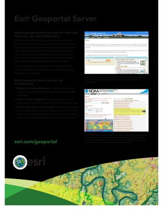
  • 1. Esri® Geoportal Server Aggregate geospatial resources for improved discovery, use, and collaboration. Esri® Geoportal Server is an open source product that enables discovery and use of geospatial resources includ- ing datasets, rasters, and web services. It helps organiza- tions manage and publish metadata for their geospatial resources so users can discover and connect to those resources. Geoportal Server supports standards-based clearinghouse and metadata discovery applications. Geoportal Server was released under the Apache™ 2.0 license, which allows developers to freely customize and redistribute the software. With Geoportal Server, you can do the following: • Reduce time and redundancy of data production by connecting geospatial data and service producers with consumers • Maintain data integrity by allowing organizations to easily share the authoritative version of data among users • Enable easy search and discovery of existing geospatial data and services by allowing users to create and manage descriptions of their geospatial resources and supporting easy-to-use, sophisticated data discovery technologies NOAA National Oceanographic Data Center (NODC) provides long- term stewardship and preservation of ocean data, archiving more than 25,000 data collections from ships, buoys, satellites, numerical models, and a wide variety of other in-water sensors. The City of Raleigh, NC, Geoportal is one part of the Open Raleigh Initiative, which makes it easier for citizens to interact with city government. esri.com/geoportal
  • 2. Copyright © 2014 Esri. All rights reserved. Esri, the Esri globe logo, ArcGIS, and esri.com are trademarks, service marks, or registered marks of Esri in the United States, the European Community, or certain other jurisdictions. Other companies and products or services mentioned herein may be trademarks, service marks, or registered marks of their respective mark owners. 142960 ESRI5C8/14ek-ca Key Features of Esri Geoportal Server Esri Geoportal Server helps you build and administer a geoportal website where data producers can register their geospatial resources for users to discover and consume. Esri Geoportal Server • Supports international data and technology standards, such as ISO® , OGC® , FGDC, INSPIRE, and W3C® • Catalogs existing GIS resources regardless of location or type • Facilitates discovery of GIS resources with the customizable geoportal web interface • Integrates with Portal for ArcGIS® , ArcGISSM Online, and ArcGIS for Desktop for streamlined interoperability across the ArcGIS Platform • Synchronizes content from other catalogs and geoportals • Supports REST, GeoRSS, OpenSearch, CSW, ATOM™ , GeoJSON, KML, and HTML to expose content from the catalog service to external clients • Integrates with third-party content management systems, portal frameworks, and authentication systems Open Options with Open Source The free open source model for Geoportal Server makes it easy for you to use and customize multiple geoportals. You can deploy a geoportal for the following: • Personal geospatial data management to aggregate your local datasets and public or enterprise services to manage and browse all your resources in one location • Collaboration with other departments and organizations for general or project-specific data sharing • Enterprise geospatial data management to manage all your organization’s geospatial resources in one location • Communication with the public via the geoportal’s intuitive web interface Geoportal of Lombardy connects the geospatial data from the region’s many organizations in one central location. Southeast Alaska GIS Library allows users to search its geospatial database, preview key metadata fields, assess spatial extents, and link to GIS Library’s website to download the datasets. esri.com/geoportal