SlideShare ist ein Scribd-Unternehmen logo
1 von 4
Downloaden Sie, um offline zu lesen
ENVI 5 Matriz de Funcionalidad

Sistemas operativos                           • ALOS PRISM                • ER Mapper ERS
                                              • ALSAT-1                   • ERDAS IMAGINE (.img)
Windows XP SP2 (Intel/AMD 32- & 64-bit)       • ASTER                     • ESRI Geodatabase Raster Dataset:
Windows Vista (Intel/AMD 32- & 64-bit)        • ATSR                        • Personal (.mdb)
Windows 7 (Intel/AMD 32- & 64-bit)            • AVHRR                       • File (.gdb)
Linux Kernel 2.6.x (Intel/AMD 32- & 64-bit)   • CARTOSAT-1                  • Enterprise (.sde)
Mac OS X 10.5.x (Intel 32- & 64-bit)          • DMSP (NOAA)               • ESRI GRID
Max OS X 10.6 (Intel 32- & 64-bit)            • ENVISAT AATSR             • GeoJP2 / GeoJ2K
Sun Solaris 10 (SPARC 32- & 64-bit)           • ENVISAT MERIS             • GeoTIFF
                                              • EROS                      • HDF4
Importación de datos                          • FORMOSAT-2                • JPEG
                                              • GeoEye-1                  • JPEG2000
Fórmatos raster:                              • IKONOS                    • NITF 2.0, 2.1 (with license)
• ADRG                                        • IRS                       • PICT
• ArcView Raster BIL                          • KOMPSAT-2                 • PCI PIX
• ASCII (x,y,z & gridded)                     • Landsat MSS, TM, ETM+     • PNG
• BigTIFF                                     • MAS-50                    • SRF
• Binary (flat)                               • MASTER                    • TIFF
• BMP                                         • MISR                      • XWD
• CADRG                                       • MODIS                     Formatos vectoriales:
• CIB                                         • NigeriaSat-1              • AutoCAD DXF
• DPPDB (with license)                        • OrbView-3                 • ENVI EVF
• DTED (levels 0, 1, 2)                       • RapidEye                  • ESRI Geodatabase Feature Class:
• ECW                                         • SeaWiFS                     • Personal (.mdb)
• ENVI Raster                                 • QuickBird                   • File (.gdb)
• ENVI Gzip Compressed                        • SPOT                        • Enterprise (.sde)
• ER Mapper ERS                               • TIMS                      • ESRI Shapefile
• ERDAS IMAGINE (.img, .ige, .lan)            • UK-DMCSat-1               Otros:
• ESRI Geodatabase Raster Dataset:            • WorldView-1               • Direct To Printer
  • Personal (.mdb)                           • WorldView-2               • Google Earth KML
  • File (.gdb)                               Sensores hiperespectro:     • MPEG
  • Enterprise (.sde)                         • AISA                      • PostScript
• ESRI GRID                                   • ARTEMIS (with license)    • VRML
• GeoJP2 / GeoJ2K                             • AVIRIS                    Chip Display To:
• GeoTIFF                                     • CASI                      • ArcMap
• HDF4                                        • HyMap                     • ENVI Raster
• HDF-EOS                                     • Hyperion                  • ESRI Geodatabase Raster Dataset
• JPEG                                        • HyperScan                 • JPEG
• JPEG2000                                    • HySpex                    • JPEG2000 / GeoJP2
• MrSID (including MG3)                       • MIVIS                     • NITF 2.0, 2.1 (with license)
• NITF 1.1, 2.0, 2.1 (with license)           • PROBE-1                   • PowerPoint PPT
• NSIF 1.0 (with license)                     • ProspecTIR                • Printer
• PCI PIX                                     Radar:                      • TIFF / GeoTIFF
• PDS                                         • AIRSAR                    Exportación de mapas a:
• PICT                                        • ALOS PALSAR               • AI
• PNG                                         • COSMO-SkyMed              • BMP
• RemoteView R-Set (with license)             • ENVISAT ASAR              • EMF
• SRF                                         • ERS                       • EPS
• SRTM DEM                                    • JERS                      • GIF
• TFRD (with license)                         • RADARSAT-1                • JPEG
• TIFF                                        • RADARSAT-2                • PDF
• USGS DOQ                                    • SIR-C / X-SAR             • PNG
• USGS DRG                                    • TOPSAR                    • Printer
• USGS Native DEM                             Conexiones remotas:         • SVG
• USGS SDTS DEM                               • IAS Server                • TIFF
• XWD                                         • JPIP
Formatos vectoriales:                         • OGC WCS
• ARC/INFO Interchange                                                    Heramientas ENVI para ArcGIS®
                                              • OGC WMS
• AutoCAD DXF                                 Spectral Libraries:         Auto-Threshold Difference Raster
• ENVI Vector File                            • ASCII                     Calculate Image Difference
• ESRI Geodatabase Feature Class:             • ENVI SLI                  Calculate Thematic Change
  • Personal (.mdb)                           • ASD Indico                Classification Raster To Vector
  • File (.gdb)                               • MRSL                      Classify With Training
  • Enterprise (.sde)                         Anotaciones:                Classify Without Training
• ESRI Layer                                  • ENVI Annotation           Cleanup Classification Raster
• ESRI Shapefile                                                          Convert Raster Format
• MapInfo MIF                                                             Detect Anomalies
• Microstation DGN                            Formatos de salida          Filter With Convolution
• USGS DLG                                    Formatos raster:            Intersect Rasters
Formatos LiDAR:                               • ArcView Raster BIL        LiDAR To Raster
• ASCII                                       • ASCII (x,y,z & gridded)   Threshold By Percentage
• LAS                                         • BMP                       Workflow Models with Cleanup
Sensores multiespectro:                       • DTED (levels 0, 1, 2)
• ADS40                                       • ENVI Raster
• ALOS AVNIR-2                                • ENVI Gzip Compressed
                                                                                                               pg. 1
Funcionalidades de Visualización                 • Merge ROIs                                   Import Ground Control Points from File
                                                 • Import ROIs from Vectors                     Orthorectification:
Chip To:                                         Output ROIs to ASCII                           • Aerial Photographs (Digital and Frame)
• File                                           ROI Save & Restore                             • ASTER
• PowerPoint                                     Reconcile ROIs between Images via              • CARTOSAT-1
• Print                                          Map Coordinates                                • Generic RPC
• ArcMap                                         ROI Growing Based on Statistics                • Generic Pushbroom Sensors
Drag/Drop from:                                                                                 • IKONOS
                                                 ROI Statistics
• ArcGIS                                                                                        • OrbView-3
• File System                                                                                   GeoEye-1
• Windows Explorer                               Preparación de datos                           WorldView & WorldView-2
• Data Manager                                   Create New Standard or Virtual Image File      FORMOSAT-2
Drag/Drop to the:                                from Existing Bands                            Kompsat-2
• Display                                        Generate Test Image                            QuickBird
• Process                                        Mask Generation From:                          SPOT 1-5
• Workflows                                      • Annotation                                   Radial Resampling
GeoLink with ArcMap                              • Image Data Values                            Rational Polynomial Coefficients
Color Mapping                                    • ROIs                                         (RPCs) Support
Color Tables:                                    • Intersection of ROIs                         Replacement Sensor Model (RSM)
• Pre-built Tables                               • Vectors                                      Real-time GPS Link
• Interactive Color Table Editor                 • NaN                                          Rotated Projections
Cursor Query for Data/Screen Value, Elevation,   Mosaic Functions:                              Save Transformation Matrix to ASCII
Map Coordinates                                  • Color Mosaic Preview                         Warp Resampling Methods:
Dynamic Overlays (unlimited displays)            • Cutline & Edge Feathering                    • Bilinear
Histogram Matching Between Displays              • Interactively Mosaic Multiple Bands, Files   • Cubic Convolution
Image Flickering and "Movies"                    • Mosaic by Pixel (Line, Sample) or Map        • Nearest Neighbor
Image Overlays:                                     Coordinates                                 Warping Methods:
• Annotation                                     • Automatic Color Balancing                    • Delaunay Triangulation
• Classification Results                         • Standard Image or Virtual Mosaic Output      • Polynomial
• Contour Lines                                  Define Spatial Subset by:                      • Rotation, Scaling, Translation (RST)
• Density (gray level) Color Slicing             • Drawing on Display
• Grid Lines                                     • File, Map Coordinates
• Regions of Interest                            • Region of Interest                           Proyección de mapas
• Vector Layers                                  • Other Image Extent                           Datum Support (90)
Interactive 2-D Scatter Plotting                 • Meta Scroll Extent                           Dozens of Prebuilt Map Projections (Examples
Interactive Histograms & Stretching:             NITF Metadata Browser                          Include):
• Arbitrary Stretching                           Rotate/Flip Data                               • Universal Transverse Mercator (UTM)
• Auto Apply Stretches                           Spatial and Spectral Subsets                   • State Plane
• Gaussian Stretching                            Storage Order (Interleave) Conversions:        • Albers Conical Equal Area
• Histogram Equalization Stretching              • BSQ, BIL, BIP                                • Lambert Conformal Conic
• Histogram Matching Between Displays            • New File or Replace Original                 • Miller Cylindrical
• Linear, Piecewise Linear Stretching            Stretch Data                                   Ellipsoid Support (35)
• Square Root Stretching                         Subsample Images                               Pseudo-Projections from RPCs and RSM
• Import/Export ASCII Look Up Tables
• User-Defined Look Up Tables
Interactive Pixel Editor                         Preprocesado y calibrado                       Vector GIS Functions
Line-of-Sight (Viewshed) Analysis                Apply Gain & Offset                            Drag/Drop ArcGIS Layers
Link Unlimited Displays                          Bad Band Identification                        ArcGIS Layer Attribute Viewing
Measurement Tool                                 Bad Line Replacement                           Add Nodes to Vectors
Output Displays PowerPoint:                      Bad Pixel Replacement                          Annotate Vector Windows
• Create New Presentation                        Cross-Track Illumination Correction            Attributes:
• Append to Existing Presentation                Dark Subtraction                               • Create New Vector Attributes
Output Displays to File or Printer               Destripe Data                                  • Edit Query Vector Attributes
Output Displays of Zoom Window                   Empirical Line Calibration                     • Import from ArcView Shapefiles, ASCII
Quick Filters:                                   ERS and Radarsat Data Calibration              • Query to Create New Vector Layer
• Sharpen                                        Flat Field Calibration                         Burn-in Vectors on Raster Image
• Smooth                                         Ignore Pixel Value                             Convert Vector Layer Projection
• Median                                         Internal Average Relative Reflectance          Create Contour Vectors from Raster Data
Quick Color-Infrared, True-Color Displays        Calibration                                    Create New Vector Layers
Save and/or Restore Display Group                Log Residuals                                  Create Vector Boundaries:
Select Display Bands from Spectral Plots         MODIS Bowtie Correction                        • Countries, States, Coasts, Rivers
Set Default Display Bands                        Radiometric Calibrations:                      • For Whole World
Spatial and Spectral Pixel Editing               • AVHRR                                        • For Lat/Long Boundaries
Spatial and Spectral Profiles                    • Landsat MSS, TM, ETM                         Direct Printing of GIS Layers
Sub-Pixel Cursor Location                        • TIMS                                         Display Vectors with Different Projections in
Unlimited Number of Displays                     • QuickBird                                    the Same Window
Virtual Mosaic                                   Sea Surface Temperature From AVHRR             Drag/Drop to Arrange Layer Order
Vector Overlays & GIS Capabilities               Thermal Atmospheric Correction                 Edit Layer Characteristics
                                                                                                Export Vector Data to Common GIS Formats
                                                                                                Export Vector Attributes
Áreas de interés                                 Registro y rectificación                       GPS Input
Buffer Zones Around ROIs                         Associate DEM With Image                       Heads-up (On-screen) Digitizing
Classification Images from ROIs                  Automatic Georeferencing of ASTER, AVHRR,      Intelligent Digitizer
Export ROIs to Vectors                           AATSR, ASAR, MERIS, MODIS, Radarsat,           Import Common GIS Formats:
Input ROIs from ASCII                            SeaWiFS, SPOT                                  • ESRI Shapefiles
Interactive, Easy-to-use ROI Definition:         Subpixel Ground Control Point Locations        • Arc Interchange
• Draw Polygons, Polylines, Pixels               Georectify SPOT Using Information From         • AutoCAD DXF
• Draw ROIs with Interior Spaces (Donuts)        Leader File                                    • MapInfo
• ROIs from Intersection of Other ROIs           Ground Control Points Prediction               • Microstation DGN
• Multiple Objects Within One ROI                Image-to-Map Registration                      • USGS DLG
• ROI Definition via Scatter Plots               Image-to-Image Registration                    • USGS SDTS
• Threshold Images to ROI                        Interactive Ground Control Point Collection    • ENVI Native Vector Format
                                                                                                                                           pg. 2
Import from ArcGIS GeoDatabase                  Spectral Slices                                   Matemáticas y estadística
Interactive Vector Layer Querying               Target - Constrained Interference - Minimized
Join Vectors                                    Filter (TCIMF)                                    Autocorrelation
Multiple Vector Selection                       Target Detection Wizard                           Band Histograms
On-the-fly Vector Projection Conversion         Vegetation Guided Workflows:                      Band Math and Spectral Math:
Raster to Vector Conversions                    • Fire Fuel Load                                  • Boolean Operators
Save Vectors to ArcGIS GeoDatabase              • Agricultural Stress                             • Trigonometric Functions
Split Vectors                                   • Forest Health                                   • Data Type Conversion Functions
Vector Cursor Query                             Vegetation Indices:                               • Relational Operators
Vector Display Zooming                          • Greenness                                       • Many Other Mathematical Expressions
Vector Editing                                  • Light-use Efficiency                            Correlograms
Vector to Raster Conversion                     • Canopy Nitrogen                                 Display Statistics:
                                                • Senescent Carbon                                • Minimum, Maximum, Mean, Standard
                                                • Canopy Water                                    Deviation
Herramientas de análisis espectral              • Leaf Pigment                                    Image Statistics:
                                                                                                  • Band Minimum, Maximum, Mean, Standard
Adaptive Coherence Estimator (ACE)              Vegetation Suppression Algorithm
                                                                                                  Deviation, Eigenvalues, Eigenvectors,
Anomaly Detection
                                                                                                  Covariance, Correlation Matrices
Automated Corner Clustering in N-D Scatter
Plot                                            Herramientas SPEAR                                Output Matrix Stats to Image Files:
                                                                                                  • Covariance Matrix
BandMax Band Optimization                       Anomaly Detection                                 • Correlation Matrix
Constrained Energy Mimimization (CEM)           Change Detection - 2 Color Multi-view (2CMV)      • Eigenvectors
Continuum Removal of Images, Spectra            Change Detection - PCA
Decision Tree Classifier                        Change Detection - Subtractive                    Semivariograms
Extraction of Endmember Spectra                 Google Earth Bridge
Integrated Spectral Viewing & Analysis          Image-to-Map Registration
Linear Spectral Unmixing
                                                                                                  Clasificación de Imágenes
                                                Independent Component Analysis                    Adaptive Coherence Estimator (ACE)
Least Squares (LS) Fit                          LOC - Lines of Communication - Roads              Accuracy Assessment
Matched Filtering                               LOC - Lines of Communication - Water              AIRSAR Scattering Mechanism Classifier
Mixture Tuned Matched Filtering                 Metadata Browser                                  Automatic Legends for Classified Images
Mixture Tuned Target - Constrained              Orthorectification                                Change Detection - PCA
Interference - Minimized Filter (MTTCIMF)       Pan Sharpening                                    Change Detection - 2CMV (2 Color
N-Dimensional Visualizer (Scatter Plot)         Relative Water Depth                              Multi-view)
Orthogonal Subspace Projection (OSP)            Spectral Analogues                                Change Detection - Subtractive
Pixel Editing                                   Terrain Categorization (TERCAT)                   Change Detection, Thematic and Grayscale
Pixel Purity Index (PPI)                        Vegetation Delineation                            Images
SAM Target Finder With BandMax                  Vertical Stripe Removal                           Classification Preview
SMACC Endmember Extraction & Sub-pixel          Watercraft Finder                                 Class Statistics
Analysis
                                                                                                  Classification Image from ROIs
SPEAR Tools:
                                                Transformaciones                                  Constrained Energy Mimimization (CEM)
• Change Detection - Two Color Multi-view
                                                                                                  Decision Trees
(2CMV)                                          Adaptive Coherence Estimator (ACE)                Density Slicing
• Change Detection - PCA                        Band Ratios                                       Interactive User-Defined Rule Classifier
• Change Detection - Subtractive                Color Transforms:                                 Independent Components Analysis
• Pan-Sharpening                                • RGB to HSV, HSL, or Munsell HSV                 Orthogonal Subspace Projection (OSP)
• Lines of Communication - Water                • HSV, HSL, or Munsell HSV to RGB                 Mixture Tuned Target-Constrained Interference
• Lines of Communication - Roads                Decorrelation Stretch                             - Minimized Filter (MTTCIMF)
• Watercraft Finder                             Independent Components Analysis                   Receiver Operating Characteristic (ROC)
• Relative Water Depth                          Image Sharpening:                                 Curves:
• Vegetation Delineation and Stress Detection   • Color Normalized Spectral                       • Find Optimal Classification Thresholds
• Spectral Analogues                            • Gram-Schmidt Spectral                           • Decrease False Classifications
• TERCAT (Terrain Categorization)               • HSV and Brovey                                  Separate Classification Thresholds for Each
Spectral Resampling:                            • PC Spectral                                     Class
• Predefined Sensor Band Filters                • Preserving Spectral Integrity                   Supervised Classifications:
• User Defined Filters                          Minimum Noise Fraction (MNF)                      • Binary Encoding
• Spectral Libraries and Images                 Normalized Difference Vegetation Index (NDVI)     • Parallelepiped
Spectral Analyst for Material Identification    Pan Sharpening (see Image Sharpening)             • Mahalanobis Distance
Spectral Angle Mapper (SAM)                     Principal Components Rotation                     • Minimum Distance
Spectral Feature Fitting (SFF)                  Saturation Stretch                                • Maximum Likelihood
Spectral Hourglass Wizard                       Synthetic Color Image                             • Neural Network
Spectral Information Divergence (SID)           Tasseled Cap                                      • Spectral Angle Mapper (SAM)
Spectral Libraries Included:
                                                                                                  • Spectral Information Divergence (SID)
• Minerals, Vegetation, Rocks, Water, Soils,
                                                Filtros                                           • Support Vector Machine (SVM)
Snow,
                                                                                                  • TERCAT (Terrain Categorization)
Manmade                                         De adaptación:                                    Target-Constrained Interference-Minimized
• VNIR, SWIR, MWIR, LWIR                        • Frost, Enhanced Frost Gamma, Kuan, Lee,         Filter (TCIMF)
Spectral Library Builder/Importer               Enhanced Lee, Local Sigma, Bit Error              Training Data From:
Spectral Library Viewer                         Filtros convolution:                              • Regions of Interest
Spectral Math                                   • High & Low Pass, Laplacian, Directional,        • Pixel Spectra
Spectral Plots:                                 Gaussian, Median, Sobel, Roberts                  • Library Spectra
• Boxcar Average of Pixel Spectra               Filtering Preview                                 Unsupervised Classifications:
• Continuum Removal                             Interactive Fourier Filtering:                    • K-Means
• Cursor Query of X,Y Plot Values               • Forward Transform                               • ISODATA
• Drag and Drop Spectra Among Plot              • Interactive Frequency Domain Masking            Vegetation Guided Workflows:
• From 3D SurfaceView                           • Inverse Transform                               • Fire Fuel Load
• From Image Pixels (Z Profile)                 De morfología:                                    • Agricultural Stress
• From Spectral Libraries                       • Dilate, Erode, Opening, Closing                 • Forest Health
• From ROI Averages                             De textura:
• Link Spectral Plots from Multiple Images      • Data Range, Mean, Variance, Entropy,
• Plot Stacked Spectra                          Skewness, Homogeneity, Contrast, Dissimilarity,
• User-Defined Plot Functions                   Second Moment, Correlation
• Wavenumber or Wavelength
                                                User-Defined Filter Kernels
Subspace Background Suppression
                                                                                                  (continued on back)                      pg. 3
Herramientas de clasificación                      Funcionalidad radar                               Documentación
Accuracy Assessment:                               Adaptive (Speckle Reduction) Filters:             Context-Sensitive Help
• Kappa Coefficient                                • Frost                                           Module Documentation
• Confusion Matrix                                 • Enhanced Frost                                  On-line, Hyperlinked Documentation
Classification to Vector                           • Gamma                                           Printed Documentation
Class Statistics                                   • Kuan                                            Programmer's Guide (with Examples)
Interactive Class Overlay Tool                     • Lee                                             Training Manuals
Reassign Class Colors, Names                       • Enhanced Lee                                    Tutorials & Sample Data
Spatial Functions:                                 • Local Sigma                                     User's Guide
• Buffer Zones Around Classes                      • Bit Error
• Clump, Sieve, Combine                            Antenna Pattern Correction                        * Only available in ENVI+IDL.
• Majority & Minority Analysis                     AIRSAR Scattering Mechanism Classifier
• Segmentation Image                               CEOS Tape Reading                                 ENVI and IDL are registered trademarks
Stratified Random Point Generation                 Convert integrated TOPSAR to:                     of Exelis Inc. All other trademarks or
                                                   • C-band VV data                                  brand names are the property of their
                                                   • Correlation image                               respective owners. All Rights Reserved.
Análisis topográfico                               • Digital Elevation Model (DEM)
Associate DEM with Image                           • Incident Angle image
Calculate Slope and Aspect Images                  • L- and P-band polarimetric AIRSAR Data
Calculate Shaded Relief Image                      Display and Analyze Radar Data Using
Create DEM From Vector Elevation Contours          Standard ENVI tools
Hillshade (Shaded Relief Combined with RGB         Edge Enhancement Filters
Image)                                             Import ASAR, ERS, JERS, RADARSAT, AIRSAR,
Line-of-Sight (Viewshed) Analysis                  TOPSAR, SIR-C/X-SAR, ALOS
Rasterize Point Data                               Incident Angle Images
Topographic Measures:                              Multi-Look SIR-C Data
• Convexity                                        Pedestal Height Images
• Plan Convexity                                   Phase Difference Images
• Longitudinal Convexity                           Polarization Signatures from ROIs &
• Cross Sectional convexity                        Single Pixels
• Minimum Curvature                                RADARSAT-2 Endorsement
• Maximum Curvature                                Sigma nought and Beta nought from ERS,
Three-Dimensional Visualization                    Radarsat
Topographic Feature Extraction (Classification):   Slant-to-Ground Range Conversion
• Ridge, Channel, Plane, Peak, Pit                 Synthetic Color Image
                                                   Synthesize Images from Compressed, Complex
                                                   Scattering Matrix Data
3-D SurfaceView                                    Texture Measures
Animated 360º Visualization                        View CEOS Headers
Associate DEM With Image
Change View Interactively Using Mouse
Create Fly-Through Sequence:
                                                   Interfaz general y operaciones
• Interpolate Between User Selected Views          8- and 24-Bit Color, Multiple Displays
• Follow Annotation Line                           Access to IDL Functions*
Custom Background Color                            Add Custom Routines to Menu
Drape Image Over 3-D Surface                       Batch Recording, Queuing, and Playback
Output Fly-Through Sequence:                       Build Scripts for Common Functions*
• MPEG, VRML 2.0                                   Command Line Use of ENVI Routines *
Overlay Vectors, Regions Of Interest               Context-Sensitive Mouse Descriptions
Set Vertical Exaggeration                          Cursor Coordinates (Pixel & Map) , Data Values,
Smooth Image, DEM                                  and Elevations
                                                   Direct Link to GPS Devices (Real-time Input)
                                                   Edit ENVI Header Information
Anotación y composición de mapas                   Efficient Memory Management
Map/Print Layout utilizing ArcGIS Templates        Extensive Preferences Settings
Utilize ArcGIS Layout Templates                    Geo-Browser Image Selection from Graphical
Automatic Contour Labeling                         Index Map
Automatic Legends for Classified Images, Scale     Logical Menu-Based GUI (Graphical User
Bars, and Color Ramps Text, Polygons,              Interface)
Polylines, Points, Symbols                         Multi-Processor Aware Algorithms
Burn-in or Overlay Annotations                     Platform-Independent Operation
                                                   Recursive Directory Scanning for Files                            Calle Emilio Muñoz, 35-37, 28037
Cartographic Symbols                                                                                                 902 11 05 04
Contour Lines from DEM, Other Images               Support for Files Greater than 2GB                                informacion@esri.es
                                                                                                                     www.esri.es
Counting Tool                                      User-Configurable Menus & Buttons
Create Reusable Map Templates
Grid Lines: Pixel, Lat/Long &/or Map Grids
Inset Images (e.g., Logos) or Vector Plots
                                                   Módulos
Interactive Map Composition Using Image            ENVI Atmospheric Correction Module
Displays                                           ENVI Certified NITF Module:
Interactively Reposition Annotation and Map        • ENVI Certified NITF Module with TFRD
Elements                                           ENVI DEM Extraction Module for Stereo Images
Interactive Plot Scaling                           ENVI Feature Extraction Module
Rotated Map Projections                            ENVI Orthorectification Module
Save & Restore All Parameters                      SARscape Family of Modules for ENVI
TrueType® Fonts (Plus Add Your Own)
User Definable Arrows, Declination Diagrams
(True, Grid and Magnetic North)                                                                                      Exelis Visual Information Solutions
Vector Overlays                                                                                                      4990 Pearl East Circle • Boulder CO, 80301
                                                                                                                     303.786.9900 • www.exelisvis.com


                                                                                                                                                              pg. 4

Weitere ähnliche Inhalte

Ähnlich wie ENVI 5 Matriz de Funcionalidad

GIS Application in Water Resource Management by Engr. Ehtisham Habib
GIS Application in Water Resource Management by Engr. Ehtisham HabibGIS Application in Water Resource Management by Engr. Ehtisham Habib
GIS Application in Water Resource Management by Engr. Ehtisham HabibEhtisham Habib
 
Enterprise GIS
Enterprise GIS Enterprise GIS
Enterprise GIS Esri
 
Lecture 1b introduction to arc gis
Lecture 1b  introduction to arc gisLecture 1b  introduction to arc gis
Lecture 1b introduction to arc gisAbir Mohammad
 
GeoServer presentation @ Italian GFOSS day 2008
GeoServer presentation @ Italian GFOSS day 2008GeoServer presentation @ Italian GFOSS day 2008
GeoServer presentation @ Italian GFOSS day 2008GeoSolutions
 
Evolution of Esri Data Formats Seminar
Evolution of Esri Data Formats SeminarEvolution of Esri Data Formats Seminar
Evolution of Esri Data Formats SeminarEsri South Africa
 
FOSS4G 2010 PostGIS Raster: an Open Source alternative to Oracle GeoRaster
FOSS4G 2010 PostGIS Raster: an Open Source alternative to Oracle GeoRasterFOSS4G 2010 PostGIS Raster: an Open Source alternative to Oracle GeoRaster
FOSS4G 2010 PostGIS Raster: an Open Source alternative to Oracle GeoRasterJorge Arevalo
 
Analysing GeoServer compatibility with INSPIRE requirements
Analysing GeoServer compatibility  with INSPIRE requirements Analysing GeoServer compatibility  with INSPIRE requirements
Analysing GeoServer compatibility with INSPIRE requirements GeoSolutions
 
GFOSS Day 2012 GeoServer Presentation
GFOSS Day 2012 GeoServer PresentationGFOSS Day 2012 GeoServer Presentation
GFOSS Day 2012 GeoServer PresentationGeoSolutions
 
The next generation of GPU APIs for Game Engines
The next generation of GPU APIs for Game EnginesThe next generation of GPU APIs for Game Engines
The next generation of GPU APIs for Game EnginesPooya Eimandar
 
GIS solutions for petroleum companies
GIS solutions for petroleum companiesGIS solutions for petroleum companies
GIS solutions for petroleum companiesGeodata AS
 
LSIVIEWER 2.0-A CLIENT-ORIENTED ONLINE VISUALIZATION TOOL FOR GEOSPATIAL VECT...
LSIVIEWER 2.0-A CLIENT-ORIENTED ONLINE VISUALIZATION TOOL FOR GEOSPATIAL VECT...LSIVIEWER 2.0-A CLIENT-ORIENTED ONLINE VISUALIZATION TOOL FOR GEOSPATIAL VECT...
LSIVIEWER 2.0-A CLIENT-ORIENTED ONLINE VISUALIZATION TOOL FOR GEOSPATIAL VECT...Manikanta Kondeti
 
Developing Next-Generation Games with Stage3D (Molehill)
Developing Next-Generation Games with Stage3D (Molehill) Developing Next-Generation Games with Stage3D (Molehill)
Developing Next-Generation Games with Stage3D (Molehill) Jean-Philippe Doiron
 
NDGeospatialSummit2019 - ArcGIS Pro – Next-Generation Desktop GIS
NDGeospatialSummit2019 - ArcGIS Pro – Next-Generation Desktop GISNDGeospatialSummit2019 - ArcGIS Pro – Next-Generation Desktop GIS
NDGeospatialSummit2019 - ArcGIS Pro – Next-Generation Desktop GISNorth Dakota GIS Hub
 
Improve Your Work with Esri Contents
Improve Your Work with Esri ContentsImprove Your Work with Esri Contents
Improve Your Work with Esri ContentsEsri
 
Elevation mapping using stereo vision enabled heterogeneous multi-agent robot...
Elevation mapping using stereo vision enabled heterogeneous multi-agent robot...Elevation mapping using stereo vision enabled heterogeneous multi-agent robot...
Elevation mapping using stereo vision enabled heterogeneous multi-agent robot...Aritra Sarkar
 
Using Imagery in ArcGIS
Using Imagery in ArcGISUsing Imagery in ArcGIS
Using Imagery in ArcGISEsri
 
2018 GIS in the Rockies Vendor Showcase (Th): ERDAS Imagine What's New and Ti...
2018 GIS in the Rockies Vendor Showcase (Th): ERDAS Imagine What's New and Ti...2018 GIS in the Rockies Vendor Showcase (Th): ERDAS Imagine What's New and Ti...
2018 GIS in the Rockies Vendor Showcase (Th): ERDAS Imagine What's New and Ti...GIS in the Rockies
 
Saving Money with Open Source GIS
Saving Money with Open Source GISSaving Money with Open Source GIS
Saving Money with Open Source GISbryanluman
 
Working with arcgis online
Working with arcgis onlineWorking with arcgis online
Working with arcgis onlinezmmin383
 

Ähnlich wie ENVI 5 Matriz de Funcionalidad (20)

GIS Application in Water Resource Management by Engr. Ehtisham Habib
GIS Application in Water Resource Management by Engr. Ehtisham HabibGIS Application in Water Resource Management by Engr. Ehtisham Habib
GIS Application in Water Resource Management by Engr. Ehtisham Habib
 
Enterprise GIS
Enterprise GIS Enterprise GIS
Enterprise GIS
 
Lecture 1b introduction to arc gis
Lecture 1b  introduction to arc gisLecture 1b  introduction to arc gis
Lecture 1b introduction to arc gis
 
GeoServer presentation @ Italian GFOSS day 2008
GeoServer presentation @ Italian GFOSS day 2008GeoServer presentation @ Italian GFOSS day 2008
GeoServer presentation @ Italian GFOSS day 2008
 
Evolution of Esri Data Formats Seminar
Evolution of Esri Data Formats SeminarEvolution of Esri Data Formats Seminar
Evolution of Esri Data Formats Seminar
 
FOSS4G 2010 PostGIS Raster: an Open Source alternative to Oracle GeoRaster
FOSS4G 2010 PostGIS Raster: an Open Source alternative to Oracle GeoRasterFOSS4G 2010 PostGIS Raster: an Open Source alternative to Oracle GeoRaster
FOSS4G 2010 PostGIS Raster: an Open Source alternative to Oracle GeoRaster
 
Analysing GeoServer compatibility with INSPIRE requirements
Analysing GeoServer compatibility  with INSPIRE requirements Analysing GeoServer compatibility  with INSPIRE requirements
Analysing GeoServer compatibility with INSPIRE requirements
 
GFOSS Day 2012 GeoServer Presentation
GFOSS Day 2012 GeoServer PresentationGFOSS Day 2012 GeoServer Presentation
GFOSS Day 2012 GeoServer Presentation
 
The next generation of GPU APIs for Game Engines
The next generation of GPU APIs for Game EnginesThe next generation of GPU APIs for Game Engines
The next generation of GPU APIs for Game Engines
 
GIS solutions for petroleum companies
GIS solutions for petroleum companiesGIS solutions for petroleum companies
GIS solutions for petroleum companies
 
LSIVIEWER 2.0-A CLIENT-ORIENTED ONLINE VISUALIZATION TOOL FOR GEOSPATIAL VECT...
LSIVIEWER 2.0-A CLIENT-ORIENTED ONLINE VISUALIZATION TOOL FOR GEOSPATIAL VECT...LSIVIEWER 2.0-A CLIENT-ORIENTED ONLINE VISUALIZATION TOOL FOR GEOSPATIAL VECT...
LSIVIEWER 2.0-A CLIENT-ORIENTED ONLINE VISUALIZATION TOOL FOR GEOSPATIAL VECT...
 
Developing Next-Generation Games with Stage3D (Molehill)
Developing Next-Generation Games with Stage3D (Molehill) Developing Next-Generation Games with Stage3D (Molehill)
Developing Next-Generation Games with Stage3D (Molehill)
 
Hadoop, Taming Elephants
Hadoop, Taming ElephantsHadoop, Taming Elephants
Hadoop, Taming Elephants
 
NDGeospatialSummit2019 - ArcGIS Pro – Next-Generation Desktop GIS
NDGeospatialSummit2019 - ArcGIS Pro – Next-Generation Desktop GISNDGeospatialSummit2019 - ArcGIS Pro – Next-Generation Desktop GIS
NDGeospatialSummit2019 - ArcGIS Pro – Next-Generation Desktop GIS
 
Improve Your Work with Esri Contents
Improve Your Work with Esri ContentsImprove Your Work with Esri Contents
Improve Your Work with Esri Contents
 
Elevation mapping using stereo vision enabled heterogeneous multi-agent robot...
Elevation mapping using stereo vision enabled heterogeneous multi-agent robot...Elevation mapping using stereo vision enabled heterogeneous multi-agent robot...
Elevation mapping using stereo vision enabled heterogeneous multi-agent robot...
 
Using Imagery in ArcGIS
Using Imagery in ArcGISUsing Imagery in ArcGIS
Using Imagery in ArcGIS
 
2018 GIS in the Rockies Vendor Showcase (Th): ERDAS Imagine What's New and Ti...
2018 GIS in the Rockies Vendor Showcase (Th): ERDAS Imagine What's New and Ti...2018 GIS in the Rockies Vendor Showcase (Th): ERDAS Imagine What's New and Ti...
2018 GIS in the Rockies Vendor Showcase (Th): ERDAS Imagine What's New and Ti...
 
Saving Money with Open Source GIS
Saving Money with Open Source GISSaving Money with Open Source GIS
Saving Money with Open Source GIS
 
Working with arcgis online
Working with arcgis onlineWorking with arcgis online
Working with arcgis online
 

Mehr von Esri

INIA- CISA: Análisis de las amenazas en la fauna silvestre
INIA- CISA: Análisis de las amenazas en la fauna silvestreINIA- CISA: Análisis de las amenazas en la fauna silvestre
INIA- CISA: Análisis de las amenazas en la fauna silvestreEsri
 
Aena Aeropuerto Adolfo Suárez-Barajas crea potentes aplicaciones para sus cli...
Aena Aeropuerto Adolfo Suárez-Barajas crea potentes aplicaciones para sus cli...Aena Aeropuerto Adolfo Suárez-Barajas crea potentes aplicaciones para sus cli...
Aena Aeropuerto Adolfo Suárez-Barajas crea potentes aplicaciones para sus cli...Esri
 
Plataforma Smart City de Móstoles
Plataforma Smart City de MóstolesPlataforma Smart City de Móstoles
Plataforma Smart City de MóstolesEsri
 
ArcGIS Online para Organizaciones
ArcGIS Online para OrganizacionesArcGIS Online para Organizaciones
ArcGIS Online para OrganizacionesEsri
 
Molina de Segura se convierte en una smart city
Molina de Segura se convierte en una smart cityMolina de Segura se convierte en una smart city
Molina de Segura se convierte en una smart cityEsri
 
Portal for ArcGIS
Portal for ArcGISPortal for ArcGIS
Portal for ArcGISEsri
 
GIS-Based Web Services Provide Rapid Analysis and Dissemination of Maritime Data
GIS-Based Web Services Provide Rapid Analysis and Dissemination of Maritime DataGIS-Based Web Services Provide Rapid Analysis and Dissemination of Maritime Data
GIS-Based Web Services Provide Rapid Analysis and Dissemination of Maritime DataEsri
 
An Effective Tool for Drinking Water Protection
An Effective Tool for Drinking Water ProtectionAn Effective Tool for Drinking Water Protection
An Effective Tool for Drinking Water ProtectionEsri
 
GeoCollector for ArcPad
GeoCollector for ArcPadGeoCollector for ArcPad
GeoCollector for ArcPadEsri
 
GeoCollector for ArcGIS for Windows Mobile
GeoCollector for ArcGIS for Windows MobileGeoCollector for ArcGIS for Windows Mobile
GeoCollector for ArcGIS for Windows MobileEsri
 
Data Appliance for ArcGIS
Data Appliance for ArcGISData Appliance for ArcGIS
Data Appliance for ArcGISEsri
 
Esri and BlackBridge
Esri and BlackBridgeEsri and BlackBridge
Esri and BlackBridgeEsri
 
GeoPlanner for ArcGIS
GeoPlanner for ArcGISGeoPlanner for ArcGIS
GeoPlanner for ArcGISEsri
 
Esri and AccuWeather
Esri and AccuWeatherEsri and AccuWeather
Esri and AccuWeatherEsri
 
Esri and Airbus Defense & Space
Esri and Airbus Defense & SpaceEsri and Airbus Defense & Space
Esri and Airbus Defense & SpaceEsri
 
Esri US Data Fact Sheet
Esri US Data Fact SheetEsri US Data Fact Sheet
Esri US Data Fact SheetEsri
 
ArcGIS for Server on Microsoft Azure Jumpstart
ArcGIS for Server on Microsoft Azure JumpstartArcGIS for Server on Microsoft Azure Jumpstart
ArcGIS for Server on Microsoft Azure JumpstartEsri
 
ArcGIS for the Military--Maritime Operations
ArcGIS for the Military--Maritime OperationsArcGIS for the Military--Maritime Operations
ArcGIS for the Military--Maritime OperationsEsri
 
Esri Geoportal Server
Esri Geoportal ServerEsri Geoportal Server
Esri Geoportal ServerEsri
 
ArcGIS GeoEvent Extension for Server
ArcGIS GeoEvent Extension for ServerArcGIS GeoEvent Extension for Server
ArcGIS GeoEvent Extension for ServerEsri
 

Mehr von Esri (20)

INIA- CISA: Análisis de las amenazas en la fauna silvestre
INIA- CISA: Análisis de las amenazas en la fauna silvestreINIA- CISA: Análisis de las amenazas en la fauna silvestre
INIA- CISA: Análisis de las amenazas en la fauna silvestre
 
Aena Aeropuerto Adolfo Suárez-Barajas crea potentes aplicaciones para sus cli...
Aena Aeropuerto Adolfo Suárez-Barajas crea potentes aplicaciones para sus cli...Aena Aeropuerto Adolfo Suárez-Barajas crea potentes aplicaciones para sus cli...
Aena Aeropuerto Adolfo Suárez-Barajas crea potentes aplicaciones para sus cli...
 
Plataforma Smart City de Móstoles
Plataforma Smart City de MóstolesPlataforma Smart City de Móstoles
Plataforma Smart City de Móstoles
 
ArcGIS Online para Organizaciones
ArcGIS Online para OrganizacionesArcGIS Online para Organizaciones
ArcGIS Online para Organizaciones
 
Molina de Segura se convierte en una smart city
Molina de Segura se convierte en una smart cityMolina de Segura se convierte en una smart city
Molina de Segura se convierte en una smart city
 
Portal for ArcGIS
Portal for ArcGISPortal for ArcGIS
Portal for ArcGIS
 
GIS-Based Web Services Provide Rapid Analysis and Dissemination of Maritime Data
GIS-Based Web Services Provide Rapid Analysis and Dissemination of Maritime DataGIS-Based Web Services Provide Rapid Analysis and Dissemination of Maritime Data
GIS-Based Web Services Provide Rapid Analysis and Dissemination of Maritime Data
 
An Effective Tool for Drinking Water Protection
An Effective Tool for Drinking Water ProtectionAn Effective Tool for Drinking Water Protection
An Effective Tool for Drinking Water Protection
 
GeoCollector for ArcPad
GeoCollector for ArcPadGeoCollector for ArcPad
GeoCollector for ArcPad
 
GeoCollector for ArcGIS for Windows Mobile
GeoCollector for ArcGIS for Windows MobileGeoCollector for ArcGIS for Windows Mobile
GeoCollector for ArcGIS for Windows Mobile
 
Data Appliance for ArcGIS
Data Appliance for ArcGISData Appliance for ArcGIS
Data Appliance for ArcGIS
 
Esri and BlackBridge
Esri and BlackBridgeEsri and BlackBridge
Esri and BlackBridge
 
GeoPlanner for ArcGIS
GeoPlanner for ArcGISGeoPlanner for ArcGIS
GeoPlanner for ArcGIS
 
Esri and AccuWeather
Esri and AccuWeatherEsri and AccuWeather
Esri and AccuWeather
 
Esri and Airbus Defense & Space
Esri and Airbus Defense & SpaceEsri and Airbus Defense & Space
Esri and Airbus Defense & Space
 
Esri US Data Fact Sheet
Esri US Data Fact SheetEsri US Data Fact Sheet
Esri US Data Fact Sheet
 
ArcGIS for Server on Microsoft Azure Jumpstart
ArcGIS for Server on Microsoft Azure JumpstartArcGIS for Server on Microsoft Azure Jumpstart
ArcGIS for Server on Microsoft Azure Jumpstart
 
ArcGIS for the Military--Maritime Operations
ArcGIS for the Military--Maritime OperationsArcGIS for the Military--Maritime Operations
ArcGIS for the Military--Maritime Operations
 
Esri Geoportal Server
Esri Geoportal ServerEsri Geoportal Server
Esri Geoportal Server
 
ArcGIS GeoEvent Extension for Server
ArcGIS GeoEvent Extension for ServerArcGIS GeoEvent Extension for Server
ArcGIS GeoEvent Extension for Server
 

Kürzlich hochgeladen

"Federated learning: out of reach no matter how close",Oleksandr Lapshyn
"Federated learning: out of reach no matter how close",Oleksandr Lapshyn"Federated learning: out of reach no matter how close",Oleksandr Lapshyn
"Federated learning: out of reach no matter how close",Oleksandr LapshynFwdays
 
Artificial intelligence in cctv survelliance.pptx
Artificial intelligence in cctv survelliance.pptxArtificial intelligence in cctv survelliance.pptx
Artificial intelligence in cctv survelliance.pptxhariprasad279825
 
AI as an Interface for Commercial Buildings
AI as an Interface for Commercial BuildingsAI as an Interface for Commercial Buildings
AI as an Interface for Commercial BuildingsMemoori
 
Training state-of-the-art general text embedding
Training state-of-the-art general text embeddingTraining state-of-the-art general text embedding
Training state-of-the-art general text embeddingZilliz
 
Human Factors of XR: Using Human Factors to Design XR Systems
Human Factors of XR: Using Human Factors to Design XR SystemsHuman Factors of XR: Using Human Factors to Design XR Systems
Human Factors of XR: Using Human Factors to Design XR SystemsMark Billinghurst
 
Unleash Your Potential - Namagunga Girls Coding Club
Unleash Your Potential - Namagunga Girls Coding ClubUnleash Your Potential - Namagunga Girls Coding Club
Unleash Your Potential - Namagunga Girls Coding ClubKalema Edgar
 
What's New in Teams Calling, Meetings and Devices March 2024
What's New in Teams Calling, Meetings and Devices March 2024What's New in Teams Calling, Meetings and Devices March 2024
What's New in Teams Calling, Meetings and Devices March 2024Stephanie Beckett
 
"Debugging python applications inside k8s environment", Andrii Soldatenko
"Debugging python applications inside k8s environment", Andrii Soldatenko"Debugging python applications inside k8s environment", Andrii Soldatenko
"Debugging python applications inside k8s environment", Andrii SoldatenkoFwdays
 
WordPress Websites for Engineers: Elevate Your Brand
WordPress Websites for Engineers: Elevate Your BrandWordPress Websites for Engineers: Elevate Your Brand
WordPress Websites for Engineers: Elevate Your Brandgvaughan
 
Story boards and shot lists for my a level piece
Story boards and shot lists for my a level pieceStory boards and shot lists for my a level piece
Story boards and shot lists for my a level piececharlottematthew16
 
Unraveling Multimodality with Large Language Models.pdf
Unraveling Multimodality with Large Language Models.pdfUnraveling Multimodality with Large Language Models.pdf
Unraveling Multimodality with Large Language Models.pdfAlex Barbosa Coqueiro
 
Tampa BSides - Chef's Tour of Microsoft Security Adoption Framework (SAF)
Tampa BSides - Chef's Tour of Microsoft Security Adoption Framework (SAF)Tampa BSides - Chef's Tour of Microsoft Security Adoption Framework (SAF)
Tampa BSides - Chef's Tour of Microsoft Security Adoption Framework (SAF)Mark Simos
 
Vector Databases 101 - An introduction to the world of Vector Databases
Vector Databases 101 - An introduction to the world of Vector DatabasesVector Databases 101 - An introduction to the world of Vector Databases
Vector Databases 101 - An introduction to the world of Vector DatabasesZilliz
 
DevEX - reference for building teams, processes, and platforms
DevEX - reference for building teams, processes, and platformsDevEX - reference for building teams, processes, and platforms
DevEX - reference for building teams, processes, and platformsSergiu Bodiu
 
Transcript: New from BookNet Canada for 2024: BNC CataList - Tech Forum 2024
Transcript: New from BookNet Canada for 2024: BNC CataList - Tech Forum 2024Transcript: New from BookNet Canada for 2024: BNC CataList - Tech Forum 2024
Transcript: New from BookNet Canada for 2024: BNC CataList - Tech Forum 2024BookNet Canada
 
Gen AI in Business - Global Trends Report 2024.pdf
Gen AI in Business - Global Trends Report 2024.pdfGen AI in Business - Global Trends Report 2024.pdf
Gen AI in Business - Global Trends Report 2024.pdfAddepto
 
Powerpoint exploring the locations used in television show Time Clash
Powerpoint exploring the locations used in television show Time ClashPowerpoint exploring the locations used in television show Time Clash
Powerpoint exploring the locations used in television show Time Clashcharlottematthew16
 
Ensuring Technical Readiness For Copilot in Microsoft 365
Ensuring Technical Readiness For Copilot in Microsoft 365Ensuring Technical Readiness For Copilot in Microsoft 365
Ensuring Technical Readiness For Copilot in Microsoft 3652toLead Limited
 
"ML in Production",Oleksandr Bagan
"ML in Production",Oleksandr Bagan"ML in Production",Oleksandr Bagan
"ML in Production",Oleksandr BaganFwdays
 

Kürzlich hochgeladen (20)

"Federated learning: out of reach no matter how close",Oleksandr Lapshyn
"Federated learning: out of reach no matter how close",Oleksandr Lapshyn"Federated learning: out of reach no matter how close",Oleksandr Lapshyn
"Federated learning: out of reach no matter how close",Oleksandr Lapshyn
 
Artificial intelligence in cctv survelliance.pptx
Artificial intelligence in cctv survelliance.pptxArtificial intelligence in cctv survelliance.pptx
Artificial intelligence in cctv survelliance.pptx
 
AI as an Interface for Commercial Buildings
AI as an Interface for Commercial BuildingsAI as an Interface for Commercial Buildings
AI as an Interface for Commercial Buildings
 
Training state-of-the-art general text embedding
Training state-of-the-art general text embeddingTraining state-of-the-art general text embedding
Training state-of-the-art general text embedding
 
Human Factors of XR: Using Human Factors to Design XR Systems
Human Factors of XR: Using Human Factors to Design XR SystemsHuman Factors of XR: Using Human Factors to Design XR Systems
Human Factors of XR: Using Human Factors to Design XR Systems
 
Unleash Your Potential - Namagunga Girls Coding Club
Unleash Your Potential - Namagunga Girls Coding ClubUnleash Your Potential - Namagunga Girls Coding Club
Unleash Your Potential - Namagunga Girls Coding Club
 
What's New in Teams Calling, Meetings and Devices March 2024
What's New in Teams Calling, Meetings and Devices March 2024What's New in Teams Calling, Meetings and Devices March 2024
What's New in Teams Calling, Meetings and Devices March 2024
 
"Debugging python applications inside k8s environment", Andrii Soldatenko
"Debugging python applications inside k8s environment", Andrii Soldatenko"Debugging python applications inside k8s environment", Andrii Soldatenko
"Debugging python applications inside k8s environment", Andrii Soldatenko
 
WordPress Websites for Engineers: Elevate Your Brand
WordPress Websites for Engineers: Elevate Your BrandWordPress Websites for Engineers: Elevate Your Brand
WordPress Websites for Engineers: Elevate Your Brand
 
Story boards and shot lists for my a level piece
Story boards and shot lists for my a level pieceStory boards and shot lists for my a level piece
Story boards and shot lists for my a level piece
 
Unraveling Multimodality with Large Language Models.pdf
Unraveling Multimodality with Large Language Models.pdfUnraveling Multimodality with Large Language Models.pdf
Unraveling Multimodality with Large Language Models.pdf
 
Tampa BSides - Chef's Tour of Microsoft Security Adoption Framework (SAF)
Tampa BSides - Chef's Tour of Microsoft Security Adoption Framework (SAF)Tampa BSides - Chef's Tour of Microsoft Security Adoption Framework (SAF)
Tampa BSides - Chef's Tour of Microsoft Security Adoption Framework (SAF)
 
Vector Databases 101 - An introduction to the world of Vector Databases
Vector Databases 101 - An introduction to the world of Vector DatabasesVector Databases 101 - An introduction to the world of Vector Databases
Vector Databases 101 - An introduction to the world of Vector Databases
 
DevEX - reference for building teams, processes, and platforms
DevEX - reference for building teams, processes, and platformsDevEX - reference for building teams, processes, and platforms
DevEX - reference for building teams, processes, and platforms
 
Transcript: New from BookNet Canada for 2024: BNC CataList - Tech Forum 2024
Transcript: New from BookNet Canada for 2024: BNC CataList - Tech Forum 2024Transcript: New from BookNet Canada for 2024: BNC CataList - Tech Forum 2024
Transcript: New from BookNet Canada for 2024: BNC CataList - Tech Forum 2024
 
Gen AI in Business - Global Trends Report 2024.pdf
Gen AI in Business - Global Trends Report 2024.pdfGen AI in Business - Global Trends Report 2024.pdf
Gen AI in Business - Global Trends Report 2024.pdf
 
E-Vehicle_Hacking_by_Parul Sharma_null_owasp.pptx
E-Vehicle_Hacking_by_Parul Sharma_null_owasp.pptxE-Vehicle_Hacking_by_Parul Sharma_null_owasp.pptx
E-Vehicle_Hacking_by_Parul Sharma_null_owasp.pptx
 
Powerpoint exploring the locations used in television show Time Clash
Powerpoint exploring the locations used in television show Time ClashPowerpoint exploring the locations used in television show Time Clash
Powerpoint exploring the locations used in television show Time Clash
 
Ensuring Technical Readiness For Copilot in Microsoft 365
Ensuring Technical Readiness For Copilot in Microsoft 365Ensuring Technical Readiness For Copilot in Microsoft 365
Ensuring Technical Readiness For Copilot in Microsoft 365
 
"ML in Production",Oleksandr Bagan
"ML in Production",Oleksandr Bagan"ML in Production",Oleksandr Bagan
"ML in Production",Oleksandr Bagan
 

ENVI 5 Matriz de Funcionalidad

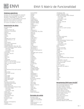
  • 1. ENVI 5 Matriz de Funcionalidad Sistemas operativos • ALOS PRISM • ER Mapper ERS • ALSAT-1 • ERDAS IMAGINE (.img) Windows XP SP2 (Intel/AMD 32- & 64-bit) • ASTER • ESRI Geodatabase Raster Dataset: Windows Vista (Intel/AMD 32- & 64-bit) • ATSR   • Personal (.mdb) Windows 7 (Intel/AMD 32- & 64-bit) • AVHRR   • File (.gdb) Linux Kernel 2.6.x (Intel/AMD 32- & 64-bit) • CARTOSAT-1   • Enterprise (.sde) Mac OS X 10.5.x (Intel 32- & 64-bit) • DMSP (NOAA) • ESRI GRID Max OS X 10.6 (Intel 32- & 64-bit) • ENVISAT AATSR • GeoJP2 / GeoJ2K Sun Solaris 10 (SPARC 32- & 64-bit) • ENVISAT MERIS • GeoTIFF • EROS • HDF4 Importación de datos • FORMOSAT-2 • JPEG • GeoEye-1 • JPEG2000 Fórmatos raster: • IKONOS • NITF 2.0, 2.1 (with license) • ADRG • IRS • PICT • ArcView Raster BIL • KOMPSAT-2 • PCI PIX • ASCII (x,y,z & gridded) • Landsat MSS, TM, ETM+ • PNG • BigTIFF • MAS-50 • SRF • Binary (flat) • MASTER • TIFF • BMP • MISR • XWD • CADRG • MODIS Formatos vectoriales: • CIB • NigeriaSat-1 • AutoCAD DXF • DPPDB (with license) • OrbView-3 • ENVI EVF • DTED (levels 0, 1, 2) • RapidEye • ESRI Geodatabase Feature Class: • ECW • SeaWiFS   • Personal (.mdb) • ENVI Raster • QuickBird   • File (.gdb) • ENVI Gzip Compressed • SPOT   • Enterprise (.sde) • ER Mapper ERS • TIMS • ESRI Shapefile • ERDAS IMAGINE (.img, .ige, .lan) • UK-DMCSat-1 Otros: • ESRI Geodatabase Raster Dataset: • WorldView-1 • Direct To Printer   • Personal (.mdb) • WorldView-2 • Google Earth KML   • File (.gdb) Sensores hiperespectro: • MPEG   • Enterprise (.sde) • AISA • PostScript • ESRI GRID • ARTEMIS (with license) • VRML • GeoJP2 / GeoJ2K • AVIRIS Chip Display To: • GeoTIFF • CASI • ArcMap • HDF4 • HyMap • ENVI Raster • HDF-EOS • Hyperion • ESRI Geodatabase Raster Dataset • JPEG • HyperScan • JPEG • JPEG2000 • HySpex • JPEG2000 / GeoJP2 • MrSID (including MG3) • MIVIS • NITF 2.0, 2.1 (with license) • NITF 1.1, 2.0, 2.1 (with license) • PROBE-1 • PowerPoint PPT • NSIF 1.0 (with license) • ProspecTIR • Printer • PCI PIX Radar: • TIFF / GeoTIFF • PDS • AIRSAR Exportación de mapas a: • PICT • ALOS PALSAR • AI • PNG • COSMO-SkyMed • BMP • RemoteView R-Set (with license) • ENVISAT ASAR • EMF • SRF • ERS • EPS • SRTM DEM • JERS • GIF • TFRD (with license) • RADARSAT-1 • JPEG • TIFF • RADARSAT-2 • PDF • USGS DOQ • SIR-C / X-SAR • PNG • USGS DRG • TOPSAR • Printer • USGS Native DEM Conexiones remotas: • SVG • USGS SDTS DEM • IAS Server • TIFF • XWD • JPIP Formatos vectoriales: • OGC WCS • ARC/INFO Interchange Heramientas ENVI para ArcGIS® • OGC WMS • AutoCAD DXF Spectral Libraries: Auto-Threshold Difference Raster • ENVI Vector File • ASCII Calculate Image Difference • ESRI Geodatabase Feature Class: • ENVI SLI Calculate Thematic Change   • Personal (.mdb) • ASD Indico Classification Raster To Vector   • File (.gdb) • MRSL Classify With Training   • Enterprise (.sde) Anotaciones: Classify Without Training • ESRI Layer • ENVI Annotation Cleanup Classification Raster • ESRI Shapefile Convert Raster Format • MapInfo MIF Detect Anomalies • Microstation DGN Formatos de salida Filter With Convolution • USGS DLG Formatos raster: Intersect Rasters Formatos LiDAR: • ArcView Raster BIL LiDAR To Raster • ASCII • ASCII (x,y,z & gridded) Threshold By Percentage • LAS • BMP Workflow Models with Cleanup Sensores multiespectro: • DTED (levels 0, 1, 2) • ADS40 • ENVI Raster • ALOS AVNIR-2 • ENVI Gzip Compressed pg. 1
  • 2. Funcionalidades de Visualización • Merge ROIs Import Ground Control Points from File • Import ROIs from Vectors Orthorectification: Chip To: Output ROIs to ASCII • Aerial Photographs (Digital and Frame) • File ROI Save & Restore • ASTER • PowerPoint Reconcile ROIs between Images via • CARTOSAT-1 • Print Map Coordinates • Generic RPC • ArcMap ROI Growing Based on Statistics • Generic Pushbroom Sensors Drag/Drop from: • IKONOS ROI Statistics • ArcGIS • OrbView-3 • File System GeoEye-1 • Windows Explorer Preparación de datos WorldView & WorldView-2 • Data Manager Create New Standard or Virtual Image File FORMOSAT-2 Drag/Drop to the: from Existing Bands Kompsat-2 • Display Generate Test Image QuickBird • Process Mask Generation From: SPOT 1-5 • Workflows • Annotation Radial Resampling GeoLink with ArcMap • Image Data Values Rational Polynomial Coefficients Color Mapping • ROIs (RPCs) Support Color Tables: • Intersection of ROIs Replacement Sensor Model (RSM) • Pre-built Tables • Vectors Real-time GPS Link • Interactive Color Table Editor • NaN Rotated Projections Cursor Query for Data/Screen Value, Elevation, Mosaic Functions: Save Transformation Matrix to ASCII Map Coordinates • Color Mosaic Preview Warp Resampling Methods: Dynamic Overlays (unlimited displays) • Cutline & Edge Feathering • Bilinear Histogram Matching Between Displays • Interactively Mosaic Multiple Bands, Files • Cubic Convolution Image Flickering and "Movies" • Mosaic by Pixel (Line, Sample) or Map • Nearest Neighbor Image Overlays: Coordinates Warping Methods: • Annotation • Automatic Color Balancing • Delaunay Triangulation • Classification Results • Standard Image or Virtual Mosaic Output • Polynomial • Contour Lines Define Spatial Subset by: • Rotation, Scaling, Translation (RST) • Density (gray level) Color Slicing • Drawing on Display • Grid Lines • File, Map Coordinates • Regions of Interest • Region of Interest Proyección de mapas • Vector Layers • Other Image Extent Datum Support (90) Interactive 2-D Scatter Plotting • Meta Scroll Extent Dozens of Prebuilt Map Projections (Examples Interactive Histograms & Stretching: NITF Metadata Browser Include): • Arbitrary Stretching Rotate/Flip Data • Universal Transverse Mercator (UTM) • Auto Apply Stretches Spatial and Spectral Subsets • State Plane • Gaussian Stretching Storage Order (Interleave) Conversions: • Albers Conical Equal Area • Histogram Equalization Stretching • BSQ, BIL, BIP • Lambert Conformal Conic • Histogram Matching Between Displays • New File or Replace Original • Miller Cylindrical • Linear, Piecewise Linear Stretching Stretch Data Ellipsoid Support (35) • Square Root Stretching Subsample Images Pseudo-Projections from RPCs and RSM • Import/Export ASCII Look Up Tables • User-Defined Look Up Tables Interactive Pixel Editor Preprocesado y calibrado Vector GIS Functions Line-of-Sight (Viewshed) Analysis Apply Gain & Offset Drag/Drop ArcGIS Layers Link Unlimited Displays Bad Band Identification ArcGIS Layer Attribute Viewing Measurement Tool Bad Line Replacement Add Nodes to Vectors Output Displays PowerPoint: Bad Pixel Replacement Annotate Vector Windows • Create New Presentation Cross-Track Illumination Correction Attributes: • Append to Existing Presentation Dark Subtraction • Create New Vector Attributes Output Displays to File or Printer Destripe Data • Edit Query Vector Attributes Output Displays of Zoom Window Empirical Line Calibration • Import from ArcView Shapefiles, ASCII Quick Filters: ERS and Radarsat Data Calibration • Query to Create New Vector Layer • Sharpen Flat Field Calibration Burn-in Vectors on Raster Image • Smooth Ignore Pixel Value Convert Vector Layer Projection • Median Internal Average Relative Reflectance Create Contour Vectors from Raster Data Quick Color-Infrared, True-Color Displays Calibration Create New Vector Layers Save and/or Restore Display Group Log Residuals Create Vector Boundaries: Select Display Bands from Spectral Plots MODIS Bowtie Correction • Countries, States, Coasts, Rivers Set Default Display Bands Radiometric Calibrations: • For Whole World Spatial and Spectral Pixel Editing • AVHRR • For Lat/Long Boundaries Spatial and Spectral Profiles • Landsat MSS, TM, ETM Direct Printing of GIS Layers Sub-Pixel Cursor Location • TIMS Display Vectors with Different Projections in Unlimited Number of Displays • QuickBird the Same Window Virtual Mosaic Sea Surface Temperature From AVHRR Drag/Drop to Arrange Layer Order Vector Overlays & GIS Capabilities Thermal Atmospheric Correction Edit Layer Characteristics Export Vector Data to Common GIS Formats Export Vector Attributes Áreas de interés Registro y rectificación GPS Input Buffer Zones Around ROIs Associate DEM With Image Heads-up (On-screen) Digitizing Classification Images from ROIs Automatic Georeferencing of ASTER, AVHRR, Intelligent Digitizer Export ROIs to Vectors AATSR, ASAR, MERIS, MODIS, Radarsat, Import Common GIS Formats: Input ROIs from ASCII SeaWiFS, SPOT • ESRI Shapefiles Interactive, Easy-to-use ROI Definition: Subpixel Ground Control Point Locations • Arc Interchange • Draw Polygons, Polylines, Pixels Georectify SPOT Using Information From • AutoCAD DXF • Draw ROIs with Interior Spaces (Donuts) Leader File • MapInfo • ROIs from Intersection of Other ROIs Ground Control Points Prediction • Microstation DGN • Multiple Objects Within One ROI Image-to-Map Registration • USGS DLG • ROI Definition via Scatter Plots Image-to-Image Registration • USGS SDTS • Threshold Images to ROI Interactive Ground Control Point Collection • ENVI Native Vector Format pg. 2
  • 3. Import from ArcGIS GeoDatabase Spectral Slices Matemáticas y estadística Interactive Vector Layer Querying Target - Constrained Interference - Minimized Join Vectors Filter (TCIMF) Autocorrelation Multiple Vector Selection Target Detection Wizard Band Histograms On-the-fly Vector Projection Conversion Vegetation Guided Workflows: Band Math and Spectral Math: Raster to Vector Conversions • Fire Fuel Load • Boolean Operators Save Vectors to ArcGIS GeoDatabase • Agricultural Stress • Trigonometric Functions Split Vectors • Forest Health • Data Type Conversion Functions Vector Cursor Query Vegetation Indices: • Relational Operators Vector Display Zooming • Greenness • Many Other Mathematical Expressions Vector Editing • Light-use Efficiency Correlograms Vector to Raster Conversion • Canopy Nitrogen Display Statistics: • Senescent Carbon • Minimum, Maximum, Mean, Standard • Canopy Water Deviation Herramientas de análisis espectral • Leaf Pigment Image Statistics: • Band Minimum, Maximum, Mean, Standard Adaptive Coherence Estimator (ACE) Vegetation Suppression Algorithm Deviation, Eigenvalues, Eigenvectors, Anomaly Detection Covariance, Correlation Matrices Automated Corner Clustering in N-D Scatter Plot Herramientas SPEAR Output Matrix Stats to Image Files: • Covariance Matrix BandMax Band Optimization Anomaly Detection • Correlation Matrix Constrained Energy Mimimization (CEM) Change Detection - 2 Color Multi-view (2CMV) • Eigenvectors Continuum Removal of Images, Spectra Change Detection - PCA Decision Tree Classifier Change Detection - Subtractive Semivariograms Extraction of Endmember Spectra Google Earth Bridge Integrated Spectral Viewing & Analysis Image-to-Map Registration Linear Spectral Unmixing Clasificación de Imágenes Independent Component Analysis Adaptive Coherence Estimator (ACE) Least Squares (LS) Fit LOC - Lines of Communication - Roads Accuracy Assessment Matched Filtering LOC - Lines of Communication - Water AIRSAR Scattering Mechanism Classifier Mixture Tuned Matched Filtering Metadata Browser Automatic Legends for Classified Images Mixture Tuned Target - Constrained Orthorectification Change Detection - PCA Interference - Minimized Filter (MTTCIMF) Pan Sharpening Change Detection - 2CMV (2 Color N-Dimensional Visualizer (Scatter Plot) Relative Water Depth Multi-view) Orthogonal Subspace Projection (OSP) Spectral Analogues Change Detection - Subtractive Pixel Editing Terrain Categorization (TERCAT) Change Detection, Thematic and Grayscale Pixel Purity Index (PPI) Vegetation Delineation Images SAM Target Finder With BandMax Vertical Stripe Removal Classification Preview SMACC Endmember Extraction & Sub-pixel Watercraft Finder Class Statistics Analysis Classification Image from ROIs SPEAR Tools: Transformaciones Constrained Energy Mimimization (CEM) • Change Detection - Two Color Multi-view Decision Trees (2CMV) Adaptive Coherence Estimator (ACE) Density Slicing • Change Detection - PCA Band Ratios Interactive User-Defined Rule Classifier • Change Detection - Subtractive Color Transforms: Independent Components Analysis • Pan-Sharpening • RGB to HSV, HSL, or Munsell HSV Orthogonal Subspace Projection (OSP) • Lines of Communication - Water • HSV, HSL, or Munsell HSV to RGB Mixture Tuned Target-Constrained Interference • Lines of Communication - Roads Decorrelation Stretch - Minimized Filter (MTTCIMF) • Watercraft Finder Independent Components Analysis Receiver Operating Characteristic (ROC) • Relative Water Depth Image Sharpening: Curves: • Vegetation Delineation and Stress Detection • Color Normalized Spectral • Find Optimal Classification Thresholds • Spectral Analogues • Gram-Schmidt Spectral • Decrease False Classifications • TERCAT (Terrain Categorization) • HSV and Brovey Separate Classification Thresholds for Each Spectral Resampling: • PC Spectral Class • Predefined Sensor Band Filters • Preserving Spectral Integrity Supervised Classifications: • User Defined Filters Minimum Noise Fraction (MNF) • Binary Encoding • Spectral Libraries and Images Normalized Difference Vegetation Index (NDVI) • Parallelepiped Spectral Analyst for Material Identification Pan Sharpening (see Image Sharpening) • Mahalanobis Distance Spectral Angle Mapper (SAM) Principal Components Rotation • Minimum Distance Spectral Feature Fitting (SFF) Saturation Stretch • Maximum Likelihood Spectral Hourglass Wizard Synthetic Color Image • Neural Network Spectral Information Divergence (SID) Tasseled Cap • Spectral Angle Mapper (SAM) Spectral Libraries Included: • Spectral Information Divergence (SID) • Minerals, Vegetation, Rocks, Water, Soils, Filtros • Support Vector Machine (SVM) Snow, • TERCAT (Terrain Categorization) Manmade De adaptación: Target-Constrained Interference-Minimized • VNIR, SWIR, MWIR, LWIR • Frost, Enhanced Frost Gamma, Kuan, Lee, Filter (TCIMF) Spectral Library Builder/Importer Enhanced Lee, Local Sigma, Bit Error Training Data From: Spectral Library Viewer Filtros convolution: • Regions of Interest Spectral Math • High & Low Pass, Laplacian, Directional, • Pixel Spectra Spectral Plots: Gaussian, Median, Sobel, Roberts • Library Spectra • Boxcar Average of Pixel Spectra Filtering Preview Unsupervised Classifications: • Continuum Removal Interactive Fourier Filtering: • K-Means • Cursor Query of X,Y Plot Values • Forward Transform • ISODATA • Drag and Drop Spectra Among Plot • Interactive Frequency Domain Masking Vegetation Guided Workflows: • From 3D SurfaceView • Inverse Transform • Fire Fuel Load • From Image Pixels (Z Profile) De morfología: • Agricultural Stress • From Spectral Libraries • Dilate, Erode, Opening, Closing • Forest Health • From ROI Averages De textura: • Link Spectral Plots from Multiple Images • Data Range, Mean, Variance, Entropy, • Plot Stacked Spectra Skewness, Homogeneity, Contrast, Dissimilarity, • User-Defined Plot Functions Second Moment, Correlation • Wavenumber or Wavelength User-Defined Filter Kernels Subspace Background Suppression (continued on back) pg. 3
  • 4. Herramientas de clasificación Funcionalidad radar Documentación Accuracy Assessment: Adaptive (Speckle Reduction) Filters: Context-Sensitive Help • Kappa Coefficient • Frost Module Documentation • Confusion Matrix • Enhanced Frost On-line, Hyperlinked Documentation Classification to Vector • Gamma Printed Documentation Class Statistics • Kuan Programmer's Guide (with Examples) Interactive Class Overlay Tool • Lee Training Manuals Reassign Class Colors, Names • Enhanced Lee Tutorials & Sample Data Spatial Functions: • Local Sigma User's Guide • Buffer Zones Around Classes • Bit Error • Clump, Sieve, Combine Antenna Pattern Correction * Only available in ENVI+IDL. • Majority & Minority Analysis AIRSAR Scattering Mechanism Classifier • Segmentation Image CEOS Tape Reading ENVI and IDL are registered trademarks Stratified Random Point Generation Convert integrated TOPSAR to: of Exelis Inc. All other trademarks or • C-band VV data brand names are the property of their • Correlation image respective owners. All Rights Reserved. Análisis topográfico • Digital Elevation Model (DEM) Associate DEM with Image • Incident Angle image Calculate Slope and Aspect Images • L- and P-band polarimetric AIRSAR Data Calculate Shaded Relief Image Display and Analyze Radar Data Using Create DEM From Vector Elevation Contours Standard ENVI tools Hillshade (Shaded Relief Combined with RGB Edge Enhancement Filters Image) Import ASAR, ERS, JERS, RADARSAT, AIRSAR, Line-of-Sight (Viewshed) Analysis TOPSAR, SIR-C/X-SAR, ALOS Rasterize Point Data Incident Angle Images Topographic Measures: Multi-Look SIR-C Data • Convexity Pedestal Height Images • Plan Convexity Phase Difference Images • Longitudinal Convexity Polarization Signatures from ROIs & • Cross Sectional convexity Single Pixels • Minimum Curvature RADARSAT-2 Endorsement • Maximum Curvature Sigma nought and Beta nought from ERS, Three-Dimensional Visualization Radarsat Topographic Feature Extraction (Classification): Slant-to-Ground Range Conversion • Ridge, Channel, Plane, Peak, Pit Synthetic Color Image Synthesize Images from Compressed, Complex Scattering Matrix Data 3-D SurfaceView Texture Measures Animated 360º Visualization View CEOS Headers Associate DEM With Image Change View Interactively Using Mouse Create Fly-Through Sequence: Interfaz general y operaciones • Interpolate Between User Selected Views 8- and 24-Bit Color, Multiple Displays • Follow Annotation Line Access to IDL Functions* Custom Background Color Add Custom Routines to Menu Drape Image Over 3-D Surface Batch Recording, Queuing, and Playback Output Fly-Through Sequence: Build Scripts for Common Functions* • MPEG, VRML 2.0 Command Line Use of ENVI Routines * Overlay Vectors, Regions Of Interest Context-Sensitive Mouse Descriptions Set Vertical Exaggeration Cursor Coordinates (Pixel & Map) , Data Values, Smooth Image, DEM and Elevations Direct Link to GPS Devices (Real-time Input) Edit ENVI Header Information Anotación y composición de mapas Efficient Memory Management Map/Print Layout utilizing ArcGIS Templates Extensive Preferences Settings Utilize ArcGIS Layout Templates Geo-Browser Image Selection from Graphical Automatic Contour Labeling Index Map Automatic Legends for Classified Images, Scale Logical Menu-Based GUI (Graphical User Bars, and Color Ramps Text, Polygons, Interface) Polylines, Points, Symbols Multi-Processor Aware Algorithms Burn-in or Overlay Annotations Platform-Independent Operation Recursive Directory Scanning for Files Calle Emilio Muñoz, 35-37, 28037 Cartographic Symbols 902 11 05 04 Contour Lines from DEM, Other Images Support for Files Greater than 2GB informacion@esri.es www.esri.es Counting Tool User-Configurable Menus & Buttons Create Reusable Map Templates Grid Lines: Pixel, Lat/Long &/or Map Grids Inset Images (e.g., Logos) or Vector Plots Módulos Interactive Map Composition Using Image ENVI Atmospheric Correction Module Displays ENVI Certified NITF Module: Interactively Reposition Annotation and Map • ENVI Certified NITF Module with TFRD Elements ENVI DEM Extraction Module for Stereo Images Interactive Plot Scaling ENVI Feature Extraction Module Rotated Map Projections ENVI Orthorectification Module Save & Restore All Parameters SARscape Family of Modules for ENVI TrueType® Fonts (Plus Add Your Own) User Definable Arrows, Declination Diagrams (True, Grid and Magnetic North) Exelis Visual Information Solutions Vector Overlays 4990 Pearl East Circle • Boulder CO, 80301 303.786.9900 • www.exelisvis.com pg. 4