SlideShare ist ein Scribd-Unternehmen logo
1 von 1
Downloaden Sie, um offline zu lesen
Climate Impacts Water Resources
Meet the Challenge with GIS
Modeling how weather will impact water resource systems
helps managers be ready for the future rather than succumb
to it. Geographic information system (GIS) software helps you
understand water problems and plan for sustainable response.
Water resource planners use the analytic power of ArcGISÂź to
‱	 Study weather patterns.
‱	 Perform hydrographic modeling.
‱	 Create what-if scenarios.
‱	 Prioritize resource policy.
‱	 Build plans on scientific data and analyses.
‱	 Turn the unforeseen into the foreseen.
EsriÂź GIS for Water Management
ArcGIS technology gives you tools to evaluate, analyze,
predict, and collaborate.

Visualization of potential sea level rise inundation.

ArcGIS Online gives you access to geographic content from
Esri and GIS users.
SM

ArcGIS Resource Center gets you started with Arc Hydro data
models, tools, scripts, and news.
What can GIS do for you? Find the answers at 		

esri.com/waterresources.

Copyright © 2013 Esri. All rights reserved. Esri, the Esri globe logo, ArcGIS, and esri.com are trademarks, registered trademarks, or service marks of Esri in the
United States, the European Community, or certain other jurisdictions. Other companies and products mentioned herein may be trademarks or registered
trademarks of their respective trademark owners.

139384 Esri7.6C11/13ml

Weitere Àhnliche Inhalte

Ähnlich wie Climate Impacts Water Resources

Esri News for Oceans Fall 2012 newsletter
Esri News for Oceans Fall 2012 newsletterEsri News for Oceans Fall 2012 newsletter
Esri News for Oceans Fall 2012 newsletterEsri
 
GeoPlanner for ArcGIS
GeoPlanner for ArcGISGeoPlanner for ArcGIS
GeoPlanner for ArcGISEsri
 
Esri GIS Improves Adaptive Integrated Water Resource Management
Esri GIS Improves Adaptive Integrated Water Resource ManagementEsri GIS Improves Adaptive Integrated Water Resource Management
Esri GIS Improves Adaptive Integrated Water Resource ManagementEsri
 
GIS for Maritime Users
GIS for Maritime UsersGIS for Maritime Users
GIS for Maritime UsersEsri
 
Spring 2013
Spring 2013Spring 2013
Spring 2013Esri
 
ArcGIS
ArcGISArcGIS
ArcGISEsri
 
Implementing ArcGIS for Water Utilities
Implementing ArcGIS for Water UtilitiesImplementing ArcGIS for Water Utilities
Implementing ArcGIS for Water UtilitiesEsri
 
Forest Management with Esri
Forest Management with EsriForest Management with Esri
Forest Management with EsriEsri
 
ArcGIS for Desktop
ArcGIS for DesktopArcGIS for Desktop
ArcGIS for DesktopEsri
 
ArcGIS
ArcGISArcGIS
ArcGISEsri
 
Esri News for Petroleum Winter 2012/2013 newsletter
Esri News for Petroleum Winter 2012/2013 newsletterEsri News for Petroleum Winter 2012/2013 newsletter
Esri News for Petroleum Winter 2012/2013 newsletterEsri
 
Esri News for Federal Government Winter 2012/2013 issue
Esri News for Federal Government Winter 2012/2013 issueEsri News for Federal Government Winter 2012/2013 issue
Esri News for Federal Government Winter 2012/2013 issueEsri
 
ArcGIS for Local Government
ArcGIS for Local GovernmentArcGIS for Local Government
ArcGIS for Local GovernmentEsri
 
GIS for Facilities Overview
GIS for Facilities OverviewGIS for Facilities Overview
GIS for Facilities OverviewEsri
 
Esri News for Petroleum Winter 2013/2014 newsletter
Esri News for Petroleum Winter 2013/2014 newsletterEsri News for Petroleum Winter 2013/2014 newsletter
Esri News for Petroleum Winter 2013/2014 newsletterEsri
 
ArcGIS for the Military--Maritime Operations
ArcGIS for the Military--Maritime OperationsArcGIS for the Military--Maritime Operations
ArcGIS for the Military--Maritime OperationsEsri
 
How ArcGIS for the Military Supports Maritime Operations
How ArcGIS for the Military Supports Maritime OperationsHow ArcGIS for the Military Supports Maritime Operations
How ArcGIS for the Military Supports Maritime OperationsEsri
 
Role of gis in climate change
Role of gis in climate changeRole of gis in climate change
Role of gis in climate changeSalar Saeed Dogar
 
FlightlineGeo_ESRI_Newsletter_winter2014
FlightlineGeo_ESRI_Newsletter_winter2014FlightlineGeo_ESRI_Newsletter_winter2014
FlightlineGeo_ESRI_Newsletter_winter2014Devon Humphrey
 

Ähnlich wie Climate Impacts Water Resources (20)

Esri News for Oceans Fall 2012 newsletter
Esri News for Oceans Fall 2012 newsletterEsri News for Oceans Fall 2012 newsletter
Esri News for Oceans Fall 2012 newsletter
 
GeoPlanner for ArcGIS
GeoPlanner for ArcGISGeoPlanner for ArcGIS
GeoPlanner for ArcGIS
 
Esri GIS Improves Adaptive Integrated Water Resource Management
Esri GIS Improves Adaptive Integrated Water Resource ManagementEsri GIS Improves Adaptive Integrated Water Resource Management
Esri GIS Improves Adaptive Integrated Water Resource Management
 
GIS for Maritime Users
GIS for Maritime UsersGIS for Maritime Users
GIS for Maritime Users
 
Spring 2013
Spring 2013Spring 2013
Spring 2013
 
ArcGIS
ArcGISArcGIS
ArcGIS
 
Implementing ArcGIS for Water Utilities
Implementing ArcGIS for Water UtilitiesImplementing ArcGIS for Water Utilities
Implementing ArcGIS for Water Utilities
 
Forest Management with Esri
Forest Management with EsriForest Management with Esri
Forest Management with Esri
 
ArcGIS for Desktop
ArcGIS for DesktopArcGIS for Desktop
ArcGIS for Desktop
 
ArcGIS
ArcGISArcGIS
ArcGIS
 
Esri News for Petroleum Winter 2012/2013 newsletter
Esri News for Petroleum Winter 2012/2013 newsletterEsri News for Petroleum Winter 2012/2013 newsletter
Esri News for Petroleum Winter 2012/2013 newsletter
 
Esri News for Federal Government Winter 2012/2013 issue
Esri News for Federal Government Winter 2012/2013 issueEsri News for Federal Government Winter 2012/2013 issue
Esri News for Federal Government Winter 2012/2013 issue
 
ArcGIS for Local Government
ArcGIS for Local GovernmentArcGIS for Local Government
ArcGIS for Local Government
 
GIS for Facilities Overview
GIS for Facilities OverviewGIS for Facilities Overview
GIS for Facilities Overview
 
Esri News for Petroleum Winter 2013/2014 newsletter
Esri News for Petroleum Winter 2013/2014 newsletterEsri News for Petroleum Winter 2013/2014 newsletter
Esri News for Petroleum Winter 2013/2014 newsletter
 
ArcGIS for the Military--Maritime Operations
ArcGIS for the Military--Maritime OperationsArcGIS for the Military--Maritime Operations
ArcGIS for the Military--Maritime Operations
 
How ArcGIS for the Military Supports Maritime Operations
How ArcGIS for the Military Supports Maritime OperationsHow ArcGIS for the Military Supports Maritime Operations
How ArcGIS for the Military Supports Maritime Operations
 
Extension arc gis
Extension arc gisExtension arc gis
Extension arc gis
 
Role of gis in climate change
Role of gis in climate changeRole of gis in climate change
Role of gis in climate change
 
FlightlineGeo_ESRI_Newsletter_winter2014
FlightlineGeo_ESRI_Newsletter_winter2014FlightlineGeo_ESRI_Newsletter_winter2014
FlightlineGeo_ESRI_Newsletter_winter2014
 

Mehr von Esri

INIA- CISA: AnĂĄlisis de las amenazas en la fauna silvestre
INIA- CISA: AnĂĄlisis de las amenazas en la fauna silvestreINIA- CISA: AnĂĄlisis de las amenazas en la fauna silvestre
INIA- CISA: AnĂĄlisis de las amenazas en la fauna silvestreEsri
 
Aena Aeropuerto Adolfo SuĂĄrez-Barajas crea potentes aplicaciones para sus cli...
Aena Aeropuerto Adolfo SuĂĄrez-Barajas crea potentes aplicaciones para sus cli...Aena Aeropuerto Adolfo SuĂĄrez-Barajas crea potentes aplicaciones para sus cli...
Aena Aeropuerto Adolfo SuĂĄrez-Barajas crea potentes aplicaciones para sus cli...Esri
 
Plataforma Smart City de MĂłstoles
Plataforma Smart City de MĂłstolesPlataforma Smart City de MĂłstoles
Plataforma Smart City de MĂłstolesEsri
 
ArcGIS Online para Organizaciones
ArcGIS Online para OrganizacionesArcGIS Online para Organizaciones
ArcGIS Online para OrganizacionesEsri
 
Molina de Segura se convierte en una smart city
Molina de Segura se convierte en una smart cityMolina de Segura se convierte en una smart city
Molina de Segura se convierte en una smart cityEsri
 
Portal for ArcGIS
Portal for ArcGISPortal for ArcGIS
Portal for ArcGISEsri
 
GIS-Based Web Services Provide Rapid Analysis and Dissemination of Maritime Data
GIS-Based Web Services Provide Rapid Analysis and Dissemination of Maritime DataGIS-Based Web Services Provide Rapid Analysis and Dissemination of Maritime Data
GIS-Based Web Services Provide Rapid Analysis and Dissemination of Maritime DataEsri
 
An Effective Tool for Drinking Water Protection
An Effective Tool for Drinking Water ProtectionAn Effective Tool for Drinking Water Protection
An Effective Tool for Drinking Water ProtectionEsri
 
GeoCollector for ArcPad
GeoCollector for ArcPadGeoCollector for ArcPad
GeoCollector for ArcPadEsri
 
GeoCollector for ArcGIS for Windows Mobile
GeoCollector for ArcGIS for Windows MobileGeoCollector for ArcGIS for Windows Mobile
GeoCollector for ArcGIS for Windows MobileEsri
 
Data Appliance for ArcGIS
Data Appliance for ArcGISData Appliance for ArcGIS
Data Appliance for ArcGISEsri
 
Esri and BlackBridge
Esri and BlackBridgeEsri and BlackBridge
Esri and BlackBridgeEsri
 
Esri and AccuWeather
Esri and AccuWeatherEsri and AccuWeather
Esri and AccuWeatherEsri
 
Esri and Airbus Defense & Space
Esri and Airbus Defense & SpaceEsri and Airbus Defense & Space
Esri and Airbus Defense & SpaceEsri
 
Esri US Data Fact Sheet
Esri US Data Fact SheetEsri US Data Fact Sheet
Esri US Data Fact SheetEsri
 
ArcGIS for Server on Microsoft Azure Jumpstart
ArcGIS for Server on Microsoft Azure JumpstartArcGIS for Server on Microsoft Azure Jumpstart
ArcGIS for Server on Microsoft Azure JumpstartEsri
 
Esri Geoportal Server
Esri Geoportal ServerEsri Geoportal Server
Esri Geoportal ServerEsri
 
ArcGIS GeoEvent Extension for Server
ArcGIS GeoEvent Extension for ServerArcGIS GeoEvent Extension for Server
ArcGIS GeoEvent Extension for ServerEsri
 
The NATO Core Geographic Services System
The NATO Core Geographic Services SystemThe NATO Core Geographic Services System
The NATO Core Geographic Services SystemEsri
 
ArcGIS for Desktop Tips and Shortcuts
ArcGIS for Desktop Tips and ShortcutsArcGIS for Desktop Tips and Shortcuts
ArcGIS for Desktop Tips and ShortcutsEsri
 

Mehr von Esri (20)

INIA- CISA: AnĂĄlisis de las amenazas en la fauna silvestre
INIA- CISA: AnĂĄlisis de las amenazas en la fauna silvestreINIA- CISA: AnĂĄlisis de las amenazas en la fauna silvestre
INIA- CISA: AnĂĄlisis de las amenazas en la fauna silvestre
 
Aena Aeropuerto Adolfo SuĂĄrez-Barajas crea potentes aplicaciones para sus cli...
Aena Aeropuerto Adolfo SuĂĄrez-Barajas crea potentes aplicaciones para sus cli...Aena Aeropuerto Adolfo SuĂĄrez-Barajas crea potentes aplicaciones para sus cli...
Aena Aeropuerto Adolfo SuĂĄrez-Barajas crea potentes aplicaciones para sus cli...
 
Plataforma Smart City de MĂłstoles
Plataforma Smart City de MĂłstolesPlataforma Smart City de MĂłstoles
Plataforma Smart City de MĂłstoles
 
ArcGIS Online para Organizaciones
ArcGIS Online para OrganizacionesArcGIS Online para Organizaciones
ArcGIS Online para Organizaciones
 
Molina de Segura se convierte en una smart city
Molina de Segura se convierte en una smart cityMolina de Segura se convierte en una smart city
Molina de Segura se convierte en una smart city
 
Portal for ArcGIS
Portal for ArcGISPortal for ArcGIS
Portal for ArcGIS
 
GIS-Based Web Services Provide Rapid Analysis and Dissemination of Maritime Data
GIS-Based Web Services Provide Rapid Analysis and Dissemination of Maritime DataGIS-Based Web Services Provide Rapid Analysis and Dissemination of Maritime Data
GIS-Based Web Services Provide Rapid Analysis and Dissemination of Maritime Data
 
An Effective Tool for Drinking Water Protection
An Effective Tool for Drinking Water ProtectionAn Effective Tool for Drinking Water Protection
An Effective Tool for Drinking Water Protection
 
GeoCollector for ArcPad
GeoCollector for ArcPadGeoCollector for ArcPad
GeoCollector for ArcPad
 
GeoCollector for ArcGIS for Windows Mobile
GeoCollector for ArcGIS for Windows MobileGeoCollector for ArcGIS for Windows Mobile
GeoCollector for ArcGIS for Windows Mobile
 
Data Appliance for ArcGIS
Data Appliance for ArcGISData Appliance for ArcGIS
Data Appliance for ArcGIS
 
Esri and BlackBridge
Esri and BlackBridgeEsri and BlackBridge
Esri and BlackBridge
 
Esri and AccuWeather
Esri and AccuWeatherEsri and AccuWeather
Esri and AccuWeather
 
Esri and Airbus Defense & Space
Esri and Airbus Defense & SpaceEsri and Airbus Defense & Space
Esri and Airbus Defense & Space
 
Esri US Data Fact Sheet
Esri US Data Fact SheetEsri US Data Fact Sheet
Esri US Data Fact Sheet
 
ArcGIS for Server on Microsoft Azure Jumpstart
ArcGIS for Server on Microsoft Azure JumpstartArcGIS for Server on Microsoft Azure Jumpstart
ArcGIS for Server on Microsoft Azure Jumpstart
 
Esri Geoportal Server
Esri Geoportal ServerEsri Geoportal Server
Esri Geoportal Server
 
ArcGIS GeoEvent Extension for Server
ArcGIS GeoEvent Extension for ServerArcGIS GeoEvent Extension for Server
ArcGIS GeoEvent Extension for Server
 
The NATO Core Geographic Services System
The NATO Core Geographic Services SystemThe NATO Core Geographic Services System
The NATO Core Geographic Services System
 
ArcGIS for Desktop Tips and Shortcuts
ArcGIS for Desktop Tips and ShortcutsArcGIS for Desktop Tips and Shortcuts
ArcGIS for Desktop Tips and Shortcuts
 

KĂŒrzlich hochgeladen

Top 10 Most Downloaded Games on Play Store in 2024
Top 10 Most Downloaded Games on Play Store in 2024Top 10 Most Downloaded Games on Play Store in 2024
Top 10 Most Downloaded Games on Play Store in 2024SynarionITSolutions
 
A Domino Admins Adventures (Engage 2024)
A Domino Admins Adventures (Engage 2024)A Domino Admins Adventures (Engage 2024)
A Domino Admins Adventures (Engage 2024)Gabriella Davis
 
The 7 Things I Know About Cyber Security After 25 Years | April 2024
The 7 Things I Know About Cyber Security After 25 Years | April 2024The 7 Things I Know About Cyber Security After 25 Years | April 2024
The 7 Things I Know About Cyber Security After 25 Years | April 2024Rafal Los
 
Artificial Intelligence: Facts and Myths
Artificial Intelligence: Facts and MythsArtificial Intelligence: Facts and Myths
Artificial Intelligence: Facts and MythsJoaquim Jorge
 
Workshop - Best of Both Worlds_ Combine KG and Vector search for enhanced R...
Workshop - Best of Both Worlds_ Combine  KG and Vector search for  enhanced R...Workshop - Best of Both Worlds_ Combine  KG and Vector search for  enhanced R...
Workshop - Best of Both Worlds_ Combine KG and Vector search for enhanced R...Neo4j
 
Cloud Frontiers: A Deep Dive into Serverless Spatial Data and FME
Cloud Frontiers:  A Deep Dive into Serverless Spatial Data and FMECloud Frontiers:  A Deep Dive into Serverless Spatial Data and FME
Cloud Frontiers: A Deep Dive into Serverless Spatial Data and FMESafe Software
 
TrustArc Webinar - Unlock the Power of AI-Driven Data Discovery
TrustArc Webinar - Unlock the Power of AI-Driven Data DiscoveryTrustArc Webinar - Unlock the Power of AI-Driven Data Discovery
TrustArc Webinar - Unlock the Power of AI-Driven Data DiscoveryTrustArc
 
Apidays New York 2024 - The Good, the Bad and the Governed by David O'Neill, ...
Apidays New York 2024 - The Good, the Bad and the Governed by David O'Neill, ...Apidays New York 2024 - The Good, the Bad and the Governed by David O'Neill, ...
Apidays New York 2024 - The Good, the Bad and the Governed by David O'Neill, ...apidays
 
Bajaj Allianz Life Insurance Company - Insurer Innovation Award 2024
Bajaj Allianz Life Insurance Company - Insurer Innovation Award 2024Bajaj Allianz Life Insurance Company - Insurer Innovation Award 2024
Bajaj Allianz Life Insurance Company - Insurer Innovation Award 2024The Digital Insurer
 
Strategies for Landing an Oracle DBA Job as a Fresher
Strategies for Landing an Oracle DBA Job as a FresherStrategies for Landing an Oracle DBA Job as a Fresher
Strategies for Landing an Oracle DBA Job as a FresherRemote DBA Services
 
ProductAnonymous-April2024-WinProductDiscovery-MelissaKlemke
ProductAnonymous-April2024-WinProductDiscovery-MelissaKlemkeProductAnonymous-April2024-WinProductDiscovery-MelissaKlemke
ProductAnonymous-April2024-WinProductDiscovery-MelissaKlemkeProduct Anonymous
 
Scaling API-first – The story of a global engineering organization
Scaling API-first – The story of a global engineering organizationScaling API-first – The story of a global engineering organization
Scaling API-first – The story of a global engineering organizationRadu Cotescu
 
How to Troubleshoot Apps for the Modern Connected Worker
How to Troubleshoot Apps for the Modern Connected WorkerHow to Troubleshoot Apps for the Modern Connected Worker
How to Troubleshoot Apps for the Modern Connected WorkerThousandEyes
 
presentation ICT roal in 21st century education
presentation ICT roal in 21st century educationpresentation ICT roal in 21st century education
presentation ICT roal in 21st century educationjfdjdjcjdnsjd
 
Apidays New York 2024 - Scaling API-first by Ian Reasor and Radu Cotescu, Adobe
Apidays New York 2024 - Scaling API-first by Ian Reasor and Radu Cotescu, AdobeApidays New York 2024 - Scaling API-first by Ian Reasor and Radu Cotescu, Adobe
Apidays New York 2024 - Scaling API-first by Ian Reasor and Radu Cotescu, Adobeapidays
 
Apidays Singapore 2024 - Building Digital Trust in a Digital Economy by Veron...
Apidays Singapore 2024 - Building Digital Trust in a Digital Economy by Veron...Apidays Singapore 2024 - Building Digital Trust in a Digital Economy by Veron...
Apidays Singapore 2024 - Building Digital Trust in a Digital Economy by Veron...apidays
 
Partners Life - Insurer Innovation Award 2024
Partners Life - Insurer Innovation Award 2024Partners Life - Insurer Innovation Award 2024
Partners Life - Insurer Innovation Award 2024The Digital Insurer
 
Mastering MySQL Database Architecture: Deep Dive into MySQL Shell and MySQL R...
Mastering MySQL Database Architecture: Deep Dive into MySQL Shell and MySQL R...Mastering MySQL Database Architecture: Deep Dive into MySQL Shell and MySQL R...
Mastering MySQL Database Architecture: Deep Dive into MySQL Shell and MySQL R...Miguel AraĂșjo
 
A Year of the Servo Reboot: Where Are We Now?
A Year of the Servo Reboot: Where Are We Now?A Year of the Servo Reboot: Where Are We Now?
A Year of the Servo Reboot: Where Are We Now?Igalia
 

KĂŒrzlich hochgeladen (20)

Top 10 Most Downloaded Games on Play Store in 2024
Top 10 Most Downloaded Games on Play Store in 2024Top 10 Most Downloaded Games on Play Store in 2024
Top 10 Most Downloaded Games on Play Store in 2024
 
A Domino Admins Adventures (Engage 2024)
A Domino Admins Adventures (Engage 2024)A Domino Admins Adventures (Engage 2024)
A Domino Admins Adventures (Engage 2024)
 
The 7 Things I Know About Cyber Security After 25 Years | April 2024
The 7 Things I Know About Cyber Security After 25 Years | April 2024The 7 Things I Know About Cyber Security After 25 Years | April 2024
The 7 Things I Know About Cyber Security After 25 Years | April 2024
 
+971581248768>> SAFE AND ORIGINAL ABORTION PILLS FOR SALE IN DUBAI AND ABUDHA...
+971581248768>> SAFE AND ORIGINAL ABORTION PILLS FOR SALE IN DUBAI AND ABUDHA...+971581248768>> SAFE AND ORIGINAL ABORTION PILLS FOR SALE IN DUBAI AND ABUDHA...
+971581248768>> SAFE AND ORIGINAL ABORTION PILLS FOR SALE IN DUBAI AND ABUDHA...
 
Artificial Intelligence: Facts and Myths
Artificial Intelligence: Facts and MythsArtificial Intelligence: Facts and Myths
Artificial Intelligence: Facts and Myths
 
Workshop - Best of Both Worlds_ Combine KG and Vector search for enhanced R...
Workshop - Best of Both Worlds_ Combine  KG and Vector search for  enhanced R...Workshop - Best of Both Worlds_ Combine  KG and Vector search for  enhanced R...
Workshop - Best of Both Worlds_ Combine KG and Vector search for enhanced R...
 
Cloud Frontiers: A Deep Dive into Serverless Spatial Data and FME
Cloud Frontiers:  A Deep Dive into Serverless Spatial Data and FMECloud Frontiers:  A Deep Dive into Serverless Spatial Data and FME
Cloud Frontiers: A Deep Dive into Serverless Spatial Data and FME
 
TrustArc Webinar - Unlock the Power of AI-Driven Data Discovery
TrustArc Webinar - Unlock the Power of AI-Driven Data DiscoveryTrustArc Webinar - Unlock the Power of AI-Driven Data Discovery
TrustArc Webinar - Unlock the Power of AI-Driven Data Discovery
 
Apidays New York 2024 - The Good, the Bad and the Governed by David O'Neill, ...
Apidays New York 2024 - The Good, the Bad and the Governed by David O'Neill, ...Apidays New York 2024 - The Good, the Bad and the Governed by David O'Neill, ...
Apidays New York 2024 - The Good, the Bad and the Governed by David O'Neill, ...
 
Bajaj Allianz Life Insurance Company - Insurer Innovation Award 2024
Bajaj Allianz Life Insurance Company - Insurer Innovation Award 2024Bajaj Allianz Life Insurance Company - Insurer Innovation Award 2024
Bajaj Allianz Life Insurance Company - Insurer Innovation Award 2024
 
Strategies for Landing an Oracle DBA Job as a Fresher
Strategies for Landing an Oracle DBA Job as a FresherStrategies for Landing an Oracle DBA Job as a Fresher
Strategies for Landing an Oracle DBA Job as a Fresher
 
ProductAnonymous-April2024-WinProductDiscovery-MelissaKlemke
ProductAnonymous-April2024-WinProductDiscovery-MelissaKlemkeProductAnonymous-April2024-WinProductDiscovery-MelissaKlemke
ProductAnonymous-April2024-WinProductDiscovery-MelissaKlemke
 
Scaling API-first – The story of a global engineering organization
Scaling API-first – The story of a global engineering organizationScaling API-first – The story of a global engineering organization
Scaling API-first – The story of a global engineering organization
 
How to Troubleshoot Apps for the Modern Connected Worker
How to Troubleshoot Apps for the Modern Connected WorkerHow to Troubleshoot Apps for the Modern Connected Worker
How to Troubleshoot Apps for the Modern Connected Worker
 
presentation ICT roal in 21st century education
presentation ICT roal in 21st century educationpresentation ICT roal in 21st century education
presentation ICT roal in 21st century education
 
Apidays New York 2024 - Scaling API-first by Ian Reasor and Radu Cotescu, Adobe
Apidays New York 2024 - Scaling API-first by Ian Reasor and Radu Cotescu, AdobeApidays New York 2024 - Scaling API-first by Ian Reasor and Radu Cotescu, Adobe
Apidays New York 2024 - Scaling API-first by Ian Reasor and Radu Cotescu, Adobe
 
Apidays Singapore 2024 - Building Digital Trust in a Digital Economy by Veron...
Apidays Singapore 2024 - Building Digital Trust in a Digital Economy by Veron...Apidays Singapore 2024 - Building Digital Trust in a Digital Economy by Veron...
Apidays Singapore 2024 - Building Digital Trust in a Digital Economy by Veron...
 
Partners Life - Insurer Innovation Award 2024
Partners Life - Insurer Innovation Award 2024Partners Life - Insurer Innovation Award 2024
Partners Life - Insurer Innovation Award 2024
 
Mastering MySQL Database Architecture: Deep Dive into MySQL Shell and MySQL R...
Mastering MySQL Database Architecture: Deep Dive into MySQL Shell and MySQL R...Mastering MySQL Database Architecture: Deep Dive into MySQL Shell and MySQL R...
Mastering MySQL Database Architecture: Deep Dive into MySQL Shell and MySQL R...
 
A Year of the Servo Reboot: Where Are We Now?
A Year of the Servo Reboot: Where Are We Now?A Year of the Servo Reboot: Where Are We Now?
A Year of the Servo Reboot: Where Are We Now?
 

Climate Impacts Water Resources

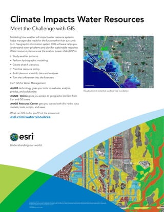
  • 1. Climate Impacts Water Resources Meet the Challenge with GIS Modeling how weather will impact water resource systems helps managers be ready for the future rather than succumb to it. Geographic information system (GIS) software helps you understand water problems and plan for sustainable response. Water resource planners use the analytic power of ArcGISÂź to ‱ Study weather patterns. ‱ Perform hydrographic modeling. ‱ Create what-if scenarios. ‱ Prioritize resource policy. ‱ Build plans on scientific data and analyses. ‱ Turn the unforeseen into the foreseen. EsriÂź GIS for Water Management ArcGIS technology gives you tools to evaluate, analyze, predict, and collaborate. Visualization of potential sea level rise inundation. ArcGIS Online gives you access to geographic content from Esri and GIS users. SM ArcGIS Resource Center gets you started with Arc Hydro data models, tools, scripts, and news. What can GIS do for you? Find the answers at esri.com/waterresources. Copyright © 2013 Esri. All rights reserved. Esri, the Esri globe logo, ArcGIS, and esri.com are trademarks, registered trademarks, or service marks of Esri in the United States, the European Community, or certain other jurisdictions. Other companies and products mentioned herein may be trademarks or registered trademarks of their respective trademark owners. 139384 Esri7.6C11/13ml