Best Of Korea- South Korea-kpop-k-drama-Kculture- kbeauty
US-28 (US-126) - A Scenic Road Trip through the Cascade Range
1. US-28 (US-126) – A Scenic Road Trip through the Cascade Range
By Donald Dale Milne
https://www.roadtrip62.com/us-28-us-126–a-scenic-road-trip-through-the-cascade-range.htm
This week, Roadtrip-'62 ™ travels along US-28, a number that was already gone by 1962! When it did exist, it was only 462 miles long and located
completely in Oregon. It followed what is now US-26 about halfway across Oregon, from Ontario to Prineville. We already covered that section from Ontario to
Prineville as US-26 at https://roadtrip62.com/roadtrip-highlights-along-us-26.htm . From Prineville to Eugene, it was already renumbered US-126 by 1962.
Even that number was eliminated in 1972 and that portion is now OR-126. But let’s take a look at that final 131 miles as it existed as US-126 in 1962.
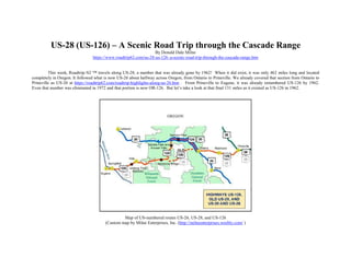
Map of US-numbered routes US-26, US-28, and US-126
(Custom map by Milne Enterprises, Inc. (http://milneenterprises.weebly.com/ )
2. That 131 miles mostly travels across the Cascade Range of mountains and as such is very scenic. Leaving Prineville, we immediately pass Ochoco
Wayside State Park, which includes the Ochoco View Point, giving panoramic views of the area from a rock hill. We’re still in the dry country here, with no
mountains in sight, but we begin climbing soon after. As we get higher, we pass through some farm country around the settlement of Powell Butte. We continue
climbing through ranch pasturelands on the way to Redmond, Oregon. The Redmond area sits on some ancient lava flows from volcanic mountains in the nearby
Cascade Range. <a href=”https://www.blm.gov/visit/redmond-caves-recreation-site” >Redmond Caves Recreation Area</a> is a great introduction to the lava
and the caves it has left behind. There are five caves where you can learn about geology, wildlife and past human use over the last 6,000 years. During the
1960s, the caves were considered for fallout shelters! The three largest caves were reviewed and rated to have a capacity up to 450 people. These caves are part
of the large Horse Lava Tube System and extend south to near the city of Bend. Overall, there are 122 known caves in the system with one having a walkable
length of nearly 4,000 feet.
Cline Falls, Oregon
(Public domain photo by Bonnie Moreland at Flickr. (see https://www.flickr.com/photos/icetsarina/ )
3. Highway US-126 continues westerly through the high desert and range, where you might see a truck hauling hay in front of you. The first foothills of
the mountains loom in the distance, and we’ll get there soon. First, we’ll stop at Cline Falls State Park, which is strangely NOT at the falls. The park is south of
US-126 and was originally bought by the Highway Commission in 1936 for a gravel pit, but the falls are a short distance north of the highway, not even within
the park boundary. However, you can see the Deschutes River as it descends through some small rapids and pools around some very large boulders. The scenery
changes little as we roll into Sisters, Oregon, a city founded on lumbering the pine forests of the nearby hills. Driving through in 1962 we would have been near
the end of the lumbering, as the last sawmill closed in 1963 and was soon dismantled. At the east edge of town is Sisters State Park, which was established in
1939. It is mostly open conifer forest: a large stand of old-growth Ponderosa pine. It’s a small park split by the highway but adjacent to two city parks and
connected by a covered walking bridge. Sisters is also a great place to stop for ice cream, at the Sno Cap Drive In. Sno Cap was opened in 1952 and makes old
fashioned milkshakes and burgers, with some flavors of ice cream made right on the premises!
At Sisters, we join US-20 and travel together (see https://www.roadtrip62.com/us-20-the-second-longest-road-trip.htm ) to about 10 miles west of
Santiam Pass. The sign at the west edge of town announces that we are now on the McKenzie Pass / Santiam Pass Oregon Scenic Byway, so we know we are
getting close to the mountains. The pine tree landscape we saw as we entered town continues here and we enter the Deschutes National Forest (see
https://www.fs.usda.gov/deschutes/ ). For my tastes, this is where the great scenery begins. Though we begin in a sparse Ponderosa pine forest, the National
Forest spans a variety of landscapes, ecosystems, and elevations. The lowest point is only 1,950 feet above sea level, while the highest, at South Sister’s summit,
is 10,358 feet. We will eventually cross the mountains at Santiam Pass at 4,817 feet and catch views of Mt. Washington at 7,794 feet. Deschutes National Forest
has changed names and size several times over its history, starting in 1908 as parts of the Blue Mountains, Cascade, and Fremont National Forests. Though the
sawmill in Sisters closed, there are plenty of logging trucks on US-126 taking the lumber longer distances to other mills.
Santiam Pass sign, Willamette National Forest, Oregon
(Photo by Kirt Edblom at Flickr (at https://www.flickr.com/photos/kirt_edblom/ ),
licensed under Creative Commons Attribution-ShareAlike 2.0 Generic license. (https://creativecommons.org/licenses/by-sa/2.0/ )
4. Beautiful Suttle Lake is below us and reachable from a short side road. It has a day use beach area. We pass numerous signs pointing to wilderness
hiking in the backcountry. Even nearby Elliot R. Corbett State Park is accessible only by hiking in, so it doesn’t have as many visitors as other state parks in the
area. It sits above the south shore of Blue Lake, which consists of three craters overlapping each other. The park was acquired as a gift to the state of Oregon in
1952 from Henry L. Corbett and his wife Gretchen, on condition that the lands remain a wilderness area. The Mt. Washington Observation Site turnout is
nearby, giving us great views of that and other mountains from near our highest point. Though we now cross the Cascades through Santiam Pass, in 1962 the
route was changed. Early in that year, it used McKenzie Pass, which is now OR-242. The current route was paved that year and US-126 moved. McKenzie
Pass is about 500 feet higher than the current highway, so was a more difficult route. Route OR-242 is not plowed or sanded in the winter and is closed the, so
stick with US-126 from November through the end of June.
You can see plenty of snow-covered mountain tops from here. There are side roads to several ski areas that take advantage of all that snow. Depending
on what time of year you drive here, you may see Lost Lake on the north side of the highway…or not. This shallow lake has two hollow lava tubes beneath it
that drain the water just like a bathtub. In the rainy fall through spring months, the lake has water. But during the drier summer and fall, these tubes are large
enough to drain the lake dry, leaving a meadow behind. The lake is only about 9 feet deep when full and has no natural streams to drain it. The eventual outlet
of the tubes is not known. As we saw back at Redmond, Oregon has many lava tubes from old volcanic activity. When lava streams flow, the outside crust cools
as it makes contact with air but the hot lava continues to flow under the hardened crust. These can later collapse, leaving us tubes, caves, and holes in the bottom
of lakes.
Watch a drone view of Lost Lake draining down one of its lava tubes in this video by Ryan Brennecke at YouTube:
https://www.youtube.com/watch?v=kpRRkXnRc0E .
Across the pass, US-20 leaves us and heads northwest to Newport, Oregon. We also cross into Willamette National Forest (see
https://www.fs.usda.gov/main/willamette/home ) but we are not out of the Cascade Mountains yet, as there are plenty of peaks visible ahead. Piles of lava
boulders are added to the forest landscape as we travel a bit southwest and pass Sahalie Falls and Koosah Falls, on the McKenzie River. A loop trail through an
old growth conifer forest takes you to the falls and a bridge across the river. Close up views of the wild McKenzie River are all around as it passes over cascades
between the 100-foot high Sahalie Falls and its shorter neighbor. There are interpretive panels that tell the story of area geology along the way. After the falls,
the riverbed is dry for three miles because a lava flow buried the river about 1,600 years ago! The river flows under it now and resurfaces at Tamolitch Pool. A
short ways down the road is Belknap Hot Springs, a private resort. There are two mineral hot spring pools at the resort, which has been open since the 1870s.
There is also a Secret Garden, which is free to visit! The garden includes fountains, architectural elements, and of course the plantings that hide it away from the
rest of the resort.
Views of the river continue as it runs adjacent to the highway down to Mackenzie Bridge, Oregon. This is where we leave the Willamette National
Forest. McKenzie General Store was established here in 1932: today it is both a store and a restaurant. I’m stopping for souvenirs. From here west, our former
US-28 follows the wild and scenic McKenzie River as it drains down from the Cascade Mountains toward Eugene. By the time we get to the settlement of Blue
River, we have descended to the 1000-foot elevation mark but are still in the forest and there are various county parks along the way where you can enjoy the
river. Back in 1962 the H. J. Morton State Park was on a bend of the river here, but it has been demoted to just a roadside rest area. Likewise, the Ben and Kay
Dorris County Park was once a state park. Both offer river access. While driving, we can still see the river crashing over rapids next to the road, and even a
couple of waterfalls down the rock adjacent to the road.
5. Goodpasture Covered Bridge, Vida, Oregon
(Photo from Orygun at Wikipedia Commons (https://en.wikipedia.org/wiki/User:Orygun ),
licensed under licensed under Creative Commons Attribution-Share Alike 3.0 Unported license (https://creativecommons.org/licenses/by-sa/3.0/deed.en ).
From this point we see farms along the road again, mostly orchards and vineyards. We are entering the fringes of the Willamette Valley, one of the
most agriculturally diverse areas in Oregon. The soils here can be up to ½ mile deep, due to massive flooding that occurred at the end of the last ice age. The
good soils probably contributed to the name of an area south of the McKenzie River and the bridge to it. The Goodpasture Bridge in Vida crosses the McKenzie
River and is located just off US-126. It was built in 1938 and is the second longest covered bridge in Oregon. It was completely renovated in 1987 and in 2010 it
was again improved, restoring its 40-Ton weight limit so it can still handle logging trucks, which you will see on the road. Lane County today has more covered
bridges than any other county west of the Mississippi River. Of its 17 bridges, 14 are still open to traffic.
Just across the river at the next bridge is the Leaburg Trout Hatchery. The bridge crosses the Leaburg Dam, which creates a water supply for cities in
the area. At the dam you can view salmon and steel-head climbing a fish ladder, while at the hatchery you can view mostly rainbow trout. The hatchery raises
these for release into various Oregon rivers. Children can also feed the fish. The adjacent EWEB Water Board Park features picnic sites overlooking the
McKenzie River and plenty of play equipment and sports fields. Fishing in Leaburg Lake is also popular.
6. Hazelnut orchard, Ioka Farms, Oregon (Public domain photo from United States Department of Agriculture.)
The valley broadens as we approach Walterville, where we cross the river for our last time. Just before we cross is Hendricks Bridge County Park,
which, as we have seen before, was a state park in 1962. Looks like the state unloaded a bunch of these smaller parks to the counties; perhaps a cost-saving
measure? Hendricks has a swimming and wading pool marked out with stones, though it’s rather shallow in summer, just when you would want to use it. By the
time we get to Springfield, Oregon there are no mountains and any hills are off in the distance. Many of the orchards we have seen are hazelnut (filbert)
orchards. Hazelnuts are my 2nd
favorite raw nuts. Though we import a lot from Europe, 98% of American filbert production is harvested here in the Willamette
Valley.
And that’s the end of this scenic drive. It’s about 9 miles from the edge of Springfield to the end of modern US-126 in downtown Eugene, the same
place former US-28 ended. I’ll deal with Eugene attractions someday when investigating US-99. But while we’re traveling highways that are no longer around,
I’ll mention US-32 today. The east end was originally in Chicago, Illinois and the west end of US-32 was originally in Council Bluffs, Nebraska. The total
length was 511 miles. It existed for only seven years and was gone before 1962. We already traveled this as US-6, and it’s covered on Days 19-24 of that trip,
beginning in Joliet, Illinois (see https://www.roadtrip62.com/us-6-day-19-joliet-il-princeton-il.htm ). That gets a couple of short, long retired highways out of the
way. Next time, Roadtrip-'62 ™ will look at a longer road that is still around, US-29.
7. Visit ROADTRIP-'62 ™ ( https://www.roadtrip62.com/index.htm )for more articles.
Or visit us on Facebook https://www.facebook.com/pages/Roadtrip62/119235794845685 ,
Pinterest https://www.pinterest.com/roadtrip62/ ,
or Flickr https://www.flickr.com/photos/67972937@N07/page1 .
Author of Roadtrip-'62TM ( https://www.roadtrip62.com/ ), Donald Dale Milne
If you haven’t heard of nor Roadtrip-'62 ™ , my name is Don Milne and I'll be your travel guide on this virtual tour of the U. S. of A. First, I suppose
you're wondering why nor Roadtrip-'62 ™ is different from other travel sites? There's a very simple answer: everybody else travels only in space, but we also
travel in time! That's right, we don't just go somewhere, we also go somewhen. And the when is 1962. We'll try to see what's left today from 1962, by driving as
if it were 1962. We will drive on highways as they were in 1962, try to eat only at restaurants that existed in 1962, try to stay only at motels that existed in 1962,
try to buy gas and sundries, play the music, see only the sites across America, and just generally live in America as it was in 1962!
What we will do is enjoy the FUN of cross-country driving. And the fun of cross-country travel is all the differences from our everyday life! We'll talk
about politics, food, great inventions, how people lived, television, and more. We'll get to see some of the people that made our history; that made this country
great. We'll stumble across unexpected pleasures, like one trip I made through Cherokee, North Carolina where I just happened to be in town as the 1996
Olympic Torch procession came through on it's way to Atlanta, Georgia. You really never know what you'll find when you travel!
8. 1962-style US-23 signs
Now, let's see where we'll be going! We're going to drive the US-numbered routes of 1962. Because we'll be using the roads of 1962, that means we
won't be on freeways very much. There weren't many freeways in 1962, as the country had just begun building the Interstate system,, so we'll travel mostly the
two-lanes through every little town on the way. Sometimes even where there was a freeway, I'll go back on the old road just to see what was there. Anyway, even
if there was a freeway in 1962, it was only there for a couple of years and things had not changed much. Sometimes a "business route" ran through a town on the
old route, because there were no services at the freeway interchanges yet.
Just in case you're asking why 1962, it's because I remember 1962. I traveled on my first freeway as a boy with my dad about that time, and fell in love
with both travel and freeways. But, besides my own memories and the fact that it was a time largely before interstate freeways, 1962 is just cool...wait and see!
And I'm writing this virtual tour just because I like to drive. I like to go places, see things, and just drive for the joy of driving! I decided I want to talk about it, to
share the fun with others. I'll be doing the driving on our Roadtrip-'62 ™, but if you see anything you like, I encourage you to get out on the road and enjoy it in
person. This virtual roadtrip may be fun, but there's nothing like the real thing!