1. Spring 2006 News of the desert from the Sierra Club California/Nevada Desert Committee www.desertreport.org
B Y C O U R T N E Y C O Y L E
Living On The Edge:
The Intersection Of NAFTA
& Quechan Sacred Places
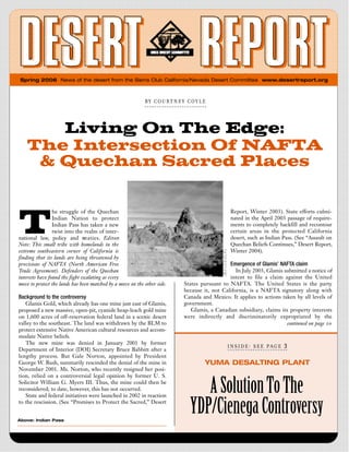
T
he struggle of the Quechan Report, Winter 2003). State efforts culmi-
Indian Nation to protect nated in the April 2003 passage of require-
Indian Pass has taken a new ments to completely backfill and recontour
twist into the realm of inter- certain areas in the protected California
national law, policy and tre a t i e s . E d i t o rs desert, such as Indian Pass. (See “Assault on
Note: This small tribe with homelands in the Quechan Beliefs Continues,” Desert Report,
extreme southeastern corner of California is Winter 2004).
finding that its lands are being threatened by
provisions of NAFTA (North American Free Emergence of Glamis’ NAFTA claim
Trade Agreement). Defenders of the Quechan In July 2003, Glamis submitted a notice of
interests have found the fight escalating as every intent to file a claim against the United
move to protect the lands has been matched by a move on the other side. States pursuant to NAFTA. The United States is the party
because it, not California, is a NAFTA signatory along with
Background to the controversy Canada and Mexico. It applies to actions taken by all levels of
Glamis Gold, which already has one mine just east of Glamis, government.
proposed a new massive, open-pit, cyanide heap-leach gold mine Glamis, a Canadian subsidiary, claims its property interests
on 1,600 acres of off-reservation federal land in a scenic desert were indirectly and discriminatorily expropriated by the
valley to the southeast. The land was withdrawn by the BLM to continued on page 10
protect extensive Native American cultural resources and accom-
modate Native beliefs.
The new mine was denied in January 2001 by former
I N S I D E : S E E P A G E 3
Department of Interior (DOI) Secretary Bruce Babbitt after a
lengthy process. But Gale Norton, appointed by President
George W. Bush, summarily rescinded the denial of the mine in YUMA DESALTING PLANT
November 2001. Ms. Norton, who recently resigned her posi-
tion, relied on a controversial legal opinion by former U. S.
Solicitor William G. Myers III. Thus, the mine could then be
reconsidered; to date, however, this has not occurred.
State and federal initiatives were launched in 2002 in reaction
A Solution To The
to the rescission. (See “Promises to Protect the Sacred,” Desert
Above: Indian Pass
YDP/Cienega Controversy
2. B Y P A T T Y A N D E L D E N H U G H E S
THANK YOU FROM PATTY AND ELDEN
Desert Report’s New Managing Editor
I
t is with a great deal of pride that we turn over the man-
SPRING 2006 IN THIS ISSUE agement of the Desert Report to desert activist, Craig
Deutsche. Craig will be in capable hands, as Judy
Anderson, Andrea Leigh, Ann Ronald, and Jason
THE INTERSECTION OF NAFTA & QUECHAN SACRED PLACES ..................1
Hashmi will continue their time and efforts in ensuring that the
DESERT REPORT’S NEW MANAGING EDITOR ............................................2 Desert Report continues to be a publication that the
California/Nevada Desert Committee and the Sierra Club can
A SOLUTION TO THE YDP/CIENEGA CONTROVERSY ..................................3 be proud. Every issue of the Desert Report is truly a team effort
and we give our thanks and gratitude to these behind-the-scenes
contributors. It has been our pleasure to work with them. We
have no doubt that Craig, with continued support provided by
the other team members, will take Desert Report to new heights.
We would also like to thank Kate Allen for taking on the job
of Outings chair and Outings Editor.
SURPRISE CANYON MOTORING HISTORY ..................................................4
About Craig Deutsche
SAND MOUNTAIN BLUE NEEDS PROTECTION ............................................6 Growing up in Minnesota, Craig was active in scouting and his parents
were active in a number of community causes. These circumstances
DONNA AND LARRY CHARPIED HONORED ................................................7 ultimately led to his involvement in desert activism. Before this, how-
ever, there were side tracks. Upon arriving in California, Craig was a
NEWS UPDATES ........................................................................................7
member of the chemistry faculty at UCLA for several years, and then
GRASSLANDS OF CALIFORNIA ..................................................................8 began a long career as a high school science teacher. His wife, Mary, is
a pediatrician, who has assisted in leading several national Sierra Club
trips in Alaska. It was not until their two children entered college that
Craig found time to lead national Sierra Club trips, lead outings for the
Desert Survivor organization, and to lead for the Desert Committee.
As local desert trips became more frequent, he has become involved with
a variety of service projects coordinated with the Bureau of Land
Management. For several years, he has been Outings Chair for the
PIPES CANYON: ALL IN A DAY’S WORK ......................................................12
Desert Committee and has written a number of articles for the Desert
MOJAVE DESERT IMPACT NEAR LAS VEGAS ............................................13 Report describing places that he has visit-
ed and loves. Retirement has now
taken him into the desert and into
desert activism on a full time
basis. Although initially a bit
apprehensive about taking over
the management of Desert Report,
NEVADA WILDERNESS DESIGNATED BY CONGRESS..................................14 Craig looks forward to the new
challenges it will bring, particularly
ONCE THEY CALL IT “PARADISE” KISS IT GOOD-BYE ................................16 following in the very large foot-
prints cast by Patty and
KELSO DUNES TO HALLORAN SUMMIT BACKPACK ..................................18 Elden Hughes.
OUTINGS....................................................................................................20 Craig Deutsche, new CEO of Desert Report.
{ 2} DESERT REPORT SPRING 2006
3. BY DAV ID S. “S ID ” WI LS O N , J R.
YUMA DESALTING PLANT
A Solution To The
YDP/Cienega Controversy
Editors’ note: Previous articles related to this subject are listed at the end
of this article. The Problem: Agricultural drain waters from Wellton-
Mohawk fields near Yuma, Arizona and pumping from the shallow
aquifer at Yuma once dumped brackish water into the Colorado River.
It is too salty for Mexican ag r i c u l t u re. It is now put in the
Wellton-Mohawk bypass canal where it flows into Mexico. This brack-
ish water has built and sustains vast wetlands in Mexico including the
Cienega de Santa Clara which forms a vital link in the Pacific Flyway.
The Yuma Desalting Plant (YDP) was built by the U. S .
government to purify the Wellton-Mohawk water and use it for
Mexican agriculture. This use would doom the Cienega de Santa Clara
and has been fought by environmentalists.
W
ater users and environmentalists have coop-
erated in developing a plan to operate the
Yuma Desalting Plant (YDP) without caus-
ing harm to, or keeping water from, the
Cienega de Santa Clara. The Cienega is a wetland that is home
to 95 bird species as well as the endangered Yuma Clapper Rail.
The plan produced by the YDP/Cienega Workgroup calls for
voluntary and compensated water forbearance when dictated by
drought conditions, pumping poor quality groundwater in the Aerial view of the Yuma Desalting Plant
Yuma area, operating the YDP and upgrading its capability to
produce a municipal-quality water supply and monitoring and
maintaining the habitat at the Cienega. Cherry, Area Manager for the Bureau of Reclamation; Herb
“We usually get left criticizing after the fact,” said Jennifer Guenther, Director of the Arizona Department of Water
Pitt, Senior Resource Analyst for Environmental Defense Fund. Resources; Michael Cohen, Senior Research Associate for the
“Because the conservation groups were included in this effort Pacific Institute; Roger Gingrich, Water Resources Coordinator
from the start, and the Workgroup reached consensus, we can for the City of Yuma; Peter Culp, Project Manager and Attorney
support the recommendations.” for Programs for the Sonoran Institute; Patrick Graham, State
Early on, it became clear that the only way to solve the pro b- Director of The Nature Conservancy in Arizona; Thomas Carr,
lem of the Cienega’s water supply while getting the Yuma Desalter Assistant Dire c t o ry Statewide Conservation and Strategic
into operation was to get a coalition of interested parties together Planning for the Arizona Department of Water Resources; and
to work out a mutually agreeable solution. That meant bringing Larry Dozier, Deputy General Manager of Central Arizona
to the table seemingly disparate parties which would mean re p re- Project. In addition, Her Dishlip (retired Deputy Director of the
sentatives from environmental groups as well as water supply Arizona Department of Water Resources) facilitated the working
people. After all, we all have a stake in producing enough water group. Each member was an expert on some aspect of the
for people, and we also have a stake in making sure that the Colorado River.
Cienega survives. So creating the work group just made sense. The controversy over the Cienega between water users and
Drawing up a list was not easy but after some time, and dis- environmentalists developed when water users began to call for
cussion with others, the people we needed for the workgroup the Bureau of Reclamation (BOR) to resume operating the YDP
received invitations. Along with Jennifer Pitt, I also invited Bill in order to reduce the drawdown of Lake Mead caused by diver-
Rinne, Deputy Commissioner of the Bureau of Reclamation; Jim sions of water in excess of Mexico’s allocation. Environmentalists
continued on page 11
DESERT REPORT SPRING 2006 { 3}
4. B Y T O M B U D L O N G
Surprise Canyon
Motoring History
The Summer 2005 issue of Desert Report tainside, most impractical to penetrate
described the Environmental Impact Statement except on foot. And, Surprise Canyon itself
being prepared to analyze the impact of extreme had become a near impossible barrier.
four- wheeling in Surprise Canyon in the Some motor bike tracks leading into the
Panamint Mountains. Readers requested more cascades were noticed, but the tracks didn’t
background on the four-wheeling story. continue above.
I
The first inklings of renewed motor-
t was the flash flood of 1984 that ized activity were around 1990. BLM
revealed a diff e rent picture of rangers reported willow trees and cotton-
Surprise Canyon and stirred feel- wood branches above the falls had been cut
ings that management needed to and removed, the bedrock in the cascades
change. For a hundred years before, miners had marks of vehicle activity, and the deep-
had gravel-filled the now famous Surprise Canyon Falls-a half est holes in the cascades had been filled with rock debris to facil-
mile of ragged bed-rock cascades. Without the fill there would itate vehicle passage. Drill holes in the bedrock had appeared, to
have been no road, and I would suspect modern users were not receive iron bars for winch anchors.
aware of the cascade buried by the roadbed. (Does Goler Wash, The Surprise Canyon and its newly revealed waterfall had
a roughly similar canyon ten miles south, hold a similar secret?) been discovered by afficionados of Extreme Four-Wheeling.
Trees were cut and vegetation was removed to accommodate They had figured out how to get through the falls that had been
vehicles and mining equipment. Apparently in the early years it considered impassible.
was strictly mining business. Tourist traffic grew later after most
mining ceased and Panamint City began to age and areas were
abandoned. Mining kept the road open until that 1984 event.
In 1980, before the ‘84 flood, the wilderness qualities of the
surrounding area were recognized by BLM in the Surprise
Canyon Wilderness Study Area (WSA) WSAs are supposed to
preserve an area until Congress makes a decision for or against
permanent designation as Wilderness, at which time the WSA
status is removed. When the flood happened, it was a WSA. To
accommodate the small remaining mining operation at the
Panamint City site, the Surprise Canyon road was left as a
cherry-stem route, bisecting the WSA. The area was also desig-
nated as the Surprise Canyon Area of Critical Environmental
Concern in the California Desert Plan.
As a WSA, the Bureau of Land Management, was responsible
for monitoring the area for off-road activity in the post-flood
roadless canyon. BLM gave the non-existent road a route num-
ber (P71) just after the flood, while some staff took their respon-
sibility seriously, regularly visiting the canyon and noting almost
no activity nor impacts on the surrounding area. Most of the
WSA is self-governing, since it’s steep, desiccated, desert moun- Hikers in Surprise Canyon
{ 4} DESERT REPORT SPRING 2006
5. Extreme four wheeling ment. At the time of this writing, the gate remains in place. In the
Extreme four-wheeling, sometimes called rock-crawling, is an ensuing 4 1/2 years the canyon has seen a spurt of riparian
exciting and interesting sport for those with the skill and inclina- growth and renewed wildlife. A series of flash floods, large and
tion. It combines problem solving, critical judgment and physical small, has totally eradicated the route the 4WDs used, from the
effort. It also requires mechanical skill, since the vehicles are canyon entrance below Chris Wicht camp to above the highest
highly modified, and only the various parts and components are spring, Brewery. Deep cutbanks caused by wheel ruts that cap-
available on the market-complete machines are not a retail item. tured the stream are slowly healing. From Brewery Spring to
Almost all participants construct or modify their own crawlers, Panamint City the old vehicle route is still visible as a vehicle-
and each turns out different. Vehicle damage is highly probable wide pathway, but without vehicle tracks.
on any outing, so spare parts and fluids are necessary, along with
ability to repair damage during and after an outing without Request for a key to the gate.
breaking the family budget. One might wonder what would Three private landowners, leftovers from the mining days,
motivate someone to spend a day ‘driving’ a route you could walk remained in Panamint City. The court order that banned
in a half hour, just to see if it could be done. The analogy is rock extreme 4WDing until completion of the EIS allowed vehicle
climbers, who spend an afternoon scratching their way up a access by these owners, in consideration of their mining rights.
vertical wall that would take ten minutes to walk up from the Since the closure, two small (5 Ac) parcels have been transferred
other side. to two groups of extreme 4WDers. With the idea that the court-
The most capable vehicles have a short wheelbase, oversized o rd e red vehicle access rights of the previous owners have
tires, extremely low gearing for low-speed crawling, locked dif- transferred with the property, the new owners have asked the
ferentials to control wheel spin, suspensions modified for huge BLM for a ‘key to the gate’, to allow them vehicle access to their
vertical wheel travel, and a winch to pull the steepest stretches by newly acquired property. To date the BLM has not granted
anchoring to a tree or rock. Less capable vehicles have made it permission.
through the Surprise falls, but only after rock fill had been
thrown into the deeper holes, and with the help of winches. The Tom Budlong is the Desert Committee’s Coordinator for the Inyo and
next flash flood might scour out the rock fill, putting the route Panamint Mountain Ranges
back on the extremes list.
A trip like this is difficult to visualize, but the four-wheelers
have helped by putting some of their trips on websites.
To see what the process looks like, visit these web sites:
• http://www.4x4now.com/trcasc4.htm or http://www.offroad.com/
toyota/pandays00.html
• http://www.twistedaxle.com/trip/trip/121200pvd2k.html
If you would like to see the canyon without 4WDs visit: Death Valley
• http://www.endangeredearth.org/slideshows/SURPRISE/index.htm National Park
The BLM began allowing trips by extreme 4WD groups after
1991. The annual Panamint Valley Days outing regularly
included a winching trip through the falls as one of their activi-
ties. Organizations such as the Bakersfield Trailblazers and CAL
4WD were involved.
Closure in 2001
Environmentalists, alarmed by the increased vehicle activity,
and concerned that a rare desert riparian biological island was in
danger, reminded the BLM of their responsibilities. The Center
for Biological Diversity brought suit against the BLM for
neglecting Surprise Canyon, and for management lapses in other
areas. BLM negotiated an agreement to analyze the impact of
driving in the canyon with an Environmental Impact Statement
(EIS). In May of 2001, a gate was erected at the canyon entrance
opposite Chris Wicht camp, and ‘No Vehicles’ signs were post-
ed. Since then, there have been complaints from the extreme
4WD community, but no vehicles have been in the canyon. The
EIS is in process, but has not been publicly released for com-
DESERT REPORT SPRING 2006 { 5}
6. B Y D A N I E L P A T T E R S O N
SHRINKING BUTTERFLY HABITAT
Sand Mountain Blue Needs Protection
I
n the desert east of Fallon, Nevada, in dunes which are
receiving increased use by off- road vehicles, lives a
small blue butterf l y, the Sand Mountain blue. In
January, the Center for Biological Diversity (CBD) and
two other groups filed a lawsuit in federal court against the
Department of Interior (DOI) for failing to consider protection
of this endemic species, which lives only in the Sand Mountain
Dunes on Bureau of Land Management (BLM) lands.
This action followed up from a 2004 scientific petition to
DOI Secretary Gail Norton to list the Sand Mountain blue but-
terfly (Euphilotes Pallescens Arenamontana) as a threatened or
endangered species under the Endangered Species Act, and to
designate critical habitat for its conservation and recovery.
Inaction on the petition for over a year (the law requires
action within 90 days) motivated the litigants to seek an order
forcing the Secretary to issue a “finding” on the petition. Daniel
Patterson, speaking for CBD said, “ A ‘positive finding’ is war-
ranted as the petition presents significant information, and would Sand Mountain Blue Butterfly
start a species status review and likely proposed Endangered
Species Act listing.” increase has contributed to a dramatic increase in the number of
off-road impacts through the Sand Mountain Blue habitat.
Endemic species more prone to extinction
The butterfly is dependent on approximately 1,000 acres of Buckwheat destroyed by recreational impacts
Kearney buckwheat shrub habitat at the Sand Mountain Dunes, The Kearney buckwheat was once pervasive in the vicinity of
which is intensively impacted by off-road vehicles. Given their the dunes, but in the past five years most plants have been
restricted geographic ranges, endemic species are more prone to destroyed by ORVs. The key to preserving the Sand Mountain
extinction than widespread species. blue butterfly is to ensure the continued existence of its host
“BLM has responded shamefully to an environmental emer- plant, Kearney buckwheat, in large enough numbers to maintain
gency, ignoring its own data that shows habitat for this species is a viable population of the butterfly.
being decimated by recreational excesses. And the Fish and Editors Note: Habitat protection for an endemic butterfly species is
Wildife Service, the agency that is supposed to act in such cir- not an unprecedented action. In Los Angeles, the endangered El
cumstances, is itself AWOL,” says Karen Schambach of Public Segundo blue butterfly lives on the sand dunes behind the beaches west
Employees for Environmental Responsibility . of Los Angeles International Airport. The entire area is fenced in, with
Sand Mountain Recreation Area (SMRA) consists of 4,795 visitors permitted only on foot with a guide for short periods of time.
acres of BLM public lands open to unrestricted off-road vehicle Like the Sand Mountain blue, the El Segundo blue requires a
(ORV) use. Sand Mountain’s small size, lack of strong protection distinct species of buckwheat found only within sight of the ocean.
m e a s u res, and relative closeness to cities in Nevada and BLM did recently take some small steps to reduce off-road
California make it a magnet for off-roaders. Native Nations impacts, but still has kept an excessive route network spider-
nearby consider the dunes sacred and have long voiced concern webbed across the shrinking butterfly habitat. Compliance and
about ORV damage. enforcement has been spotty at best.
Habitat for the Sand Mountain blue has suffered extensive
destruction and modification from off-road vehicles. From 1993 Daniel R. Patterson is Ecologist & Deserts Program Director with the
to 2003 the BLM reported a 25 percent increase in visitor use at Center for Biological Diversity. biologicaldiversity.org, (760) 366.2232
the recreation area, and ORV use is still going up fast. This x306, dpatterson@biologicaldiversity.org
{ 6} DESERT REPORT SPRING 2006
7. 2005 MINERVA HOYT
CALIFORNIA DESERT NEWS UPDATES
CONSERVATION AWARD
Gerlach Energy Plant
Donna and Larry California policy prompts downsize in Gerlach energy plant. (See
Desert Report Spring 2005) New energy policies in California to curb
global warming are causing Sempra Energy to consider downsizing its
Charpied Honored
proposed 1,200-megawatt, coal-fired power plant project. Lassen
County (California) officials are worried whether the pumping of
groundwater would affect their ranchers. An environmental report is
underway.
D
onna and Larry Charpied have been named the Colorado River Fish Plan
recipients of the 2005 Minerva Hoyt California Inadequate
Desert Conservation Award. This prestigious
A federal judge has ruled that the recovery plan for an endangered
award is being presented inrecognition of the
leadership and perseverance of this talented couple in leading the Colorado River fish isn’t good enough. U.S. District Judge Frederick
campaign to stop the Eagle Mountain dump, a proposed massive Martone rejected the U.S. Fish and Wildlife Service plan for the
garbage dump that would have been built in the arms of Joshua
humpback chub, ruling it didn’t lay out a timeline for the fish popula-
Tree National Park.
Donna and Larry moved to the Eagle Mountain/Desert tion’s recovery and didn’t allocate any money to get the job done.
Center community in 1982 to research and develop jojoba. A The government must now rewrite the plan to include more
renewable resource indigenous to the area, jojoba produces an oil specific goals and lay out a timeline for recovery. The humpback chub
that is nearly identical to sperm whale oil. The Charpied’s
certified organic farm has been recognized world-wide in the population in the Grand Canyon has gone down by about two-thirds in
industry. the past 13 years, from 10,500 in 1989 to 3,500 in 2002.
Beyond fighting the dump proposal, the Charpieds are chal- The groups suing, strongly opposed a part of the plan that would
lenging the Metropolitan Water District plan for an Upper
count the population as recovered if there were 2,100 adult fish, lower
Chuckwalla Valley “Water Storage” Project that would pump the
Pinto Basin’s underground water supply into the Colorado River than when the species was listed as endangered.
Aqueduct. They are members of the Coalition to Save Shavers
Valley. They have created a new campaign called “Give It Back!”
Bighorn Sheep Again Seen
to enforce the return of 29,775 acres, including the Kaiser min-
ing site, to the park under the terms of the In Jacumba Wilderness
mining company’s original agreement It has been a long time coming, but bighorn sheep are repopulating the
with Congress.
Jacumba Wilderness and have even been seen from I-8. It has been
The Minerva Hoyt Californ i a
D e s e rt Conservation Aw a rd is the belief that Border Patrol activities drove the sheep out. It appears
named after a 1920-era that a better trained Border Patrol and policies of restricting Border
Pasadena socialite whose
Patrol vehicles in Wilderness is paying off.
activism is credited with pre-
s e rving land that is now
Joshua Tree National Victory For Hi-Desert
Park. It was through the Communities Against
e ff o rts of Minerva Hoyt
ORV Abuse
that President Franklin
Roosevelt on April 10, San Bernardino County Yucca Valley Sheriff’s Off Road Ve h i cle
1936 established the Enforcement Grant of $67,000 gets final approval by the State Off
825,340-acreJoshua Tre e
National Monument. Highway Vehicle Commission. (See Desert Citizens Fight Back Against
Minerva Hoyt would Illegal ORV Abuse. Desert Report Winter 2006). This grant will provide
be proud of the the equipment needed by the Sheriff’s Department to begin to control
Charpieds. Certainly the
illegal ORVers.
Desert Committee is!
DESERT REPORT SPRING 2006 { 7}
8. B Y B R E C K M c A L E X A N D E R
EXOTIC WEED INVASION
Grasslands
Of California
T
hey are lush green carpets with riots of wildflowers When the droughts abated in the mid-1860s, the effects of over-
in late winter through spring and golden blond grazing, combined with the sustained drought, decimated
landscapes of yellow sunflowers and tarweeds from California’s understory vegetation and primed the landscape for
summer through fall. California grasslands make heavy erosion from the winter rains.
up much, if not most of the undeveloped and uncultivated land
left in the state. From a distance, they don’t look any different Weed biology and spread
than they would have 150 years ago – but on closer inspection, The introduced Eurasian vegetation has a cool-weather
their true composition is very different. In fact, California’s active, summer dormant, annual habit that allowed it to rebound
beautiful rangelands have been invaded by exotic weeds! quickly to landscape disturbances. The perennial, slower grow-
ing native grasses were relatively powerless in defending their
A piece of history original claims to California’s grasslands.
What did California foothill and valley grasslands really look By 1860, there were at least 91 alien weeds naturalized in the
like a hundred and fifty years ago? Nobody alive knows for sure state, and they began to swiftly dominate the grassland landscape.
because early European travelers were untrained as botanists and Cultivation, with its greatest extent during the 1880s, exacerbat-
plant geographers, but historical accounts describe vast expanses ed this land conversion with the tillage of dry-land farming
of tall grasses. In 1848, John C. Fremont wrote of tall grass methods that preceded extensive irrigation. Today, there are
prairies in the Sierra Nevada foothills and inner Coast Ranges. more than 1000 naturalized plants in the state, including about
He spoke of an area near the site of present day Sacramento, with 175 species of introduced grasses. And while there are a total of
grass that was “smooth and green” among open groves of large about 300 native grass species found in California (including
oaks. In February of 1828, Jedediah Smith wrote, “The whole annuals), on average 90% or greater of the plant cover and bio-
face of the country is a most beautiful green, resembling a flour- mass of grasslands are made up of exotic weeds. This percentage
ishing wheat field.” is somewhat lower in northern and coastal California due to
Most plant-smart people find it aggravating that the aggres- higher precipitation totals, milder climates and a reduced history
sive “foxtail” type grasses that burr into their socks and ankles of tillage. But less than 2 percent of the original native grassland
really don’t belong here (such traits helped make non-native
grasses so successful!). The wild oats, cheatgrass, ripgut, and red
bromes are not American natives at all. Their introductions
occurred as part of the Columbian invasion of North America
beginning in the mid-1500s. Many of the invading grasses and
forbs really are barnyard weeds of southern France, Spain,
Portugal and Great Britain. Their seeds came to America both
deliberately and as stowaways with conquistadors, Jesuits and pil-
grims.
Several plants brought to the New World are extraordinary
additions to the state’s general welfare and productivity. Such
beneficial plants include wheat, wine grapes, and olives. But such
accolades cannot be given to the invasive weeds that were export-
ed from the Eurasian regions beginning with the Columbian
conquest of the New World.
After cattle introduction to San Diego by the Spanish in 1769,
livestock–cattle and sheep–became ubiquitous on the California
landscape by the 19th century. Grazing was probably most
intense during the 1850s in order to supply meat for the bur-
geoning gold rush. During this time of range overstocking, there
was a long period of sustained drought (1840s though early 60s). Native Bunch Grass
{ 8} DESERT REPORT SPRING 2006
9. remains in California today, making it one of the rarest habitats SUPERIOR ATTRIBUTES OF
in North America, if not the world. NATIVE GRASSES
Benefits of native grassland
Native grasses make excellent wildlife habitat, providing cover, high
Many, if not most, non-native grasses were deliberately
brought into the western U.S. as forage for livestock. Pioneering quality forage, and nutritional seed crops, encouraging and supporting
Europeans were quite familiar with them. It must be said that a highly diverse assemblage of fauna.
they have and do play the dominant role as range fodder for live-
stock today. However, in the absence of overgrazing, natives
Some native perennial bunchgrass plants are thought to be a hundred
probably are at least as valuable as non-native grasses in that
respect. In fact, livestock have been shown to feed preferentially years old or more. This inherent longevity is, in part, a result of deep
on native perennials, which may be available for a longer period root systems. The deep root systems are very important for erosion
of time. Most of the introduced annuals mature early in the sum- control purposes.
mer with long stiff awns that repel grazers. Others have lower
nutritional value than native grasses, and so are not preferred
The spacing between plants of native perennial bunchgrasses is
when better food sources are available.
greater than introduced annuals, and the perennial vegetation does not
Prospects for the future die completely every year. As a result, there is less accumulation of
Leading individuals in this conservation effort, and their stu- humus or fuel on the ground, making it less likely to carry a wildfire
dents, such as Mark Stromburg at the University of California’s than in annual grasslands. Fires that do occur in landscapes dominat-
Hasting Natural History Reservation, John Menke and Kevin
Rice of U.C. Davis; Paul Kephart of Rana Creek Habitat ed by native grasses are smaller, less intense, and of shorter duration.
As a consequence of greater spacing between plants, there is greater
access to the ground surface for native fossorial animals, such as
The introduced Eurasian vegetation has kangaroo rats, antelope ground squirrels, mice, voles and blunt-nosed
a cool-weather active, summer dormant, leopard lizards. The greater spacing has been shown to enhance many
annual habit that allowed it to of the animals’ activities. The spacing that benefits fossorial animals
promotes better fertility of the soils, as the animals continue to churn
rebound quickly to landscape disturbances. it over.
The perennial, slower growing native grasses
Perennial bunchgrass spacing has been shown to slow and reduce
were relatively powerless in defending their moisture and nutrient losses from soils to a greater extent than
original claims to California’s grasslands. in annual grasslands. This may allow for more diverse populations
of plants.
Restoration, John Anderson of Hedgerow Farms, and the ...Such a high degree of functionality is a result of eons of association
California Native Grassland Association have made great strides with local climates, landforms and other flora and fauna.
in research and promotion of California’s native grasslands.
These researchers have discovered ways of shifting the com-
petitive balance in favor of native grass dominance. They have
developed management techniques that promote resistance to
later invasion by non-natives. Such accomplishments give high
hopes for the prospects of preserving and enhancing the remain-
ing stands of native grasses of California in the future.
Today, Californians have the hindsight to understand some of
the disastrous ecological mistakes of the past. Given that, will we FOR MORE INFORMATION
have the foresight to preserve our native grass habitats and return
them to their former functionality and aesthetic grandeur? Or Hastings Biological Field Station, University of California, Museum of
will we let the remaining 2 percent continue to slide into a final Vertebrate Zoology and Natural Reserve System:
obit of history? www.hastingsreserve.org
Navigate to Natural History, then Native Grasslands
Breck McAlexander is an ecologist and environmental consultant in
Northern California. He can be reached at breckm@peoplepc.com California Native Grasslands Association:
www.cnga.org
DESERT REPORT SPRING 2006 { 9}
10. Living On The Edge: The Intersection Of NAFTA And Quechan Sacred Places
continued from page 1
California mining laws and regulations. It seeks over $ 50 million dispute may well bring such issues to center stage. Some
in damages. Glamis has stated it chose NAFTA over filing a claim researchers have argued that human rights obligations could be
in domestic courts, because it did not want to be a Canadian com- used to mitigate the level of damages owed. Quechan defenders
pany suing the State of California in California courts. believe that such obligations, legitimate objectives of public
Because the parties were unable to reach agreement, six interest, can be used to further justify the challenged measures to
months later Glamis filed a claim under the contro v e r s i a l completely defeat a claim.
NAFTA Chapter 11 provisions. This provides for a private tri- Discovery is allowed only between the parties, but is not avail-
bunal to hear the disagreement, which is similar to arbitration. able to non-disputing parties. Moreover, the record is often
Glamis is quick to state it is not seeking approval of its mine or closed to non-parties. Yet, the rules of engagement appear more
elimination of the California measures, but rather seeks only flexible in many respects than that of domestic courts. Further,
“just compensation” for alleged financial losses. The State the only parties recognized as having a right to participate in the
Department, responsible for defending these claims for the arbitration are the responding government and the claimant. A
United States, asserts on its website that it will vigorously defend nonparty may not intervene; it may only ask permission to file a
against the claim. friend of the court brief.
Under NAFTA, each party selects one arbitrator, and they
Negotiated solution effort fails
After the NAFTA claim was filed, Glamis and the Tribe
explored the potential for a negotiated solution by a process sim-
ilar to that successfully used in the mid-1990’s during the Clinton
It is the Tribe’s view that human Administration to retire mining claims at the New World Mine
rights norms are relevant when outside Yellowstone National Park-using the President’s Council
on Environmental Quality (CEQ) to assist in reaching a solu-
interpreting the provisions of an investment tion.
Despite these efforts and those of the National Trust for
treaty and the reasonableness of the Historic Preservation, who were successful in acquiring the oil
and gas rights in another case, DOI was not supportive of the
challenged measures. To do otherwise, would effort, and CEQ choose not to get involved. This inaction result-
be to allow investment principles to trump ed in the continued NAFTA process, which is all about money,
not resource protection.
human rights principles by default. Environmentalists and others are concerned that a decision
requiring the United States to compensate Glamis could put
pressure upon California to try to rescind the mining measures.
jointly attempt to agree upon its Chairperson. When agreement The tribe’s submission is accepted
cannot be reached, a World Bank official will select the Chair. More recently, in August 2005, the Quechan appealed to the
Glamis’ claim is being heard under the “Additional Facility tribunal because it felt that neither party could adequately pres-
Rules.” While there are standards of experience and profession- ent the Tribe’s governmental, religious or cultural interests in
alism imposed on the selection of arbitrators, it does not require this matter. The Tribe’s brief underscored the nature of the cul-
them to possess a background that might be appropriate for a tural resources and sacred places at issue in the claim, the Tribe’s
particular dispute, such as in environmental, mining, Indian or view of the unusual permitting history for the mine, the mine’s
human rights law matters. severe environmental impacts, the intent behind the California
There is no requirement for either the State Department or measures, and the domestic and international legal and policy
Glamis to make a selection of a chairperson or arbiter who is frameworks supporting indigenous cultural resource protection.
either an Indian or a human rights expert. Cultural rights are The United States supported the Tribe’s effort; Glamis, on
widely recognized as human rights. the other hand, disagreed, yet deferred to the Tribunal on
As now constituted, the Tribunal Chair has worked on whether to accept the submission. In September 2005, the
international religious freedom issues; another member is a Tribunal formerly accepted the Tribe’s briefs. The Tribe’s friend
professor at Boalt Hall, the UC Berkeley School of Law, and was of the court submission is reportedly the first to be accepted
editor-in-chief for Ecology Law Quarterly; the third is a retired f rom Native Americans in any international economic law
international law firm partner. However, the depth of their dispute.
understanding of the sacred nature of the resources and the pro- It is the Tribe’s view that human rights norms are relevant
found and compelling need to protect them, and the legitimate when interpreting the provisions of an investment treaty and the
environmental rationale behind the California measures, remains reasonableness of the challenged measures. To do otherwise,
to be seen, as no substantive rulings have been made to date. would be to allow investment principles to trump human rights
The extent to which human rights law may be considered by principles by default.
tribunals remains mostly the subject of academic debate. This
{ 10 } DESERT REPORT SPRING 2006
11. YDP/Cienega Controversy
continued from page 3
Next steps feared the YDP operation would stop treated and become part of the U.S.
Next, the parties will conclude dis- flows of water to the Cienega. deliveries, saving U.S. water users up to
c o v e ry Then, each will submit their
. “Our concern is that if that happened, 100,000 acre-feet of Colorado River
briefs, and other non-party submissions the Cienega would be lost,” said Graham of water currently lost from the reservoirs
may be made. A hearing is not expected The Nature Conservancy. “We felt it was each year. However, it also meant the
until December 2006. Witnesses may be critical to preserve that precious habitat.” water currently going to sustain the
called at the hearing. So far the United A treaty with Mexico calls for the Cienega would be severely curtailed or
States has not lost a single case under U.S. to give Mexico 1.5 million acre-feet stopped with brine waste flowing to the
these NAFTA provisions and has not of water each year and also states the wetland instead.
paid a penny to date. salinity level or salt content of the water The YDP/Cienega Workgroup met
If Glamis does not prevail, it is must not exceed a certain level. As the over the course of nine months and
unclear what its next move might be. If it Colorado River flows downstream it developed a white paper, Balancing Water
does prevail the Tribe has asked the picks up salts from naturally occurring Needs on the Lower Colorado Rive r :
Tribunal to make a finding that the geologic contributions and agricultural Recommendations of the Yuma Desalting
claims have no value so that Glamis return flows which leach salt out of the Plant/Cienega de Santa Clara Workgroup.
could not benefit by both receiving a The paper provides potential solutions to
monetary award and retaining its claims the dispute that accommodate the needs
for use or sale, thereby perpetuating the of water users without harming the envi-
mining threat to the sacred area. ronment. The complete report can be
To ignore the cultural rights of this
Early on, it became clear found at CAP’s website: www.cap-
dispute may have the unintended conse- that the only way to solve az.com. Once at the web page, click on
quence of expropriating state – and the critical issues icon which is pictured
tribal – sovereignty. The Quechan hope the problem...was to as a triangular sign with an exclamation
that their efforts will not only help pro- point. That takes you to a listing of arti-
tect Indian Pass but also serve as a para- get a coalition of interested cles and papers. The YDP paper is avail-
digm and precedent to assist other able in both English and Spanish.
indigenous peoples to make their voice
parties together to The paper has a series of ways to both
heard in international trade disputes. work out a mutually preserve the Cienega and operate the
YDP. Some of the solutions are short
Courtney Ann Coyle,is an attorney for the agreeable solution. term and can be implemented quickly
Quechan Indian Nation protection. She can and other measures will take more time.
be re a ched at CourtCoyle@aol.com. The Jennifer Pitt summed up the results of
Q u e chan Nation can be re a ched at: the workgroup.
760.572.0213 (government) or 760.572. land and into the river. The YDP was “Interested parties have come togeth-
0661 (cultural). authorized by Congress and built by the er and developed sensible solutions that
BOR to remove salt from the water that accommodate the needs of water users
Thank you to Barrister & Solicitor Todd flows into Mexico. without harming the environment,”
Weiler for his contributions to this article. Return flows from the Wellton- she said. “It now is up to the federal
Mohawk Irrigation and Drainage government and other entities to make it
District (WMIDD) is especially salty. An a reality.”
FOR MORE INFORMATION interim solution was to simply divert the
WMIDD water into Mexico through a David S. “Sid” Wilson, Jr. is the General
bypass channel which flows into the Manager of the Central Arizona Project
To read the NAFTA submissions in this
Santa Clara slough. This was done and
matter, including those of the Tribe, visit
the result was the dramatic expansion of Editors’ note: Desert Report has described the
the United States Department of State
the wetland now called the Cienega de Lower Colorado River and Delta in prior
website at:
Santa Clara. issues: Ecosystems Re-created, Dr. Edward
http://www.state.gov/s/l/c10986.htm
With the recent drought, water users Glenn, spring ‘02; Miraculous Rebirth,
For additional material on this claim and began to call for restarting the YDP Jennifer Pitt, Spring ‘02; A Multispecies
NAFTA in general, visit because the approximately 100,000 acre- Plan in Jeopardy, Steve Glazer, Spring ‘02;
http://naftaclaims.com. feet of WMIDD drain water which is Is the Lower Colorado River Doomed?,
diverted to the Cienega was too salty to Jennifer Pitt, Summer 05; All American
Editors note: See also Luke Eric Peterson’s qualify as part of the U.S. treaty obliga- Canal Brings International Litigation,
paper http://www.iisd.org/publica- tion to deliver 1.5 million acre-feet to David Czamanske, Winter ‘06.
tions/pub .aspx?pno=577 Mexico. Operation of the YDP would
mean the WMIDD water would be
DESERT REPORT SPRING 2006 { 11 }
12. BY APRIL SAL L
RARE DESERT WATERSHED
Pipes Canyon
All In A Day’s Work
I
am jostling along a ru g ged and rocky Side canyons and drainages reveal more
canyon road. It is mid-afternoon and I springs and seepages that make this pre s e rv e
have maneuvered up the extremely i n c reasingly valuable to the arid flats below.
narrow, boulder strewn 4x4 tra ck to The year-round wetlands support an
fix a gate along our we s t e rn boundary. The area abundance of mountain and desert wildlife
is dusted with light snow. Transitioning back including bears, bobcats, cougars, and mule
down to the wa rm hi-desert entrance of Pipes deer. After the plentiful rain in the 2004/05
C a nyon, I detour to check on some key properties winter, the stream at Pipes Canyon continues
that flank the surrounding volcanic mesas. I then to run above ground providing unexpected
hike into the nearby wash to look for tracks: ani- wildlife viewing opportunities. Red-tail
mal, human or machine. I pause, thinking of the dive rse places I have hawks and golden eagles roost in the pinons above, awaiting a field
been today. Back at the Ranger Station, I walk past a group of hike rs mouse or ground squirrel to emerge for a drink. On occasion an
studying the visitor kiosk. We exchange greetings, and I am asked about e n d a n g e red desert tortoise can be seen meandering through the
the story of Pipes Canyon Pre s e rve. lowlands at the pre s e rve entrance.
E d i t o rs Note: If this is the sort of day that appeals to you, then you The lush canyon ridges cast shade on the canyon floor, bring-
might find that being a ra n ger on a pre s e rve is your dream job. Even if ing coolness and a sense of peaceful isolation to visitors and
you don’t relish doing this sort of thing day after day, even a short visit wildlife. Ascending these ridges to Chapparosa peaks above pro-
can give you a taste of the remarkable features of this private pre s e rve. vides breathtaking panoramas of the majestic volcanic mesas and
continued on page 22
Pipes Canyon, one of the regular locations of Desert
Committee meetings, is located in a transition zone varying fro m
4,400 to nearly 8,000 feet in elevation. Pipes Canyon support s
both desert Joshua Tree and Pinyon-Juniper woodlands ecosys-
tems intermixed with manzanita, chemise and oaks. It is the head-
q u a rters for management of more than 40 square miles of land
owned by The Wildlands Conservancy (TWC) in the southeast
p o rtion of the San Bern a rdino Mountains. The pre s e rve includes
strategic pro p e rties connecting the San Bern a rdino National
F o rest to the parched landscapes of the Mojave Desert, creating
wildlife corridors through water-laden canyons.
The importance of this rare desert watershed is hard to grasp.
Draining the San Bern a rdino Mountains and Mount San
G o rgonio, the watershed feeds the western Mojave Desert via the
Pipes Canyon, Little Morongo, Mission Creek, and Whitewater
drainages. All are protected by a combination TWC and federal
lands. Not all of this precious water is visible on the surf a c e .
Springs, seeps and underg round watersheds connect streams and
riparian are a s .
The diverse terrain and vegetation provide an assemblage of
Top: The Desert Committee occasionally holds meetings at
habitats and microclimates unscathed by recent human influence. the Ranger station at Pipes Canyon Preserve.
{ 12 } DESERT REPORT SPRING 2006
13. B Y G E O R G E W. P H I L L I P S
DESERT DESTRUCTION
Mojave Desert Impact
Near Las Vegas
S
ince 1966, rapidly accelerating Changes in the style of cultural site graf-
growth has been a defining fiti reflect the population pre s s u re. For
trend in Clark County, remote locations, much of the graffiti is a
Nevada. Not surprisingly, the mark that “I was here.” For those sites
surrounding Mojave desert suffers from the crowded by development, spray paint “tag-
exploding population growth and is being ging” to mark gang territory is prevalent. It
severely impacted. A handful of law reflects a personal nonattachment to price-
enforcement rangers patrol 7,900 square less, nonrenewable resources. For those of
miles, the size of Massachusetts, and land us who care deeply about the quality of gifts
managers cannot act fast enough to impede the desert offers us, we have grounds for
the destruction. anxiety. But the situation is not all grim.
Lights, gambling and adult entertainment brand the city of Land managing agencies are responding. Land managers face
Las Vegas, Nevada. The city of neon is centered in Clark County decisions with enormous importance to population demands.
and is celebrating its one hundredth birthday. Dry air, sun, swim- They endure towering financial, political and public pre s s u re and
ming pools and strip shows will attract forty million tourists this are generally under-funded as they administer large, diverse
year. Clark County, which had fewer than 7 thousand people in departments. Given these conditions, they can be easy targets for
1930, now has a population of almost 2 million. The county is the criticism, but they are responding with concern for the pre s e rv a-
destination of 60,000 new residents each year, the equivalent of tion of cultural sites. They formed a partnership among the five
adding the population of Santa Fe, New Mexico provoking crash continued on page 22
courses in conservation and land management.
Within the county are over 7,000 documented archaeological
sites, the third largest assortment of cultural sites in Nevada.
With few exceptions these sites are within an hour’s ride from
exploding population centers of Laughlin, Mesquite, and the Las
Vegas valley. In many cases, major sites such as Red Rock Canyon
National Conservation Area (NCA), Sloan NCA, the Spring
Mountains and the Las Vegas Wetlands are surrounded by, or are
adjoining, residential areas. Cultural sites are in peril.
During the first ten months of 2005, land managers respond-
ed to 25 major cultural site impacts and 35 additional impacts of
a lesser significance reported by Clark County site stewards.
These include fire pits in shelters, graffiti, vandalism, disruption
of midden piles, potting, bullet holes affecting cultural sites,
shotgun blast damage, major trash dumping, extensive off-road
destruction of sensitive soils and other illegal off-road driving.
Impacts from natural causes include lightning-caused fires and
deterioration of historic structures.
Data collection for just one year shows an alarming escalation.
For the single month of November, 2005, eight major damage
Top: Graffiti defiles ancient rock art. Above: Bullet holes
reports indicate the destruction is continuing to accelerate. permanently disfigure a remote petroglyph panel.
DESERT REPORT SPRING 2006 { 13 }
14. BY BRIAN BEFFO RT
Nevada Wilderness
Designated By Congress
I
n November, Congress designated 14 new wilderness road vehicle and wilderness management within the county.
areas totaling 768,294 acres as part of the Lincoln Ten percent would go to Lincoln County for the protection of
County Conservation, Recreation, and Development natural resources and the development of trails, parks and
Act of 2004. other outdoor recreation needs. Five percent would go to the
Although this legislation represented a huge step forward for Nevada state education fund.
protection of many extremely deserving and threatened areas, • The bill allowed more than 200 miles of public utility corri-
some of the wilderness areas are smaller than the Nevada dors, which might in the future be used for water pipelines to
Wilderness Coalition proposed, and some key areas like the bring rural Nevada’s water to Las Vegas. However, the bill
Pahranagat Range were not given the wilderness protection they contained clear language that any water decisions would be
desperately need. The US Fish and Wildlife Service’s Desert made only by the state water engineers based on the states’
National Wildlife Range was also not addressed in this bill (nor water laws and existing water rights.
was it in the Clark County legislation in 2002). This refuge holds • The bill also required a deep-aquifer water study for White
some of Nevada’s largest and wildest tracts of land in Nevada, Pine and Lincoln counties, as well as adjacent areas in western
and the conservation community will continue to push for pro- Utah. Up to $6,000,000 has been made available to fund the
tection of these key wildlands. study.
Brian Beffort is the Conservation Director of Friends of Nevada
Wilderness. Phone: 775-324-7667 Fax: 775-324-2677
In November, Congress designated Brian@nevadawilderness.org. www.nevadawilderness.org
14 new wilderness areas totaling 768,294
Welcome Lincoln County
acres as part of the Lincoln Wilderness Areas!
On November 30, 2004, the Lincoln County Conservation,
County Conservation, Recreation, and Recreation and Development Act became law, and Nevada’s
wilderness legacy grew by 14 areas and 768,294 acres. Here’s a
Development Act of 2004. brief introduction to the newest members of Nevada’s wilderness
family. If you get a chance this year, get out and say hi in person.
They’d love to meet you!
Not a wilderness bill
In addition to the wilderness designations in the Lincoln Mormon Mountains Wilderness 157,938 acres
County bill, other public lands conveyances were legislated as This complex of soaring limestone peaks and deep rugged valleys
well: is wonderful habitat for bighorn sheep, desert tortoise, the
• The bill allowed for the high-bidder auction of up to 90,000 endangered Las Vegas bearpaw poppy and numerous other
acres of BLM lands in Lincoln County (which is 98 percent species. It’s also a great landscape for exploring less than two
federal) to allow for community expansion and economic hours from the Las Vegas Valley. The Mormon Mountains
development. The county and the BLM will work together to Wilderness is the second-largest wilderness in Nevada (at
decide the specific parcels and timeline for auction, in accor- 315,700 acres, the Black Rock Desert Wilderness is the largest).
dance with the BLM’s Resource Management Plan (a draft of
which is currently available) in order to allow for more public Meadow Valley Range Wilderness 123,488 acres
input. The long north-south spine of the Meadow Valley Range offers
• Eighty-five percent of the funds generated by the land sales this wilderness area several different personalities to visitors. The
would be available for the BLM to manage land sales, archae- rugged western slope provides steep colorful cliffs and hidden
ology, multi-species habitat management planning and off- canyons, while the bajadas of the gentler eastern slope provide
{ 14 } DESERT REPORT SPRING 2006
15. habitat for numerous plant and animal species. This is now the Big Rocks Wilderness 12,997 acres
third-largest wilderness in Nevada. The steep-sided mountains, canyons and jumbled boulders pro-
vide excellent opportunities for solitude and exploration. The
Delamar Mountains Wilderness 111,328 acres ruggedness of the terrain prevents access by motorized vehicles
The deep canyons, washes, colorful cliff faces and long sloping and leaves the majority of the land pristine. This area is rich in
bajadas in the Delamars provide many opportunities for beauty rock art and primitive campsites. Big Rocks is also a Citizens’-
and solitude, as well as critical habitat for bighorn sheep, mule Proposed Wilderness, which means Congress ignored the BLM’s
deer and other sensitive species. This is now the fifth-largest faulty assessment that the area contained values unworthy of
wilderness area in Nevada. wilderness protection and designated the area anyway. It’s a won-
derful precedent and one we hope to repeat in the future.
Clover Mountains Wilderness 85,748 acres
From dusty washes draining into Rainbow Canyon south of Worthington Mountains Wilderness 30,664 acres
Caliente, the Clover Mountains rise into ponderosa pine forests Worthington Mountain rises 4,000 vertical feet above the dry
nearly 8,000 feet above sea level. The Clovers join with the valleys of central Nevada to almost 9,000 feet in elevation. The
Mormons, Meadow Valleys and Delamars to make up the “Big rugged limestone backbone of the mountain presents a difficult
Four,” 870,000 acres of wilderness, which joins the 1.6-million- challenge to visitors with heavily dissected, maze-like canyons,
acre Desert National Wildlife Range to the west to comprise one precipitous cliffs, knifelike limestone surfaces, and no surface
of the largest remaining, relatively undeveloped blocks of wildlife water. Those who persist will be rewarded by endless vistas, nat-
habitat in the Lower 48. ural arches, 2,000 acres of ancient forest, (the oldest tree dated at
2,100 years), and limestone caves, the largest being Leviathan.
South Pahroc Range Wilderness 25,800 acres
The jumbled rock outcrops and canyons of the South Pahroc Weepah Spring Wilderness 51,480 acres
wilderness area promises both solitude and challenge to anyone The Weepah Spring Wilderness in the Seaman Range offers
exploring the area. The rocky geologic features are interlaced isolated peaks, maze-like canyons, walls of fossil bearing rocks,
with stands of pinion-juniper, white fir and aspen, forming iso- natural arches, odd volcanic hoodoos and the largest stand of
lated glades that provide shady solitude. Mule deer, mountain ponderosa pine trees in eastern Nevada. Hiking, camping, back-
lion, newly reintroduced bighorn sheep, golden eagles and packing, hunting and horseback riding are good in this area of
prairie falcons can be found in the area. forest and eroded volcanic cliffs.
Parsnip Peak Wilderness 43,693 acres
P a rt of the Wilson Creek Mountain Range, Parsnip Peak
Wilderness provides remarkable recreation and solitude among
Fortification
Range riparian areas, rocky slopes and aspen forest. There are also pre-
Far South
Egana
historic sites that include campsites, rock rings, rock shelters and
rock art. Deer, elk and other ungulates browse the area, and bald
eagles like the pockets of fir which survive in craggy niches in the
higher elevations.
White
Rock
Parsnip Peak
White Rock Range Wilderness 24,413 acres
The White Rock Range contains gently rolling foothills covered
Weepah
Springs in sagebrush, pinion pine, juniper, and scattered ponderosa pines,
as well as side canyons and a high, windswept plateau covered
Worthington
Mts with aspens and pockets of white fir. Numerous springs support
grassy meadows and lush riparian vegetation important to the elk
Big Rock and mule deer in the area. Strangely eroded volcanic ash and
columnar peaks jut out over the trees and provide excellent
Mt Irish Tunnel scenery for visitors.
South Pahroc Spring
Range
Fortification Range Wilderness 30,656 acres
Clever Mountains Although most of the 14-mile-long Fortification Range is a low,
volcanic mountain range, the north end becomes very rugged and
Delamar Mts precipitous, where the rock has been eroded into sheer cliffs and
massive outcrops. These spectacular formations and cliffs form a
Meadow Valley
Ranges huge natural amphitheater at the head of the Cottonwood
Canyon drainage. Wildlife within the wilderness includes mule
Mormon Mts
deer, antelope, mountain lions, and raptors.
continued on page 17
Lincoln Cty Conservation, Recreation, & Development Act map
DESERT REPORT SPRING 2006 { 15 }
16. BY DONN A C HARPIED
SPRAWL ON STEROIDS
Once They Call It “Paradise”
Kiss It Good-bye
G
lorious Land Company • Increased wildlife mortality due to the would create habitat for brown-headed
(GLC) proposes to cre- construction of new roads and cowbirds (Molothrus ater) which para-
ate a new city, Paradise increased use of existing roads. sitize thrasher nests.
Valley, with 15,000 • Domestic cats and dogs in the pro-
homes to accommodate up to 45,000 posed development would increase Special status species
people on a 7,200 acre site (including predation. Palm Springs round-tailed ground
proposed BLM exchange lands, over • Illegal collecting by people in the area squirrel and Palm Springs pocket mouse,
6,300 without BLM land) which is com- would likely increase.. both Species of Special Concern were
pletely undeveloped and surrounded by • M o rtality from vehicle collisions detected on GLC’s property and the pro-
protected public land. The project, would increase due to the constru c t i o n posed BLM exchange pro p e rt i e s .
about 15 miles to the east of the of new roads and increased vehicle use. Fourteen other special status species
Coachella Valley, would be developed on were detected on GLC’s property.
the north and south sides of Interstate LeConte’s Thrasher
10. In addition to impacting species and • From 2,515 to 2900 acres of Ground water pumping and water
habitats, it not only would induce more LeConte’s Thrasher habitat would be recharge
sprawl, traffic congestion, and air pollu- lost. This is 88 to 100 percent of the • The construction of the proposed
tion, but introduce significant water “allowable disturbance” for this development, including pumping and
quality and quantity impacts as well. species in the entire MSHCP area. use of groundwater from the Shavers
The development will hug the very • At least one golf course and other irr i- Valley aquifer would proceed for
boundaries of Joshua Tree National Park gated areas of the proposed pro j e c t approximately 10 years prior to the
to the north and the Orocopia
Wilderness and Mecca Hills Wilderness
Area to the south. The proposed project
is clearly incompatible with Parks,
W l d e rness, and the Multi Species
i
Habitat Conservation Plan (MSHCP)
Conservation Areas. It would cause a
litany of significant adverse effects to
public lands including introduction of
non-native plant species, poaching, light,
noise and air pollution, loss of solitude in
wilderness, poisoning of wildlife (small
mammals and predators from rodenti-
cides), illegal off-road vehicle use, illegal
trails and increased wildfires.
Following is a summary of some of
the identified negative impacts of the
proposed development.
Desert Tortoise
• Ravens and other native predators
would increase due to artificial water
sources, and garbage. Shavers Valley Vicinity Map
{ 16 } DESERT REPORT SPRING 2006
17. initiation of onsite ground water Pinkham Wash Nevada Wilderness
recharging. Originating in the pristine
• GLC reportedly have a contract with Cottonwood Mountains in Joshua Tree continued from page 15
the Rio-Bravo Water Company in National Park, multiple branches of Far South Egans Wilderness
Kern County for water that would be Pinkham Wash flow northwest to south- 36,384 acres
d i v e rted from the Colorado River east through much of the proposed proj- The spectacularly rugged and colorful
Aqueduct (CRA). ect. The branches of the wash join limestone cliffs along the west face of the
• A delay in re c h a rging the aquifer together with other desert washes to the Far South Egan Range hints at the
would have substantial and cata- south, entering Box Canyon in the beauty and adventure waiting for those
strophic effects to the environment in Mecca Hills Wilderness Area. As the who explore the wilderness’ interior.
and around Shavers Valley. It would major watershed in the area, Pinkham Rising 4,500 feet above the valley floor,
damage and/or cause mortality to Wash and its tributaries serve as a vital the wilderness offers bristlecone and
vegetation, and impact flows at wildlife movement corridor for the ponderosa pines above 7,000 feet, as well
springs and seeps throughout the area region. Wildlife crossings under as an abandoned historic sawmill, beauti-
including Hidden Springs, Sheephole Interstate 10 have been identified in the fully scenic countryside and spelunking
Oasis, and Cottonwood Springs. Desert Tortoise and Linkages into Whipple Cave.
• Wildlife dependent on these water Conservation Area.
sources would suffer a significant • Two to three bridges and three box Tunnel Spring Wilderness
decline. Pumping ground water for culverts would lose their utility if the 5,371 acres
10 years prior to re c h a rg would
e proposed project were developed, The Tunnel Springs Wilderness is a land
result in over-draft causing the under- including structures identified as of steep, mountainous canyons, long
lying crystalline structure of the undercrossings in the Conservation ridges and rough drainages located at the
aquifer to collapse resulting in Area plan. head of Beaver Dam Wash — too rugged
ground subsidence and permanent for horseback riding, but good for
loss of water storage capacity. Riverside County’s General Plan is hiking. Several streams support trout
• G round water re c h a rg areas and
e being subverted so the development populations, which is unusual in BLM
activities would denude the desert, can proceed. lands in this desert region. Mountain
resulting in wind borne pollution, March 25, 2002, during the comment lions and a variety of raptors frequent the
direct wildlife mortality from water period for Riverside County’s new area. The area is on the Utah border and
inundation, and permanent habitat General Plan, GLC asked the county to contiguous with proposed wilderness in
loss. An example of where these types exempt them from the required 5 year the Dixie National Forest.
of impacts have occurred is the limit placed on development for lands
Metropolitan Water District’s “water designated as open space - rural. After Mt. Irish Wilderness
storage” project located at their painstakingly drafting a new General 28,334 acres
Hayfield Pumping Station. Plan designating the land as open space, In its initial wilderness inventory, the
• The CRA water contains a number of the Riverside County Board of BLM decided this area wasn’t worth
inorganic and organic pollutants. Re- Supervisors paved the way for this devel- designating as wilderness. Luckily,
charging the Shaver’s Valley aquifer opment when they exempted the devel- Congress liked the Nevada Wilderness
with water from the CRA would con- opment from the required 5 year appli- Coalition’s Citizens’ Proposal for the
taminate both the land and the under- cation restriction despite protests from area and designated this beautiful sloping
lying aquifer. the public. This could be construed as and archaeologically rich area anyway.
• Dumping CRA water on the land the first hurdle GLC had to overcome to The name has created some confusion,
would introduce weedy species to the develop the project. however, as the Mt. Irish Wilderness is
area leading to the establishment and A new organization, the Coalition to not on Mt. Irish. As a result, the commu-
spread of invasive plant species and a Save Shavers Valley has pledged to fight nication tower, roads and silver mine in
decline in native species. the development. It includes the the area will not be shut down or
• Runoff from homes, golf courses, and California Native Plant Society, removed because of wilderness.
commercial and industrial sites would California Wilderness Coalition, Center
be directed to a proposed sewage for Biological Diversity, Citizens for the Wilderness planning begun
plant. Percolation of water into the Chuckwalla Valley, Defenders of The BLM has already begun the man-
ground from settling ponds would Wildlife, Desert Protective Council, agement planning process for three of
introduce pollutants including National Parks Conservation the wilderness areas: Mt. Irish, Big Rocks
pesticides, fertilizers, pharmaceutical Association, the San Gorgonio Chapter and South Pahroc — all areas with high
products, and other organic and inor- of the Sierra Club, and The Wilderness archaeological values. Your input is need-
ganic chemicals and their byproducts Society. All coalition members con- ed, especially if you have been to any of
into the ground water and down- tributed to this article. these areas. To find out more about the
stream environment of Box Canyon process and how you can make a differ-
in the Mecca Hills Wilderness Area. Donna Charpied is the Executive Director ence, please call Steve Leslie with the Ely
Citizens for the Chuckwalla Valley BLM district, (775) 289-1867.
DESERT REPORT SPRING 2006 { 17 }
18. B Y G E O R G E “ G R U B S T A K E ” H U X T A B L E
SEGMENTS L, M, N AND O OF THE CALIFORNIA DESERT TRAIL
JANUARY 27 TO FEBRUARY 2, 2006
Kelso Dunes to Halloran
Summit Backpack
H
ow time flies! It’s been a more water was flowing, and for the next mile
year since Seldom, or more we teased with the small stre a m
Cactus, Dusty and I while winding our way up the wash. We
reached the southern pulled out of the wash in a more easterly
base of the Kelso Dunes on last year’s back- direction to Summit Spring, and made our
pack trip. We started in Jacumba, on the way “across the grain” to Beecher Canyon,
Mexican bord e r, in 2002. Now it’s 2006 and arriving there before dark on Saturd a y. The
the goal is to continue from Kelso Dunes to area leading into this canyon (and much of
Halloran Summit via Hole in the Wall the area beyond to Cedar Canyon Road) was
Campground. badly burned in a lightening induced fore s t
Late on Thursday, January 26, Pete “Cactus” Campbell, Don f i re that occurred in June of 2005 and burned over 70,000 acre s .
“Dusty” Brown and I met at Halloran Summit along I15 and We made camp at Beecher Canyon, at the base of Wild Horse
quickly set up our car camp just to the south. Dusty made our tra- Mesa, our next destination.
ditional dinner that night of pasta with spicy sausage and tomato We awoke on Sunday, January 29 at 6:00 am to calm air and 34
sauce. The food was especially savored, knowing that we would be d e g ree temperatures. The mesa rim was 1280 ft. above us. We
eating canned and dehydrated meals for the next week or so. knew the route would be steep and we wanted an early start, not
Friday morning we left my vehicle at Halloran to the vagaries of knowing the difficulty of the climb. We started by going east,
humanity and headed to Kelso Dunes with our two other vehicles, straight up the lower side of the mesa, then turning north and
setting up three caches along the way near Cima, Cedar Canyon n o rtheast “wrapping” around and up the side. Looking ahead how-
Road and Hayden. We made good time and began the hike at ever, Cactus sighted what appeared to be some extremely steep
Kelso Dunes before noon on Friday, January 27. Of course, the areas of exposure ahead. Dusty started scouting a more easterly
dunes are a spectacular sight from the road, but somehow dunes route straight up the mesa side and yelled down to suggest routing
are all the more impressive when you’re among them, looking out. us more in that direction. Although steep, the footing was secure
They seem bigger and the sweeping, steep angles and interior sand and the large boulders actually helped in working our way up. By
pits, seen up close with mountain ranges in the background, are 8:45 am, only 1.5 hours after leaving Beecher Canyon, we were sit-
quite a sight. Our route went up and over the dunes and straight ting on the rim of Wild Horse Mesa at 5610 ft. elevation with
into the beautifully re s t o red Kelso Depot. I remember when it was
badly dilapidated and shuttered, but it has now been completely
re s t o red to its original Spanish design when built in 1924. Several
f reight trains came and went during the day, and the sound of the
huge air horns can be heard up and down the valley and well into
the canyons.
After 16 miles of hiking the first day, we reached our Hayden
cache along the rail line and decided to hike up Globe Mine Road
a little way to escape the deafening sound of the trains.
S a t u rd morning, January 28, we headed up the old 4x4 ro a d
ay
toward Summit Wash and into the Providence Mountains. We
caught the wash after a few miles and followed it up, twisting and
tightening as it gained elevation. At about 4000 ft. elevation, a
small seep was flowing down the middle of the wash. Beyond, Top: Kelso Dunes; Above: Top of Wild Horse Mesa
{ 18 } DESERT REPORT SPRING 2006