Global Drivers -Topic Working Group session posters @ IFWF3
•
0 gefällt mir•256 views


Empfohlen
Empfohlen
Weitere ähnliche Inhalte
Mehr von International Water Management Institute (IWMI)
Mehr von International Water Management Institute (IWMI) (20)
Kürzlich hochgeladen
Kürzlich hochgeladen (20)
Global Drivers -Topic Working Group session posters @ IFWF3
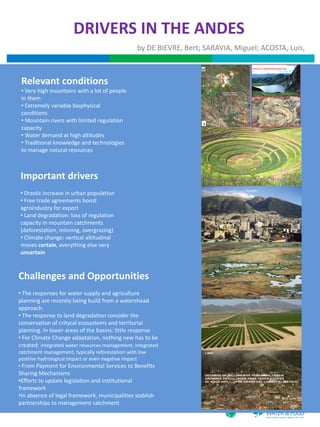
- 1. DRIVERS IN THE ANDES by DE BIEVRE, Bert; SARAVIA, Miguel; ACOSTA, Luis, LAGUNA YANACOCHA UBICACI N (Composit 1999) ANTES DE LAS OPERACIONES MINERAS (1992) Proyecto Proye cto Maqu i Ma qui Yanacocha Norte Relevant conditions # Proyecto Yanacocha Sur Proyecto Proyecto Pr oyecto Cerro Negro Carachugo La Quinua Very high mountains with a lot of people Ubicaci n antigua Laguna Yanacocha in them AHORA (2006) Extremely variable biophysical conditions Mountain rivers with limited regulation N Cajamarca capacity Coordenadas Proyec ci n U TM Datum : Psad 56 Water demand at high altitudes Traditional knowledge and technologies to manage natural resources Important drivers Drastic increase in urban population Free trade agreements boost agroindustry for export Land degradation: loss of regulation capacity in mountain catchments (deforestation, minning, overgrazing) Climate change: vertical altitudinal moves certain, everything else very uncertain Challenges and Opportunities The responses for water supply and agriculture planning are recently being build from a watershead approach. The response to land degradation consider the conservation of critycal ecosystems and territorial planning. In lower areas of the basins: little response For Climate Change adaptation, nothing new has to be created: integrated water resources management, integrated catchment management, typically reforestation with low positive hydrological impact or even negative impact From Payment for Environmental Services to Benefits Sharing Mechanisms Efforts to update legislation and institutional framework In absence of legal framework, municipalities stablish partnerships to management catchment
- 2. !"#$%$%&'()"*&"*&)%+,-./*&01/"2(&3&45%'(5&6/"7./)&(*6&5%2(5&2%*6"8%*)& 0*6/H&I@&7(*&J%%>.*& ! !"#$%"&'()*+(,& -.&./+&"#0%"&"+*+"& & & 9*2/.().)&"*&-+#(*&$%$+5(8%*):&/.;"%*(5&.2%*%#"2)&(*6&25"#(,.& A-.&.K.2,)&%1&,-.).&;5%'(5&6/"7./)&(/.&"*L+.*2.6&(,&,-.&5%2(5&5.7.5&'>& 2-(*;.&(/.&,-.&#("*&6/"7./)&"*&,-.&2/%$<5"7.),%2=&)>),.#)&%1&,-.& ,-.&1%55%B"*;&6>*(#"2)M& !"#$%$%&?()"*&"*&)%+,-./*&01/"2(@&& • A-.&(7("5('"5",>&(*6&.E2".*2>&%1&5%2(5&"*$+,&(*6&%+,$+,&#(/=.,)M&,-")& & ")&(*&"#$%/,(*,&.5.#.*,&"*&2/.(8*;&(*&.*7"/%*#.*,&B-./.&1(/#./)& A-.&;/%B"*;&*+#'./&%1&/+/(5&1(/#./)&/.6+2.)&$./&2($",(&5(*6& 2(*&"*7.),&"*&5%2(5&$/%6+28%*&(*6&'.*.D,&1/%#&/.,+/*)&(,&(&5%2(5& (7("5('"5",>@&C";*"D2(*,&"*7.),#.*,)&(/.&*..6.6&,%&"*2/.().&,-.& #(/=.,@& %7./(55&.E2".*2>&%1&)#(55<)2(5.&1(/#"*;&)>),.#):&"*25+6"*;& • N(/"('5.&$%5"2>&.*7"/%*#.*,)M&,-.).&,.*6&,%&1%2+)&%*&2/%$& "*2/.().6&B(,./<+).&.E2".*2>:&(*6&2/.(,.&#%/.&2%#$.887.& $/%6+28%*&1%/&1%%6&).2+/",>&'+,&5"7.),%2=&#%/.&%O.*&%K./)&'.P./& $/%6+28%*&)>),.#)@&& $(,-B(>)&%+,&%1&$%7./,>@& & • 9*2/.()"*;&*+#'./&%1&B%#.*&1(/#./)M&A-.&"#$(2,)&%1&Q9N&(*6&5('%/< F5"#(,.&7(/"('"5",>&(*6&(/"6",>&2%*8*+.&,%&$%).&)./"%+)& Limpopo Basin Strategic Plan for Reducing Vulnerability to Floods and Droughts. UN-HABITAT/UNEP, July 2007 '().6&#";/(8%*&B-./.&#.*&#";/(,.&,%&+/'(*&(/.()&1%/&B%/=&#.(*)& 2%*),/("*,)&,%&)#(55<)2(5.&$/%6+2./)&(*6&#(>&/.)+5,&"*&5"7.),%2=& 1.2. Human settlements and population ,-(,&,-./.&(/.&#%/.&B%#(*&,(="*;&/.)$%*)"'"5",>&1%/&,-.&1(/#@&A-")& '.2%#"*;&,-.&6%#"*(*,&(;/"2+5,+/(5&(287",>@&&9*&2%*2./,&B",-& /.R+"/.)&*.B&B(>)&"*&B-"2-&)+$$%/,&)>),.#)&(/.&$/%7"6.6&()&B%#(*& The ecosystems of the Limpopo Basin support an estimated 5,200 human settlements. Table 1 shows that 49% and 45% of these settlements are respectively in Mozambique and in South Africa, while the rest are in Botswana and Zimbabwe. ;/%B"*;&$%$+5(8%*):&,-.&6.#(*6&1%/&5"7.),%2=&$/%6+2,)&"*&,-.& Table 1: Number and distribution of human settlements in the Limpopo River Basin per country, including Total Population Distribution of Total Population 1%2+)&%*&6"K./.*,&(;/"2+5,+/(5&)>),.#)&(*6&-(7.&5"#",(8%*)&B",-& /.;"%*&2%*8*+.)&,%&/").:&$/%7"6"*;&(&-+;.&"*2.*87.&1%/&1(/#./)& /.;(/6)&,%&8#.&(7("5('"5",>&(*6&5('%/@& Country No. of settlements settlements (%) (in million) Mozambique 2541 49 1.3 • 9*2/.()"*;&(;.&%1&1(/#./)M&0*&.S%6+)&%1&>%+*;&.6+2(,.6&$.%$5.&1/%#& South Africa 2355 45 10.7 ,%&"*7.),&"*&5"7.),%2=&$/%6+28%*@&F%+*,/".)&"*&C0GF&)-%+56&1%2+)& Botswana Zimbabwe 198 100 4 2 1.0 1.0 %*&)+$$5>"*;&,-."/&%B*&6.#(*6&1%/&5"7.),%2=&$/%6+2,)&(*6&#(=.& Total 5194 Data source: http://earth-info.nga.mil/gns/html/namefiles.htm; and UNDP (2003) 100 14.0 /+/(5&(/.()&#.(*)&,-(,&1%%6&$/%6+28%*&5".)&"*&,-.&-(*6)&%1&(*&(;"*;:& 2.2 +).&%1&,-.&-+;.&#(/=.,&6.#(*6&"*&C%+,-&01/"2(@& Topography and climate Figure 4 shows the geographical distribution patterns of human settlements in the Limpopo River Basin. It can be observed that, firstly, all settlements are close to the river valleys, indicating the !"#$%&'&()*'"+$&,$%"#$-./'&'&$0.1#)$2*3.4$.3$')#3#4%#5$.4$Figure 2.3. !&'&()*'"+$1*).#3$,)&/$*2&1#$influence of the aridity in the Basin which encourages people to settle close to the stream banks. )-/"*="*;&*+#'./&%1&1(/#./)& 67888$/9*939:9$.4$%"#$/&;4%*.4$)#(.&43$&,$<&;%"$=,).>*$%&$%"#$1*3%$,:&&5$':*.43$.4$%"#$?&@*/2.>*4$'*)%$&,$Lastly, human settlements are much denser in Mozambique and South Africa compared with Botswana and Zimbabwe. %"#$>*%>"/#4%39$$!"#$:*3%$ABC$D/$&,$).1#)$3%)#%>"$"*3$#:#1*%.&43$2#:&E$B$/9*939:9$$ Limpopo Basin Strategic Plan for Reducing Vulnerability to Floods and Droughts. UN-HABITAT/UNEP, July 2007 South Africa Livestock Products: Imports $600000000 $500000000 $400000000 $300000000 $200000000 $100000000 $0 1992 1993 1994 1995 1996 1997 1998 1999 2000 2001 2002 2003 2004 2005 2006 SADC World-SADC !"#$%&'()*&+,-)./%)012#3,#4,(15&3,."6+"5"3/.,)3,/(",7)5'#'#,8)9"%, Figure 4: Geographical distribution of human settlements in the Limpopo River Basin :&.)3, Data source: http://earth-info.nga.mil/gns/html/namefiles.htm A(&3$".,)3,&9"%&$",'#'1+&2#3,-"3.)/B,)3,/(",7)5'#'#,:&.)3,4%#5,CDEF,/#,GFFF, $ ;&/&,.#1%*"<,(6'<=="&%/(>)34#?3$&?5)+=$3.=(/5+=3&5"@+".?(/5, Figure 6: Changes in average population density in the Limpopo Basin from 1960 to 2000 ! ;&/&,.#1%*"<,(6'<==HHH?3&?13"'?3"/=-&/&."/.=-&/&+)./?'('I,JKLMNO, 5 Data source: http://www.na.unep.net/datasets/datalist.php3 (UNEP) Figure 2.3 Topography of the Limpopo River basin The Limpopo River Basin has a strong diversity of rural versus urban population. For example, for !"#$ ).1#)$ 2*3.4$ .3$ /*.4:+$ >"*)*>%#).3#5$ 2+$ ,:*%$ &)$ ;45;:*%.4($ ':*.43$ E.%"$ ()*33F$ *45$ 2;3":*459$ !"#$ two countries (Botswana and South Africa) the capital cities and some of the largest urban #G>#'%.&43$ %&$ %"#$ (#4#)*::+$ ,:*%$ :*453>*'#$ *)#$ %"#$ /&;4%*.4&;3$ )#(.&43$ .4$ <&;%"$ =,).>*7$ 3;>"$ *3$ %"#$ population centres reside within the basin boundaries (e.g. Gaborone, Francistown, Pretoria, Polokwane, Thohoyandou, and Witbank). Not reflected in the Basin population figures are other H*%#)2#)(7$ <%)+5'&&)%$ ?&;4%*.43$ *45$ %"#$ I)*D#432#)($ )*4(#$ %"*%$ >&/').3#3$ %"#$ 5.1.5#$ %&$ %"#$ J4D&/*%.$ large urban centres – Johannesburg, Maputo, and Bulawayo, – which are located on the fringes of 0.1#)$.4$%"#$3&;%"F#*3%#)4$'*)%$&,$%"#$>*%>"/#4%9$$ the Limpopo Basin and influence, or are influenced by, socio-economic events and activities within the Basin. Aside from these urban centres the Limpopo Basin is predominantly rural, i.e. !"#$ >:./*%#$ .4$ %"#$ -./'&'&$ 0.1#)$ 2*3.4$ )*4(#3$ ,)&/$ %)&'.>*:$ 5)+$ 3*1*44*"$ *45$ "&%$ 5)+$ 3%#''#$ %&$ >&&:$ approximately 60% of the Basin population lives in rural areas (CGIAR, 2003). %#/'#)*%;)#3$.4$%"#$/&;4%*.4&;3$*)#*39$$!"#$/*.4$(&1#)4.4($,*>%&)$,&)$)*.4,*::$'*%%#)43$.4$%"#$2*3.4$.3$%"#$ /&1#/#4%$&,$%"#$J4%#)%)&'.>*:$K&41#)(#4>#$L&4#$MJ!KLN9$!"#$*1#)*(#$)*.4,*::$&,$%"#$2*3.4$.3$CO8$//$'#)$ 1.3. Rainfall and runoff characteristics *44;/7$)*4(.4($,)&/$688$%&$A7688$//P*7$E".:#$%"#$*1#)*(#$#1*'&)*%.&4$.3$A7QB8$//P*7$)*4(.4($,)&/$R88$ %&$ 67S88$//P*9$ !"#$ *)#*3$ %"*%$ )#>#.1#$ %"#$ ".("#3%$ )*.4,*::$ *)#$ %"#$ /&;4%*.4&;3$ *)#*3$ .4$ <&;%"$ =,).>*7$ The endowment of the Limpopo basin with high levels of biodiversity, as well as a large number of E".:#$ %"#$ :&E#3%$ )*.4,*::$ .3$ ,&;45$ *:&4($ %"#$ -./'&'&$ 0.1#)$ 2#%E##4$ L./2*2E#$ *45$ <&;%"$ =,).>*9$ =$ inhabitants who depend on it, is exposed to highly variable rainfall and runoff conditions which typically occur in the form of droughts and floods. The high variability in rainfall means that the ')#:./.4*)+$>*:>;:*%.&4$&,$>*%>"/#4%$)*.4,*::$"*3$2##4$>&45;>%#5$2*3#5$&4$%"#$>&/'.:#5$)*.4,*::$5*%*$.4$ climatic conditions are difficult to predict, yet floods and droughts are a direct threat to a large %"#$3>&'.4($'"*3#$M3##$Figure 2.4N9$$ proportion of the 14 million human inhabitants in the basin, as well as to the diverse ecosystems. ! Rainfall characteristics Figure 7 illustrates typical variations of rainfall from the annual mean of 334 mm at Beitbridge from Joint Limpopo River Basin Study – Scoping Phase 1934 to 1984. Specifically, it is observed that in the 60 years between 1934 and 1984, only 25 years Final Report – Main Report (i.e., 41 % of the years) had above normal rainfall, while 35 years (i.e, 59 % of the years) had below January 2010 Page 5 (77) normal rainfall. There is also high variability both among years with above normal rainfall and among years with below normal rainfall. This indicates the high likelihood of either floods or droughts in the Limpopo basin. However, the picture becomes complete when looking at the related flow regime of the Limpopo, which is also characterised by high variability (Figure 8). ! 7
- 3. !"#$%#&'()!"" #$%&'$"()*+,)-."/,0'$"1$2)'$*-3."" '45"67,"/%0*8"%9":;5)%<%=,)" &;"(*'4'">27')5*3'4."?')@"#*%)5'4%."'45"/*4@7'3"(%2'40-'+'47"
- 4. Drivers of change in the Blue Nile Basin by Matthew McCartney and Tilahun Amede Water and agriculture are central to economic development and poverty alleviation in Ethiopia. Drivers of change pose great challenges as well as substantial opportunities for dynamic and sustained progress. Current situation In Ethiopia, 35 million people (40% of population) live in acute poverty and 5-‐6 million need food support annually Locally: Rural poor are marginalized small holders Environment/Climate Change Reliant on rainfed agriculture Short of land (farm size, quality and security of access) Increased variability in climate increases vulnerability of the poor Lack access to reliable water supply (and other inputs) Low levels of agricultural productivity Locally: Extremely vulnerable to hydrological variability But significant water resources Farmers choices more difficult (125 Bm3 = 1,400 m3 per capita) Increased vulnerability Nationally: available to contribute to Possible need to change livelihood strategies (e.g. croppers to livestock) Land degradation is excessive (1.9 Bt topsoil lost annually) development Low levels of hydraulic infrastructure Basin average irrigation requirement Low levels of irrigation (640 ha out of potential > 5 million) Nationally: 12,000 1983-‐2012: 8,244 Average annual irrigation 2021-‐2050: 8 ,491 Requirment (m3ha-‐1) 11,000 2071-‐2100: 9 ,726 Hydrological variability costs economy 1/3 growth Considerable uncertainty about the impacts of CC 10,000 9,000 Area suitable for rainfed agriculture may decline 8,000 Adaptation strategies are essential 7,000 6,000 Investment in water infrastructure (e.g. storage) critical 1980 2000 2020 2040 2060 2080 2100 Simulated change in irrigation water requirement in the Blue Nile Basin under a mid-‐range climate scenario (A1B) (1983-‐2100) Demographic/Societal Population growth in Ethiopia is 3.2% per year Locally: More mouths to feed Increased fragmentation of land Expansion to increasingly marginal land Political/Institutional/Legal More competition for scarce water and other natural resources Impedes the economic well being of households Ethiopia Population Since 1988, gradual shift from controlled to more market-‐oriented economy 180 Population (millions) Nationally: 160 140 Locally: Agricultural land is overcrowded and over-cultivated 120 Considerable changes in prices of foods and consumer goods 100 Health infrastructure is not keeping pace with pop. growth 80 Increased opportunities for off-farm activities Current population 90 million Energy demand is growing rapidly 60 40 Land ownership vested entirely in the state; security of tenure unclear Economic and social indicators are declining 1980 2000 2020 2040 2060 2080 2100 2120 Uptake of technologies and practices affected by tenure Forecast Nationally: Ethiopian state is dominating force in defining access, distribution and tenure of land Internal market liberalization and devaluation of currency 10 years of negotiation have, so far, failed to deliver a comprehensive agreement on managing Nile water (Egypt and Sudan yet to sign Nile pact) Unilateral development of upstream water resources (e.g. Renaissance Dam) Considerable uncertainty about future political direction Economic/Trade (Globalization) Ethiopia is increasingly interlinked to the rest of the World Comparison of foreign & domestic Locally: ag investment in Oromia State Increased demand for agricultural products Technological Innovations Employment opportunities Area (ha) Projects Disproportionately benefits those with assets Domestic 149,148 2,750 Benefits greatest in areas with infrastructure/communications Foreign 1,444,308 1,001 Risk of increased marginalization of the poor The Information and communications revolution in Africa boosts growth Voice coverage gaps in Ethiopia Nationally: Locally: Greater opportunity for economic growth Increasing access to telecommunications 5% 10% Ethiopia commodity exchange facilitates food trade and agricultural investment Better informed farmers are able to make better choices Niche overseas markets (e.g. for teff/coffee/flowers) Need to ensure information tailored to farmers needs Higher risks associated with fluctuations in global financial systems 85% Risk of domestic markets being flooded with world market commodities Foreign Direct Investment in land (and water) Nationally: Existing coverage Efficient market gap Coverage gap Voice services expanding rapidly but internet more slowly In Ethiopia on ly one provider so no competition and prices still relatively high
- 5. !"#$%&'%()*&+,)-.,(& !"#$%&'(')*+%,*-#%./01023#+%4#52678'/'99#%:#2*)+%% ;0<0=>2#%;?52)02$#+%78'/'99#%,#@@8'%52$%4#22'#%A5"*2% % 7#&,)894%(:);+&'(+4 ;(%(+:&,#,%4 >/++(,%)0.,"&%&.,4) <#4&,)8$(0&1&0) 5(#+,&,-)6+.0(44(4 &,)%?()@.*%#)<#4&,) =(4$.,4(4 :7*#'8", AB%(+,#*) 3,%(+,#* 9'02,<-", ;'&*'5*7*81 C./%4&"()D#4&,E C&,4&"()D#4&,E :)'0%" 7#+F(%4 !"#$%&'()*+, (&"--.&" 6.*&0&(4 =*%&'8*$0 9'02, (&"--.&" 3,4%&%/%&.,4 !"#$%&'()*(#+,&,-) /0"&%1, #,")&,%+."/0%&.,) 2"#'02- 3&'0-45$.02'&1 .1).,2-+./," 3,1.+:#%&., '%&""#"08-, 3,%(+'(,%&.,4 3&'0-4 5$.02'&1 G(0?,.*.-9 >"%*$0'7, 6$7*8*+'74 ?08"%&'8*$0 /+$0$#*+, =(4./+0(4 >"-$.&+", ='0'%"#"08 !D.'()"(%(+:&,#,%4).$(+#%()#%) A,?#,0(4)0.$&,-)#,") '#+&./4)40#*(4H)*.0#*I)+(-&.,#*)#,")D#4&,)*('(* #"#$%&'():(0?#,&4:4) %?#%)+("/0(4)<#4&,2*('(*)4%+(44(4) #,")&:$+.'(4)+(4&*&(,0( !"#$%&'($&)*#$+,-#)"*&".&.,-#"+/&)*&#($&/0/#$1&)/&*"*23)*$,+&,*4& 1,)*30&)*.35$*-$4&60&#($&4"1)*,*#&.,-#"+&,#&,&7)8$*&#)1$& !"#$%&'%()!%$*+,$&)-+"&") '%()*/(0.1)21&3,)-.,(& 1. Climate variability 2. Demographic pressure 3. Land pressure 4. Increasing energy demands 5. Trans-boundary issues 6. Political-Economic conditions
- 6. !"#$%&'()'$()$*+,+-$./01'"/2$34#)&0(/'$ %5$6"&07/8#$9&:$;$3(</)$6//1$ ."&=$('$H:=:0#$34#)&0(/$!"()1()>$IH3!JK$ 3/<#$#R4#02='$B0/<$$ • 34#)&0(/$="()1()>$('$&$!"#$"%&"'(!)*(+,-!) /:0$'4#)&0(/'$ -.)"*/0"'"'0)%-##"1&().2+23(#)?5$ 45678) (@#)AB5()>$&)@$4/<?()()>$1)/C)$=0#)@'$ Y6/)A):#@$>7/?&7$@#20#''(/)$"(='$)&A/)&7$#4/)/<(#'$()$="#$0#>(/)$C"/$ "&F#$?#4/<#$@#2#)@#)=$/)$<()#0&7'$&)@$/VQB&0<$()4/<#^S_:0&7$&0#&'$ &)@$:)4#0=&()A#') ?#4/<#$()40#&'()>75$'#2&0&=#@$B0/<$:0?&)$&0#&'S$`0?&)$:)#<27/5<#)=$ 0#<&()'$'=:??/0)75$"(>"O$5#=$<(>0&A/)$4/)A):#'$=/$:0?&)$&0#&'O$7#&@()>$=/$ – 6&2=:0#'$#7#<#)='$="&=$4&))/=$?#$</@#7#@$ @('&V#4A/)$&)@$2/7(A4&7$:)0#'=S$X&E/0$:2"#&F&7'$()$)&A/)&7$2/7(A4'$B/77/CO$ 4/:27#@$C(="$2/7&0(a&A/)$0#>(/)&775$="&=$7#&@'$=/$4/)b(4=$?#=C##)$ 2/7(A4(&)'$c<&)5$2/2:7('=d$C"/$'C()>$"&0@$=/$#(="#0$7#e$/0$0(>"=S$HNDO$="#$ – D)47:@#'$':?E#4AF#$()=#020#=&A/)'$ <&()'=&5$/B$#4/)/<(4$>0/C="$('$0#@:4#@S$W22/0=:)(A#'$B/0$="#$>0##)$ #4/)/<5$&0#$B0/a#)$()=#0)&A/)&775$&)@$C(="()$4/:)=05SSS$C"(4"$7#&@'$=/$ – 60#&=#'$4/<2#77()>$)&00&AF#'$ &?:'#'$&)@$0('1'$=/$="#$#)F(0/)<#)=$&)@$="#$0:0&7$2//0$C"/$@#2#)@$/)$(=SSS$ 3#F#0#$47(<&=#$4"&)>#$(<2&4='$)(4"#$20/@:4A/)$&0#&'O$&)@$0:0&7$ – G0#F#)='$5/:$B0/<$?#()>$?7()@'(@#@$ '=&1#"/7@#0'$C"/$&0#$@#2#)@#)=$/)$="#'#$&0#$:)&?7#$=/$&@&2=^Z$ !"#$%&'#"()%*+(,%(*,-+".#/% Y$ 9:;<=<=) H3!$('$#''#)A&775$&$'=:@5$/B$/:0$ Y^D)@:'=0(&7(a&A/)$&)@$2/2:7&A/)$>0/C="$7#&@$=/$&)$()40#&'#$()$@#<&)@$ B/0$B//@O$()47:@()>$<#&=$&)@$()40#&'()>$7&)@$'4&04(=5S$X&01#=$/22/0=:)(A#'$ B/0$7(F#'=/41$20/@:4='$4/)A):#$=/$()40#&'#$&=$7/4&7O$0#>(/)&7$&)@$ 4/77#4AF#$(>)/0&)4#$&)@$&$20/4#''$/B$ ()=#0)&A/)&7$7#F#7^D)(A&7$()F#'=<#)='$()$<#4"&)(a&A/)$&0#$<&@#$B0/<$ 20/f='$B0/<$7(F#'=/41S$!"#$4"&)>#'$&0#$':22/0=#@$?5$&$2/7(A4&7$20/4#''$ Z$ ="&=$="&=$?0()>'$()$7&)@$0#B/0<$="&=$>(F#'$7&)@$=/$'<&77Q'4&7#$B&0<#0'O$ =/>#="#0$C(="$()B0&'=0:4=:0#$@#F#7/2<#)=$=/$(<20/F#$7()1'$=/$ 4/77#4AF#$7#&0)()>$ <&01#=S$g4/)/<(4$>0/C="$&)@$<&01#=$@#F#7/2<#)=$('$B:0="#0#@$?5$ ()40#&'()>$3LN6$()=#>0&A/)^Z$0.1,23%!#"%456%7#)(%+-8%9.$6%2,((%!#"%:#;<$ !"#$%&=#(.>?,%(*,-+".#/% ;7>=5?) ./01'"/2$3#=:2$ YG/C#0$@#<&)@'$()$!"&(7&)@$&)@$h(#=)&<$7#&@$=/$&$'"&02$()40#&'#$()$ "5@0/2/C#0$@#F#7/2<#)=S$!"#$@&<'$&0#$)/=$f'"QB0(#)@75O$0#':7A)>$()$="#$ /?7(=#0&A/)$/B$@/C)'=0#&<$f'"#0(#'S$.(@#'20#&@$20(F&=#$'#4=/0$ L=$&$'<&77$M7/?&7$N0(F#0'$C/01'"/2$C(="$</'=75$%HG$()F(=##'O$6"&07/8#$9&:$&)@$ 4/02/0&Aa&A/)$/B$f'"$B&0<()>$/44:0'S$9/4&7$B&0<#0'i$&)@$f'"#0'i$ L<&)@&$P&0@()>$7#@$&$'=#2Q?5Q'=#2$'4#)&0(/$="()1()>$#R#04('#S$!"#$C/01'"/2$ 7(F#7("//@'$4"&)>#O$C(="$0#<(8&)4#'$&)@$<(>0&A/)$B&4=/0()>$()$ '=0/)>75^S63W'$?#>()$=/$#)>&>#$C(="$@#4('(/)Q<&1#0'$&)@$&@F/4&=#$B/0$ 2&0A4(2&)='$C#0#$'27(=$:2$()=/$=#&<'$/B$=C/O$0#20#'#)A)>$,$/B$="#$T$?&'()'S$!"#$ 4"&)>#S$6/00:2A/)$'150/41#='^S!"#$):=0(A/)&7$)##@'$/B$'/4(#=5$&0#$/B$ >0/:2'$C#0#$>(F#)$&?/:=$US,$"/:0'$=/$>/$="0/:>"$="#$#R#04('#O$C(="$#&4"$=#&<$ >0#&=$4/)4#0)O$&'$7#''$f'"$<#&)$7#''$20/=#()$&F&(7&?7#$B/0$="#$2//0S$ P/C#F#0O$&'$="('$@/#'$)/=$'##<$=/$<&8#0$=/$()F#'=/0'O$'=&1#"/7@#0'$ 4/<()>$:2$C(="$*QU$@(V#0#)=$2/''(?7#$B:=:0#$'4#)&0(/'S$3/<#$/B$="#'#$'4#)&0(/'$ #F#)=:&775$@#4(@#$=/$':00#)@#0$="#$f>"=SZ$ C#0#$'"&0#@$&=$="#$#)@O$&)@$B##@?&41$C&'$>(F#)S$$ !"#$%&(*,-+".#%@A%(B"",-8,"/% $ 5:97) H3!-$W:0$X#="/@/7/>5$ YD)$="#$4/)=#R=$/B$0#>(/)&7$2/C#0$(<?&7&)4#'O$&)@$&>&()'=$&$?&41@0/2$/B$ >7/?&7$#4/)/<(4$:)4#0=&()=5O$HND$@0(F#)$?5$'#7BQ()=#0#'=$7#&@'$=/$2//0$ @/<#'A4$#4/)/<(4$@#F#7/2<#)=O$4"&0&4=#0(a#@$?5$()#j:(=5$&)@$7&)@$ >0&??()>S$H//@$&)@$B#0A7(a#0$20(4#'$0('#O$&)@$&$k(7#$2&4=$('$B&0$&C&5S$!"#$ ."(7#$="#0#$&0#$<&)5$@(V#0#)=$C&5'$/B$#R#4:A)>$&$'4#)&0(/$="()1()>$#R#04('#$ 4/:)=05$'=0(F#'$B/0$C&=#0$'#4:0(=5$()$&$@#'2#0&=#$&8#<2=$=/$1##2$4/)=0/7$ I#S>SO$="#$2/2:7&0$Y40/''()>$/B$:)4#0=&()A#'ZJO$C#$@#4(@#@$=/$#R2#0(<#)=$C(="$&$ /B$="('$()40#&'()>75$'4&04#$0#'/:04#S$$N/<#'A4$2/7(A4&7$()'=&?(7(=5$('$/)#$ </0#$>7/?&7$&220/&4"$="&=$C/:7@$&77/C$B/0$F&'=75$@(V#0#)=$'4#)&0(/'O$#&4"$ l0#'2/)'#iS$$!"#0#$('$)/$#V#4AF#0#'2/)'(?7#$>/F#0)&)4#O$&)@$C&=#0$ 4/<2#AA/)$&)@$'4&04(=5$()40#&'#O$B/0$@(V#0#)=$:'#0'$:2Q$&)@$ =&1()>$()=/$&44/:)=$@(V#0#)=$'=&1#"/7@#0'O$=0#)@'O$:)4#0=&()A#'O$&)@$C(7@4&0@' @/C)'=0#&<S$H&0<#0'$4&))/=$&@&2=$=/$="#'#$'"/0=&>#'O$&)@$ [&)@/0$C#(>"A)>$="#'#$B&4=/0'$@(V#0#)=75S$ @#B/0#'=&A/)$&)@$7&)@$@#>0&@&A/)$C/0'#)S$!"#$0#':7=$('$/)#$/B$()40#&'#@$ 2/F#0=5$&)@$()#j:&7(=5O$&)@$2//0$&@&2=&A/)$=/$()40#&'#@$47(<&=#$'"/41'SZ$ $$ !"#$%&-+""+>?,%CA%'#"()%*+(,%(*,-+".#/%% .#$>&F#$#&4"$=#&<$2&2#0$C/01'"##='$&)@$&$GG!$C(="$@(0#4A/)'O$&'$C#77$&'$ 2&2#0$0#4=&)>7#'$I=0#)@'J$&)@$4(047#'$I:)4#0=&()A#'C(7@4&0@'JO$&77$4/7/0Q4/@#@$ @=9A4) I?7:#$]$2/7(A4&7()'A=:A/)&7O$>0##)$]$#)F(0/)<#)=&7O$5#77/C$]$#4/)/<(4O$/0&)>#$ H/77/C()>$&$2#0(/@$/B$()'=&?(7(=5O$4(F(7$'/4(#=5$&)@$5/:="$</?(7('#'$=/$?0()>$ ]$@#</>0&2"(4'/4(&7O$2()1$]$=#4")/7/>(4&7JS$3"/:7@$C#$@/$="('$#R#04('#$&>&()O$ &?/:=$@#</40&A4$0#20#'#)=&A/)&7$>/F#0)<#)=O$'##()>$&$'"(e$()$0#>(/)&7$ &)@$B/0#(>)$()F#'=<#)=$2&8#0)'$&'$C#77$&'$(<20/F#@$#j:(=&?7#$%&'()$ C#$C/:7@$&7'/$()47:@#$&$=0(&)>7#$'"&2#$B/0$'=&1#"/7@#0'S$L=$="#$#)@O$="#$=#&<'$ 0#>:7&=/05$B0&<#C/01'$&)@$0#'/:04#@$4//0@()&A/)$&)@$4/)b(4=$ C#0#$()'=0:4=#@$=/$4/<?()#$@(V#0#)=$'"&2#'$&)@$4/7/0'$=/$40#&=#$4/>#)=$ 0#'/7:A/)$'=0:4=:0#'S$3<&77$"/7@#0'$()$0:0&7$&0#&'$</?(7('#$="#<'#7F#'O$ )&00&AF#'$/B$@(V#0#)=$2/=#)A&7$B:=:0#'S$ (<20/F#$20/@:4AF(=5$&)@$="#(0$()4/<#'$'##()>$7#''$(<2#0&AF#$B/0$:0?&)$ <(>0&A/)S$ $ !"#$%&",D.$,%*E+-D,6%",(.2.,-)%*#$$B-.>,(/% F#"%$#",%.-!#"$+>#-%+G#B)%)E,(,%-+""+>?,(6%=2,+(,%=.*1% B=%)E,%*E+")%#!%.8,->H,8%)",-8(IB-*,")+.->,(%+-8%)E,% =".-)J#B)%#!%)E,%!B22%(*,-+".#(<%
- 7. !"#$%&'#()*$+,*-(".(&/'01,( 23(4$5"0(6""7('0)(6/'*#"8,(9':;(<$=/(&"0=*$2:%"0-(.*"5(9":$-(9,2,#('0)(>":1(?,**,3( @,,)(."*(A"#$%&'#(&/'01,( !"#$%&-('0)($0-%=:%"0-( B#"2'#(,&"-3-=,5-(&'0(-:AA"*=('(A"A:#'%"0(".(C(2$##$"0D$.( !"#$%&'#()*$+,*-('*,(-,=-(".($0-%=:%"0-;($0=,*,-=-;()$-&":*-,-( A,"A#,(( '0)(A"#$&3(A*"&,--,-( 'E F5A*"+,(<'=,*(A*"):&%+$=3G((H'=,*(A*"):&%+$=3("+,*(5"-=( • !"#$%&$'"#('*,(*:#,-(N#'<-;(&:-="5-;(*,1:#'%"0-E( '*,'-($-('(.*'&%"0(".($=-(A"=,0%'#;((I/$-(*,J:$*,-(#"01K=,*5( • !"%)*)#%#(:0),*#$,(A"-$%"0-('0)(*,O,&=(0,,)-;(<'0=-;(.,'*-( $0+,-=5,0=(( '0)(+'#:,-( 2E 4/'*,(*,-":*&,-('0)(*$-7-(5"*,(,L,&%+,#3G(M$+,*(2'-$0-( • +,#-'&*#)#('*,(&"0&,A=-('0)($),'-(=/'=(.*'5,('0'#3-$-;( -:AA"*=(5'03()$L,*,0=(A,"A#,(=/*":1/(-/'*,)(,&"-3-=,5( ),2'=,-('0)(A,*&,A%"0-( 1"")-('0)(-,*+$&,-((( • .'/,-0(1*'-)##)#($0&#:),(&"52$0'%"0-(".('2"+,('0)(A:2#$&( A"#$&3('0)(')5$0$-=*'%+,(-3-=,5-( 9":$-(9,2,#( 6"##'2"*'%+,(A"#$%&-R('(*,'#$=3S(( 4"&$'#(,01$0,,*$01("*(Y2*$&"#'1,VS( TI/,(53=/(".(:0$+,*-'#(-,#U-/0,--(,0):*,-($0(A'*=(2,&':-,($=V-( I/,(A*"&,--(".(-"&$"K=,&/0$&'#($00"+'%"0($-('(5,--3()"K$=K 0"=(,0%*,#3(<*"01(W("0#3(5"-=#3(-"XG(:)"E/)*F(GHIIG( 3":*-,#.(!"#$%&'()(A*"&,--G(@,$=/,*(*,-,'*&/,*-(0"*(A"#$%&$'0-( ( &'0(),=,*5$0,(=/,()$*,&%"0("*(A'&,(".(&/'01,G(P:=(<$=/('( “In experiments testing collaborative behaviour, 50% of par ticipants systematicall y and pr edicta bl y behave ),,A,*(:0),*-='0)$01(".(=/,($0-%=:%"0'#(#'0)-&'A,('0)(-"&$'#( cooperatively. Some do so conditionally: they treat kindness with A*"&,--,-;(*,-,'*&/,*-('0)(A"#$%&$'0-(&'0(-:AA"*=(A,"A#,(="( kindness and meanness with meanness. Others cooperate unconditionally- even when it comes at personal cost.“ $5A*"+,(=/,$*(#$+,#$/"")-('0)(<,##K2,$01G( ( >":1(?,**,3;(Z[( 4"5,%5,-(=/$01-(1"(<*"01( 23''45(6)789,'&*#( 2.'/,$-8/(6)789,'&*5( 2:845(6)789,'&*#( ;*8"#18*)"-0( 6"5A*"5$-,( C18-,%0( <'//86'*8$'"( 6"0-%=:,0&3(K2:$#)$01( =)/D@,"%)*)#%( =78*,">( P*$075'0-/$A( +)-),%( ;*&#%( Q"*-,K=*')$01( =7'*%@%)*A,#A( ?'">@%)*A,#A( ( !>"'*8"-)( <'A1*)7)"#,'"(( ( !**)#1'"#,6,/%0( B)#1'"#,6,/,%0(
- 8.
- 9. !"#$%&'&()#*'+,%%&-*.&%+ /0+1)2&%+3&&4+5+3$*6'&7"+8*9+ #$%&'()(*+%,)"+''(-,.('"&,/"0&$"1(2$3"0("%(41)$0$)5"03,'/6(34"/(%+$.$/!"$7*7" 4$%&,'+8,.('!"0&$"93$$'":$-();.('!"0&$"+'0$3'$07"#&,0"/,+<!"+0"4,5"=$"0&$"4(/0"<+>%;)0" (6"(;3"?<3+-$3"051$/@"0("4(<$)"(3"13$<+%07"#&+/"A;/0"&+*&)+*&0/"0&$"'$$<"0("%('/+<$3"+0"+'" (0&$3!")$//"B;,'.0,.-$"2,5/7"C("&(2"<($/"0$%&'()(*5"+'0$31),5"2+0&"(0&$3"<3+-$3"051$/!" ,'<"&(2",'<"2&$'"<($/",'"+''(-,.('"=$%(4$"+41,%D;)E"#&3$$"F$5"B;$/.('/G" 1 ++++++++,:+;"#$%&'&()#*'+)%%&-*.&%+!"#$%&'#( &23456789::;<3=;:>8 M1""CA+=);$+AF"#)?#+;&'"6*%#"A+ )%(&""'#<+%"=+>?@"AB+=)''+/"+:&9%C+:&6D+ MT"=<+/"7"6+6)A4+2*%*("2"%;+F6&(6*2AE + )%A;692"%;A+ • 3')2*;"+#$*%("D+$"*;E#&'C+A;6"AA<+ MU*6)"."A+=);$+$)($"6+0)"'CAV++ =*;"6'&(()%(EC6&9($;<+F"A;A+5+C)A"*A"A+ MT"=+2";$&CA+&:+A;&6*("E;6*%AF&6;+;&+ F6"-"%;+F&A;MF6&C9#.&%+'&AA"AV+ • G)A)%(+F&F9'*.&%A+ MT"=+;0F"A+&:+#$"*F+/)6;$+#&%;6&'+ + MT"=+/"%"?;MA$*6)%(+2"#$*%)2A+ • H*;"6+A$&6;*("E#&%I)#;A+ MT"=+"%"6(0+A&96#"A+K=)'C#*6CANLV+ • J%"6(0E:9"'+%""CA+K#'"*%"6<+%&;+C"F'".%(L+ MY6""%+;"#$%&'&()"A+ 2 ++++++++,:+;"#$%&'&()#*'+)%%&-*.&%+*+,-'#( MG*)%=*;"6+$*6-"A.%(V++ MY6*)%+A;&6*("V++ +$%&(".,#/&0()1,&0#!"$&=+#*%+#966"%;+ MH"*;$"6+:&6"#*A;A+*%C+2*64";+)%:&62*.&%++ -)*+#"''+F$&%"A+*%C+)%;"6%";+K,3!AL+ >$)($MF&;"%.*'B+F6&C9#;A+;6*%A:&62+;$"+ M1&'*6<+=)%C<+/)&:9"'+"%"6()"A+ :9;96"N+ MW)#6&?%*%#"<+33!A<+#6&F+)%A96*%#"+ • H$"%+;$"+A&'9.&%A+*'6"*C0+"@)A;<+=$*;+ !"#$%&'(+K#&%%"#;"C+=);$+C6)-"6ALD+ A;*%CA+)%+;$"+=*0+&:+2*AA+*C&F.&%N++ + • &)#*D+8*#4+&:+2&%"0E6"A&96#"A+K&6+2*64";+ • O&=+#*%+="+C"-"'&F+%"=<+)%%&-*.-"+=*0A+ )%;"6"A;LV+U*'9"AE"@;"6%*')."A+%&;+#*F;96"C+ ;&+9A"+&'CE"@)A.%(+;"#$%&'&()"AN+H$0+ !#%+,-*(.-.D+8*#4+&:+F&')#0+)%#"%.-"A+K&6+ $*-"%P;+;$"A"+;$)%(A+/""%+9A"C+)%+;$)A+=*0<+ "@)A;"%#"+&:+2*'*C*F.-"+&%"AL+ /":&6"N+ • /&'#0,(#)D+39';96*'+6"A;6)#.&%AE/"')":AV+ • ,A+2*AA+*C&F.&%+&:+>&%"MA)Q"M?;AM2&A;B+ W0&F)*V+8*#4+&:+4%&='"C("+ A&'9.&%A+%"#"AA*6)'0+/"7"6+;$*%+'&;A+&:+ • &*1-"#*D+3$*%("+&##966)%(+;&&+X9)#4'0E '&#*''0+AF"#)?#+A&'9.&%A+;$*;+#*%P;+A#*'"+9FN+ 9%#"6;*)%+ 3++++,:+;"#$%&'&()#*'+)%%&-*.&%+,#(+&$!"',2)3*-"(*+)( )!3%!53/6"<+*%C+;$"6"+*6"+)%"-);*/'0+#$*%("A+ ;$*;+="+#*%%&;+F6"C)#;<+=$*;+)A+;$"+3RHSPA+6&'"N+
- 10. !""#$%&'()*+(!',!!&-+./01)+2032#-( 43#%5$(6,""32)(6$.)+7()3($3,2(81.%&( *9"://;;;<"3#%5$.,""32)<32'/#%&=./;1)+2;32#-( >12=(>,##%'1&?@(!2&3,)(A1&(63+.8+2'+&?( B%&' .(C3##+'+(D3&-3&<(C3&)15):(712=<7,##%'1&E=5#<15<,=( ( !F-6+GG?( !',!!&-+.(H01)+2032#-(;*+&(,.+-(3,).%-+()*+(!&-+.K(%.(1(;+8(81.+-(43#%5$(6,""32)(6$.)+7(H466K(-+.%'&+-(J32(1""#%51L3&(HI&E%$F#K(N/#"E(1)()*+(#351#()3(%&)+2&1L3&1#(.51#+(J32($*I&H$E-*& -*&%K#&.("N/(J32(,&-+2.)1&-%&'()*+(H$E#N-*#&/-E%"-H)J(*&(P&.$%#"(1&-()*+(%7"15)(3J(N$*/&)E#S&N$*/&O$*$L#O#*%&$*/&'N-O$%#&'K$*L#(,"3&(%)<((R*+(.$.)+7(2+S,%2+.(*,&-2+-.(3J(71".(1.( %&",)(8,)()*+.+(12+("23A%-+-('#381##$(1)(?=7(1&-(?(*+5)12+(."1L1#(2+.3#,L3&@(7+1&%&'()*+(.$.)+7(51&(8+(1""#%+-(%&(N#EE&%K$*&4T&O-*)%#E<((UJ(.)1=+*3#-+2.(*1A+(8+9+2(#351#(-1)1()*+.+(51&(8+( ,.+-<(01)+2032#-(.,""32).(%&J327+-("3#%5$(1&-(-+5%.%3&(71=%&'(123,&-(;1)+2(1&-(%.(8+%&'(J,2)*+2(-+A+#3"+-(1.(1(&+'3L1L3&(.,""32)(.$.)+7(H[66K(%&("23]+5)(@U6<( !"#$%#& $''()*%+& H-+I&+( ,.+2&17+( 1&-( "1..;32-@( 0123& 7+& X+.,#).:( 71".<( ( !55+..( )3( ."1L1#( 2+.,#).( 829:;9<02&>+&6*3;(2+.,#).(J32(12+1.(3J(%&)+2+.)( C0@82&!@02+&U7"15)(3J(53&A+2.%3&()3(1(."+5%I5(523"( ;1%)(J32(+71%#@(5#%5=(;%)*%&(1(J+;(7%&,)+.K(32(#3'%&( J32( -3;-( %&( 1( 21&'+( 3J( '2%-( J3271).( HJ32( H2%5+K(;*+2+(.,%)18%#%)$(%.(*%'*( 1.( ',+.)( H8,)( )*+&( &3( 53&L&,%)$( J237( .+..%3&( )3( J,2)*+2(1&1#$.%.K@('+3823;.+(H3&#%&+(A%.,1#%.1L3&K@( .+..%3&K<((C*+5=(%&(."17(J3#-+2(%J(+71%#(&3)(2+5+%A+-( .,7712$(32(1&1#$.%.( 1"##&'(D#"&/#'"#$E#E& -*&$"#$E&%$F#*&)G&HI& "-'#& 829:;9<02& ?+& !&1#$.+<( ( !&1#$.+( )*+( 2+#1L3&.*%".(8+);++&(71""+-(A12%18#+.<( 829:;9<02& 4+& Y%+;( )*+( -1)1<( ( C*1&'+( 53#3,2( .51#+.<( ( Y%+;( %&( F33'#+( >1"./Z12)*<( 43"( 3,)( J32( ,$-*&.-*/(.+&>1"(.*3;.(#351L3&(3J($3,2(5,22+&)( 537"12%.3&(;%)*(3)*+2(71".<( .%7,#1L3&<( 6+A+&( .)+".( )3( ,.%&'( )*+( .$.)+7<( ( M%2.)( ;+(2,&(1(81.+#%&+(H5,22+&)(.)1)+(3J(.$.)+7K()*+&(1&( 1#)+2&1LA+( H!"#"$ #1&-( ,.+( 5*1&'+@( 5#%71)+( 5*1&'+K<( D%&=()3(J,##(-35,7+&)1L3&(1&-(*+#"(.$.)+7<( !;93+& U7"15)( 3J( .5+&12%3( 3&( )2++( 53A+2<( ( [3;( 2,&( )*+( 0123& =+& X+.,#).:( .)1).<( ( !55+..( )3( L7+( .+2%+.( .5+&12%3(.%7,#1L3&<( 2+.,#).( J32( -3;-( ( HZP5+#K@( 1&-( 3&#%&+( 2D$G(%"$*EG-"$J(*& /#'"#$E#E&-*&'K$*L#/&$"#$& M(L&-*G)%E&/#'"#$E#&H)%&*(%& #D#"I.K#"#&-*&'K$*L#/&$"#$& 9D#"$NN&.$%#"&H$N$*'#& /#'"#$E#E&H)%&*(%& A%.,1#%.1L3&<( #D#"I.K#"#&-*&'K$*L#/& 829:;9<02&5+&Y%+;(8$(12+1(H!"#"(1-7%&%.)21LA+( $"#$& 2+'%3&.K(%&.)+1-(3J(8$("%P+#<( 0123&4+&N+I&+()*+(12+1(J32()*+(1&1#$.%.(H5,22+&)#$( ?G(-+'2++(L#+.(E(?=7(2+.3#,L3&(1&-(?(-+'2++(L#+.( E(?(O1<(2+.3#,L3&K<(>3A+(71"(,&L#()*+(L#+()*1)( $3,(;1&)(%.(*%'*#%'*)+-(H,.+()*+(.++(L#+-(?=7(1&-( .++(L#+-(?O1(83P+.()3(Q337(%&(1&-(3,)K<(4%&=(L#+.( 12+(?(*+5)12+(2+.3#,L3&@(8#,+(L#+.(12+(?=7( !;93+(X+.,#).(*1A+(&+;(%53&(J32(537"12%.3&(;%)*(81.+#%&+( 2+.3#,L3&<((R*+&('%A+($3,2(2,&(1(&17+(1&-(5*33.+( )*+(2+S,%2+-(2+.3#,L3&(J237()*+(-23"-3;&(7+&,<( 0123&>+&X+.,#).:(&1221LA+<( (!(;2%9+&(.,7712$(3J( )*+(.%7,#1L3&(2+.,#).( 829:;9<02&6+&U&)+223'1)+(71"(A1#,+.(J32(1("3%&)<( 0O$NN&-OG$'%&(*& E#$E(*$N&.$%#"& H$N$*'#&(*& $D#"$L#&(D#"&JN#& !;93+&6"1L1#(%7"15).( 0123&5+&42+"12+(-1)1<( (F1)*+2.(1&-("235+..+.(1##(3J( :@!A&19&0123&B+&43#%5$(+P+25%.+.<(!""#$(1(.5+&12%3( 1K#&$GGN-'$J(*&(P&%K#&E'#*$"-(&N#/&%(QR& )*+( -1)1( )*1)( ( $3,( &++-( J32( )*+( 81.+#%&+( 2,&( 1&-( 829:;9<02&B+&Y%+;(%&(F33'#+(Z12)*<( J32(#1&-(,.+(32(5#%71)+(5*1&'+<( 53"%+.( %)( )3( $3,2( ;32=."15+( 3&( )*+( .+2A+2.<( ( R*+( .$.)+7(71$(&++-()3(8,%#-()*+(2+S,%2+-(L#+.(I2.)<( !;93+&6+1.3&1#(%7"15).( !;93+([1221LA+( 01)+2032#-(%.(8+%&'(,.+-(8$(1(21&'+(3J( 829:;9<02& 7+& N+I&+( "3%&).( 3J( %&)+2+.)<( R$"+( C0@82& !@02+& U7"15)( 3J( 53&A+2.%3&( 3J( J32+.)( )3( ,.+2.(J237(-+A+#3"7+&)(81&=.@()*23,'*( 5332-%&1)+.(HNNK(%&-%A%-,1##$(32("1.)+(1.(#%.)<( "1.),2+(%&(!DD("23)+5)+-(12+1.( 0123&6+&6)12)(.%7,#1L3&<((R1=+.(183,)(T(7%&,)+.()3( ^U[F_`.()3(&1L3&1#(1&-(#351#('3A+2&7+&)@( 2,&(.3"*%.L51)+-(*$-23#3'%51#(81.+#%&+<((UJ(L#+(&+A+2( ,&%A+2.%L+.(1&-()*+(CFU!X(1.(;+##(1.(1( 8++&(2,&(8+J32+(8$(1&$3&+(+#.+(51&()1=+(T(*3,2.( 21&'+(3J(#351#(.)1=+*3#-+2.(%&(81.%&.<( H8+51,.+(3J("2+V"235+..%&'K(8,)(3&5+(.)12)+-( 823;.+2(;%&-3;(51&(8+(5#3.+-(32(#351#(537",)+2( ( 51&(8+(.;%)5*+-(3W<(0%##(537"#+)+(;%)*3,)(,.+2( 6++(;;;<"3#%5$.,""32)<32'()3(1221&'+( %&)+215L3&<((UJ(#3&'(.%7,#1L3&()*+&(.$.)+7(.+&-.( )21%&%&'( +71%#()3($3,(;*+&(-3&+<( 829:;9<02& =+& N+I&+( Q3&+.( 3J( %&)+2+.)<( C0@82& !@02+& U7"15)( 3J( 53&A+2.%3&( 3J( J32+.)( )3( !5532-%&'()3(2,#+(."+5%I+-(J32(71"( "1.),2+(%&(1(."+5%I5("23)+5)+-((