Jual GPS Geodetic Horizon Kronos 200 RTK L1L2L5 Call Budi 082119953499

HUBUNGI KAMI : PT.MINDS INDO SURVEY, DISTRIBUTOR ALAT UKUR SURVEY DAN PEMETAAN, KOMP/RUKO. MEGA KALIMALANG KAV. 8 JLN KH NOER ALI NO. 11,PEKAYON JAYA BEKASI, TLP : 02195099644/ HP : 082119953499 / 087886144398 PIN BB : 237FC845, Klik Web : www.mindsindosurvey.com PENGIRIMAN GRATIS UNTUK WILAYAH DKI Menjual Alat-Alat Untuk Survey Pemetaan, Infrastruktur, Kontraktor, Telekomunikasi, Pertambangan, Geologist, Exploration, Mining, Dirling, Kelautan, Militer, Migas, Pembangunan Pembangunan, Pengelolahan Lahan Lahan Perhutanan Dan Perkebunan Kelapa Sawit. RUANG LINGKUP KEGIATAN PENJUALAN, SERVICE / PERBAIKAN DAN PENYEWAAN ALAT-ALAT UKUR PENJUALAN : • Alat Ukur - Total Station - Altimeter - Theodolite - Digital Planimeter - Levels - Walking Measure - GPS Geodetic - Digital Level / Smart Tool - Compass - Phantograph - Clinometer - Tandem / Clino - Compass • Accessories : - Tripod - Prisma - Rambu Ukur - Meteran - Jalon - Binocular PENYEWAAN : - Total Station - Automatic Level - Theodolite MEREK ALAT UKUR YANG TERSEDIA : - MINDS - SPECTRA - NIKON - SUUNTO - GARMIN - LEICA - HORIZON SERVICE / PERBAIKAN DAN KALIBRASI MACAM-MACAM ALAT UKUR HARGA MENARIK / COMPETITIVE Catatan : Price List akan dikirim sesuai permintaan

Recommended
More Related Content
More from Budi anto
More from Budi anto (20)
Recently uploaded
Recently uploaded (20)
Jual GPS Geodetic Horizon Kronos 200 RTK L1L2L5 Call Budi 082119953499
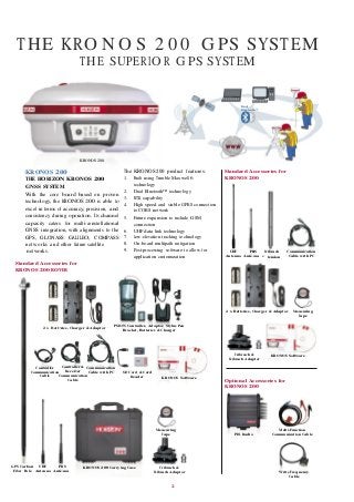
- 1. THE KRO N O S 2 0 0 G PS SYSTEM Ba te PR ten THE SUPERIO R GPS SYSTEM Dual Bluetooth™ PR ten Ex Ba te KRONOS 200 KRONOS 200 THE HORIZON KRONOS 200 GNSS SYSTEM With the core board based on proven technology, the KRONOS 200 is able to excel in terms of accuracy, precision, and consistency during operation. Its channel capacity caters for multi-constellational GNSS integration, with alignments to the GPS, GLONASS GALILEO, COMPASS networks and other future satellite The KRONOS 200 product features: 1. Built using Trimble Maxwell 6 technology 2. Dual Bluetooth™ technology 3. RTK capability 4. High speed and stable GPRS connection to CORS network 5. Future expansion to include GSM connection 6. UHF data link technology 7. Low-elevation tracking technology 8. On-board multipath mitigation Standard Accessories for KRONOS 200 networks. 9. Post-processing software to allow for UHF PRS Tribrach Communication Standard Accessories for KRONOS 200 ROVER application customization Antenna Ante na tension Cable with PC 2 x Batt ries, Charger & Adaptor Measuring Tape 2 x Batt ries, Charger & Adaptor PSION Controller, Adaptor, Stylus Pen Bracket, Batteries & Charger Tribrach & Tribrach Adaptor KRONOS Software Controller Controller & Communication Communication Receiver Cable with PC SD Card & Card Cable Communication Cable Reader KRONOS Software Optional Accessories for KRONOS 200 Measuring Tape PDL Radio Multi-Function Communication Cable GPS Carbon UHF PRS KRONOS 200 Carrying Case Tribrach & Fiber Pole Antenna Ante na Tribrach Adaptor Write Frequency Cable 2
- 2. KRONOS 200 TECHNICAL SPECIFICATIONS GNSS MODULE SPECIFICATIONS: Internal Memory 4G (15 static days with frequency of 1 Hz) Number of Channels 220 Satellite signals tracked GPS: Simultaneous L1 C/A, L2E, L2C, L5 GLONASS: Simultaneous L1 C/A, L1 P, L2 C/A (GLONASS M Only), L2 P SBAS: Simultaneous L1 C/A, L5 GALILEO Simultaneous L1 BOC, E5A, E5B, E5AltBOC1 COMPASS B1,B22-QZSS:L1 C/A, L1 SAIF,L2C, L5 PERFORMANCE SPECIFICATION Initialization time: 45 sec Signal recapture: 1 sec RTK signal initialization 20 sec Velocity Accuracy Horizontal-0.007 m/s Vertical 0.020m/s Acceleration 11 g Maximum Operating Limits Velocity 515m/s Altitude 18,000 m Up to 50 Hz raw measurement & position outputs. Very low noise GNSS carrier phase measurementswith <1 mm precision in a 1 Hz bandwidth Proven low elevation tracking technology. Mother board GSM module The GSM board mount a SIMENS MC75i unit for GSM/GPRS communication. This module supports Single band operation at 800 MHz, Dual band operation at 900 MHz and 1800 MHz, Tri-band operation at 800 MHz, 900 MHz, 1800 MHz. Packet data service of GPRS CLASS 10 Maximum rate of transmission 85.6 kbit/s. Embedded TCP/IP protocol suite that supports multiple links and provides ACK answer and large-capacity cache. Connection devices Connectors I/O: 9-pins serial port (baud rate up to 115.200kbps) and 5-pins LEMO interfaces. Multicable with USB interface for connecting with PC. 2.4GHz Bluetooth device class II Maximum range is 50m. Internal Radio: 3 frequency range option (Emit or Receive) 410-430MHZ, 430-450MHz. 450-470MHZ GSM/GPRS Modem GSM/GPRS data modem maximum range 70km. External radio: PDL radio, emitting power and maximum range depending on model Maximum range 22km. Serial protocols Reference outputs CMR+, CMRx, RTCM 2.1, RTCM 2.3, RTCM 3.0, RTCM 3.1. Navigation outputs: ASCII (NMEA-0183 GSV), AVR, RMC, HDT, VGK, VHD, ROT, GGK, GSA, ZDA, VTG, GST, PJT, PJK, BPQ, GLL, GRS, GBS, GSOF. External cell phone support RTK and VRS operation (optional). Receiver accuracy Static horizontal accuracy 3mm ± 1ppm (RMS). Static vertical accuracy 5mm ± 1ppm (RMS). Fixed RTK horizontal accuracy 8mm ± 1ppm (RMS). Fixed RTK vertical accuracy 15mm ± 1ppm (RMS). DGPS horizontal accuracy 0.25m ± 1ppm (RMS). DGPS vertical accuracy 0.50m ± 1ppm (RMS). Stand Alone RTK positioning accuracy 1.5m (CEP). SBAS horizontal accuracy 0.50m SBAS vertical accuracy 0.85m Power Supply (9 to a 15V DC external power input with over-voltage) Voltage: 7.2 V. Working time in static mode: Typically 6 hours. Working time in RTK rover mode: Typically 4 hours. Charge Time Typically 7 hours. Power consumption < 3.8 W. Remaining time with battery light blinking: 1 hour. Physical specification: Size Height 96mm x Diameter 186mm. 59mm from the center of the rubber loop to the bottom. Weight 1.2 Kg with internal battery, radio standard UHF antenna. Operational temperature - 25°C to 60°C (-13°F to 140°F) Storage temperature - 55°C to 85°C (-67°F to 185°F) Waterproofing Protected from temporary immersion to depth of 1 meter and from 100% humidity and dustproof. Shock resistance Designed to survive a 2m pole drop on the concrete and has vibration resistance.