Bend oregon trail map
•
1 like•3,010 views

Bend, Oregon is a beautiful place to get outdoors! Here is an excellent map depicting the variety of trails Bend, OR has to offer - as well as a collection of local parks to take man's best friend to meet a play mate. If you are considering a real estate purchase, be sure to visit http://www.BendRealEstate.com to view the latest homes for sale w/ local Realtor Greg Broderick or call 541-280-2363 to speak with Greg direct.

Recommended
Recommended
More Related Content
What's hot
Viewers also liked
Similar to Bend oregon trail map
Similar to Bend oregon trail map (20)
Recently uploaded
Recently uploaded (20)
Bend oregon trail map
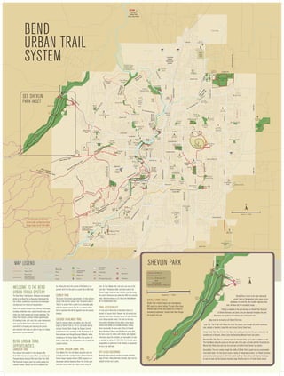
- 1. ắằẳ Tumalo State Park (Day Use Area) Bend Urban Trail System Juniper Ridge Overturf Park SKYLINER RD. D ARIZONA ST. Simpson Site SIMPSON Park Services Center R Private trails, open to public . VE Park & Recreation OA ER IN YL Riverbend District Office Park D ắ AD LO CO Old Mill District Les Schwab Amphitheater ST . H CH AN RD Farewell Bend Park . ắ ắ Cascade Middle School METO Woodriver Park Blakely Park il Central Oregon Canal Trail rT ra R. Bear Creek Elementary Ponderosa ắ Park D ắ Bend Senior Center PURCELL BLVD. te Gardenside Park Larkspur Park Hansen Park ắẳằ . BL VD OO 3RD Hollygrape Park ƽ Approx. 1 Mile FERGUSON RD. RE Jewell Elementary School BEND PARKWA Y River Canyon Park Last boat takeout before Class IV whitewater below ST. KS OO Pine Ridge Elementary Sun Meadow Park D Pine Ridge Park W a Ro hu l rai dT BR ul Ha High Desert Middle School Elk Meadow Elementary Wildflower Park 15TH ST. River Rim Park HAMBY RD. Pinewood Natural Area Foxborough Park sc C POWERS RD. s YD UR T EN Alpine Park For information on US Forest Service Trails, call Bend Fort Rock Ranger Station at 541-383-4000. Kiwanis Park il Tra BEAR CREEK RD. ve e pin Ri l Al Pi Ca lot B na ut l T te ra il REED MKT. ẳắ De h Tet BEND PARKWAY Genna Stadium R. i Tra 20 Coyner Trail WILSON AVE. LIUS D w ero ắằẳ Bend High School Jaycee Park ắ Skyline Park Pilot Butte Park FRANKLIN AVE. ND nd la igh Miller’s Landing McKay Park SK ils l rai sT MT. WASHINGTON DR. de ca s Ca P to US hil’s Trail hea Fores t Ser d: vice Tra Columbia Park Pilot Butte State Park ắ Juniper Park ắ Old Bend Gym ắ Providence Park GREENWOOD BO d Trail en West B Amity Creek School St. Charles Medical Center D HAMBY RD. We GALVESTON n Be Big Sky Park Pilot Butte Middle School Juniper Elementary Juniper Swim & Fitness Center Drake Park WALL ST. st dT Harmon Park Marshall High School Pacific Park Brooks Park Highland School Westside Village School 14TH ST. To USFS Trails Compass Park l rai Summit High School Miller Elementary School Sunset View Park ắ Mt. View Park NEFF RD. OLNEY 9TH ST. NEWPORT High Lakes Elementary School Pioneer Park Al Moody Park Buckingham Elementary AMERICAN LN. PORTLAND ắằ ắ BOND ST. Lewis & Clark Park Orchard Park 27TH ST. D Hillside II Park NW 12TH. Fremont Meadows First St. Rapids Park Ensworth Elementary Hollinshead Park ắD l Hillside I Park Mt. View High School Stover Park 3RD ST. SUMMIT DR. Discovery Trail Riverview Park R Larkspur Trai Summit Park . 3RD ST. COCC & OSU Cascades Campus TON D R Mirada Park 27TH ST. SHING 9TH ST. MT. WA BEND PARKWAY Covered Bridge ER TL BU ET RK MA ắ Pine Nursery Park Canal Row Park D. 15TH ST. Quail Park Deschutes River Trail . 3RD ST. Arch ie Can Briggs yon Trail . RD BEND RIVER PROMENADE RIVER’S EDGE GOLF COURSE Awbrey Village Park Sylvan Park DR K MT .W AS H Shevlin Park PA R GT ON JOHNSON RD. ắ ẳ N ắằ IN LI Sawyer Park Sawyer Uplands Park Lava Ridges Natural Area EMPIRE AVE. . EV YEOMAN RD. D RD SH Ponderosa Elementary EY ắ Boyd Park RIL Aspen Hall Rock Ridge Park Harvest Park . O.B RD. ẳắ ằ tes hu il sc Tra De ver Ri Archie Briggs Canyon Lava Ridge Elementary School Cascade Village Shopping Center (Gopher Gulch: Future Park No Public Access) KIRKALDY CT. (NO PUBLIC PARKING) 97 DESCHUTES MKT. RD. 20 NAM PUT see Shevlin Park inset Sky View Middle School COOLEY Cinder Cone Natural Area High Desert Park KNOTT RD. 97 CH IN Natural Trail Gravel Trail Road Undeveloped Parkland River State Park Canal School Footbridge . Parking BA KE D. Off-Leash Dog Area Mt. Bike Trail Restroom ẳ Loop Trail Tumalo Creek Trail Trailhead The Bend Urban Trails System, developed and managed jointly by the Bend Park & Recreation District and the City of Bend, connects our community and encourages recreation and non-motorized transportation. Trails in the system traverse many different landscapes, including established parks, natural forested areas, and urban areas both sparsely and densely developed. The Urban Trails System currently includes approximately 63 developed miles, with more trails under development each year. The Bend Park & Recreation District is committed to increasing and improving the primary and connector trail routes as rights-of-way and funding opportunities become available. Bend Urban Trail Opportunities LARKSPUR TRAIL The Larkspur Trail extends 4.1 miles between Pilot Butte Middle School and Larkspur Park, passing through Pinewood Natural Area and Pilot Butte State Park. Both Pilot Butte and Larkspur parks have ample parking and restroom facilities. Walkers can add an additional mile by climbing the trail to the summit of Pilot Butte or can proceed north from the park on a paved trail to Neff Road. COYNER TRAIL The Coyner Trail extends approximately 1.4 miles between Juniper Park and the Larkspur Trail. The section west of 15th St. to Juniper Park is paved to an accessible grade, while the segment east of 15th St. is a natural surface trail on easement that will be upgraded once the property develops. CASCADE HIGHLANDS TRAIL Good for mountain bikers and walkers alike, this trail begins at Overturf Park on 17th St. and travels west up and over Overturf Butte through the Skyliner Summit neighborhood to the roundabout at Mt. Washington Dr. It then continues west through Cascade Highlands, before connecting to the Forest Service Phil’s Trail system. 4.6 miles in total length, the trail provides a mix of paved and unpaved surfaces. CENTRAL OREGON CANAL TRAIL From Blakely Park, the trail follows along the west side of Brookswood Blvd. and then heads southwest through Central Oregon Irrigation District (COID) property to an intersection with the Deschutes River Trail. At this point trail users can go either up or down stream along the ắ river. Or, from Blakely Park, trail users can cross to the east side of Brookswood Blvd. and head south to the Central Oregon Canal and take the ditch-road east along the canal to American Lane where the COID trail currently ends. Total trail distance is 3.5 miles from Reed Market Rd. to the Deschutes River. TRAIL ACCESSIBILITY It is the goal of Bend Park & Recreation District to provide trail access for all. However, not all existing trail segments have been evaluated nor are all trails intended to be fully accessible routes. The trails on this map may present obstacles, running slopes, cross slopes, narrow tread widths and unstable surfaces, making them inaccessible for some users. Trails at Farewell Bend, Riverbend, Pioneer and Pine Nursery parks offer the best access for visitors with mobility aids. Updated information about the condition and accessibility of trails is available by calling 541-389-7275. It is the trail user’s responsibility to determine if trail difficulty is appropriate for his or her skill level. PA R K RD Shevlin Parking Lot ẳ ắ Parking ẳ Trailhead ằ Restroom Approx. 1 Mile Covered Bridge Shevlin Park Trails Shevlin Park is Bend’s largest park encompassing 603 acres in a natural setting. The park offers many different types of trails and provides for a variety of recreational experiences. Tumalo Creek flows through the length of the park. Shevlin Park is home to the most diverse old growth forest at this elevation in the region and an abundance of animal life. This includes migratory birds, deer, elk, bear and the occasional cougar. Parking is available at the park entrance on Shevlin Park Road and at Shevlin Commons, and picnic sites are dispersed throughout the park. Restrooms are located at the entrance and at the south end. Dogs must be on-leash on all Shevlin Park trails. Loop Trail: This 6-mile trail follows the rim of the canyon, runs through old growth ponderosa pine, includes a few short, steep hills and crosses Tumalo Creek twice. Fremont Meadows ắằ Tumalo Creek Trail: This 2.5-mile trail follows the creek upstream from the park entrance to the southern end of the park, where it joins the Deschutes National Forest trail system. Mountain Bike Trail: This is a preferred route for mountain bikes, but is open to walkers as well. The trail follows along the canyon on the west side of the park, and links with the Forest Service Mrazek Trail. Riders may also take the east road out to the Forest Service trail system. OFF-LEASH DOG PARKS Bend has seven areas for people to recreate with their dogs off-leash. Unless otherwise indicated, dogs must be leashed on trails and in parks. SH EV LI N ắ Commons Road Footbridge Welcome to the Bend Urban Trails System! Aspen Hall ằắ RR Dam D JOHNSON RD. Park District Boundary Park RD . Road/Sidewalk Trail Connection Road with Bike Lane HA T Shevlin Park Map Legend Paved Trail A To USFS Trails Accessibility: The road running through the middle of Shevlin Park is paved and can accommodate most ability levels. The trail system covers a variety of unimproved surfaces. The Shevlin Commons parking lot provides access to a 0.3-mile asphalt path that allows those with physical challenges to view the park and the Cascade mountain range from the east rim of Tumalo Creek canyon.
- 2. KIRKALDY CT. Cascade Middle School WA S Skyline Ẍ ẗẖSports Park ẳắ DR . Discover the Bend Urban Trails System. PURCELL BLVD. ST . KS OO BR 9TH ST. 3RD il Larkspur Tra SE OU ERH POW N D R N H IXO 15TH ST. DR D N BO R EVL I SH REED ắ Sun Meadow Park ST. KS OO WILSON AVE D Senior Bend Center Pinewood Natural Area ST Larkspur Park ắẳằ MAR KET G RD TRAIL CONTINUES REED M ẋ COID Property Deschutes RE Jewell Elementary School Approx. 1 Mile FERGUSON RD. River flows South to North Road with Bike Lane Natural Trail Road Gravel Trail Canal Road/Sidewalk Trail Connection River Park Undeveloped Parkland . 97 Footbridge Pine Ridge D Off-Leash Dog Area Parking Non-Motorized Boat Launch School BL VD il Tra River s Paved Trail 15TH ST. Map Legend Restroom Dam Park District Boundary Trailhead KNOTT RD. River Hazard ƽ ST. te Ẍ ST. Foxborough Park BL VD OO D Mt. Bachelor Village Trails No Bike Use ND Les Schwab Ampitheater D a Ro ắ Mtn. Bike Route BO Woodriver Park POWERHOUSE LOOP – 1.0 Mi SHORTCUT MILL A LOOP – 1.1 Mi Blakely MILL DISTRICT LOOP 2.4 mi ALTERNATE ROUTE Park . POWERS RD. W l u Ha l rai dT . DR ắ Farewell Bend Park il NT CE Elk Meadow Elementary Wildflower Park Y UR 9TH ST. Central Oregon Canal Trail rT ra ve Ri s te hu sc De Pine Ridge Elementary Park D C CENTENNIAL LOOP 1.33 Mi Cascade Middle School Pine Ridge Park Hollygrape Park C A D R Ponderosa ắ OLUM BIA KiwanisST. Park & Park Rec. District Office REED MKT. Riverbend Park ắằ Woodriver Park Blakely Park HIN MT. GT ON Genna Stadium BEAR CREEK RD. BEND PARKWAY ắ WILSON AVE. MILL TH EA TE Farewell Bend Park ắ D Ẋ ắ ắ ẋ BEND PARKWAY LO CO ST . D RA BO ND MT. WASHINGTON DR. . VE Park & Recreation OA W OO River Rim Park Parks Services Riverbend Park District Office Center Private trails, open to public Private trails, open to public Bear Creek Elementary Coyner ƽTrail SIMP Jaycee SON Park KS ƽ Old Mill District Les Schwab Amphitheater River Canyon Park Last boat takeout before Class IV whitewater below Cinder Cone Natural Area Simpson Site SIMPSON COLORADO ARIZONA McKay Park inset ƽ BEND PARKW AY Look for this symbol along the Deschutes River Trail: South Canyon Reach Ẉ Bend High School ắằẳ DR . The Deschutes River corridor provides for both land and water-based trail opportunities. The water trail allows paddlers to enjoy the river and connect to parks and other destinations along its bank. Access points and boat landings are available at several locations along the water trail. Be aware that the river difficulty changes dramatically from gentle moving ME O LIU is recommended water to Class 4 rapids above the Bill Healy Bridge. Floating the section above the HealyTBridge S DR . only for expert boaters. The Colorado Street, Bend Hydro and Tumalo Irrigation dams require mandatory portaging. il il Tra w Tra ero FLOATING THE RIVER ne eth lpi T A Floating is popular from Riverbend Park at Columbia Street (across from Farewell Bend Park) . to Drake Park on Riverside Blvd. Be cautious. The current is stronger above the Colorado DR RY Street dam than it appears. Watch for the warning signs and U NT exit the river on the left above the Colorado Street CE Alpine il bridge. Floaters must leave the river and portage around the dam. The Tra Park d oa Ride-the-River shuttle operates between these two parks throughout the lR u summer season. For a schedule visit the Cascades East Transit Ha website at cascadeseasttransit.com or call 541-385-8680. For non-motorized boat launch sites, look for the “crossed oars” symbols on the map. McKay Park Old Mill District FRANKLIN AVE. ARIZONA ST. Pilot Butte Park Pilot Butte State Park FF RD WATER TRAIL CH AN Skyline Park ẉ NEFF RD. FRANKLIN A ắ Juniper Park ắ Columbia Park Gym Downtown Bend Amity Creek Magnet School Juniper Swim & Fitness Center Drake ẇ Overturf Park Park Amity Creek Old Bend School Miller’s Landing Marshall High School GREENWOOD ẅ Columbia Park Drakeẇ Park ằ U BL ER LIN as C Y SK igh e H ail d ca Tr MT. WASHINGTON DR. lan ƽ Brooks Park Ẇ Mt. View ắ Mt. Bachelor Village Resort, in partnership with Brooks Resources and the High Pilot Butte Desert Museum, has provided a series of interpretative signs along this section of Juniper Middle Elementary School trail which describe the native habitat, foliage, and other points of interest. OLNEY GALVESTON Pacific Park BOND ST. West B Harmon Park GALVESTON 14TH ST. il end Tra Highland School Westside Village School through neighborhoods and downtown. The trail passes through beautiful Drake Park on Mirror Pond and ends at McKay Park and Colorado Street. Park There are several footbridges along the way offering opportunities to cross the river. Access the trail from any of the adjacent parks. Boat landings il Pioneer Tra at McKay,RDrake, Harmon and Brooks parks provide water trail access. nd ER D. Summit reach SKYLIN Be High School Miller st Elementary OLD MILL REACH We School Once the site of two large ponderosa pine lumber mills, today the Old Mill reach is a mix of river parks, trails and the Shops at the Old Mill District SKYLINER RD (see inset). Trails exist on both sides of the river in addition .to an extensive private trail system throughout the Old Mill District. Three footbridgesD connect trail legs on either side of the river, providing convenient walking loops. On the east side, the trails are paved from the Shops at the Old il Mill District to the upper endst Farewell BendaPark at the Bill Healy Bridge. The trail on the west side offers a mix of paved and unpaved surfaces. of end Tr We B Farewell Bend and Riverbend parks provide boat landings for paddlers usingl the Deschutes River water trail. rai sT nd hla SOUTH CANYON REACH Hig SIMPSON This reach has trail sections on both sides of theariver, connected by a footbridge approximately 1.5 miles upstream of the de c as Farewell Bend Park bridge. The river flows fast here through a beautiful canyon, cascading over rocks and logs. Park il’s Tr ailhe West side: The trail on the west side of C river passes through Mt. Bachelor Village. Bicycles are not allowed on this section of the river trail, Services Mill the ad: rest S Old Center ervic there is an alternative mountain bike route that connects the Bill Healy Bridge to the Haul Road Trail along Century Drive. but T e ra reach ils East side: The east side trail at the northern end of this reach is unpaved, narrow and rocky in places. The trail continues to the South Canyon Footbridge and crosses to the west side to loop back to town. Users can choose to divert up to Brookswood Blvd. on a side trail that originates just upstream of the COID power plant and short timber bridge. At Brookswood, the trail follows the sidewalk through various neighborhoods before reaching Wildflower Park then ultimately River Rim Park. ds Deschutes River Trail NEWPORT ắằ where irrigation water is dropped back to the river Moody turbines, generating Al through two Park electrical power. The public has access to this trail section thanks to an agreement St. Charles Medical Center ẅ with COID—please stay on the designated trail. ằ Harmon Park ắ BR High Lakes Elementary School E PioneerHigh Scho Riverview Stover Park 8 Farewell Bend Park honors the history of the logging industry at this site Park Parkalong the boardwalk explain a riparian with two interpretive signs. Additional signs restoration NEWPORT Ensworth project and other steps being made to care for the healthPacific its of our river and Hollinshead Elementary Brooks Park HighlandOrchard ecosystem. The park includes a playground and restrooms. Park Park9 Magnet School Ẇ The boardwalk here offers a view of Central Oregon Irrigation District’s Hydro site, ắD Park First St. Village Westside Rapids School Magnet Park ắ Pioneer ƽ Park PORTLAND B st Sunset PIONEER REACH We This reach passes through the oldest and most established sections of Bend. The trail isn’t always along the river, sometimes following sidewalksPark View Compass Summit High School Park 7 Across the river from Farewell Bend Park is Riverbend Park, a popular site for events, riverPORTLAND access and picnicking. NEWPORT WALL ST. d en TR R LE UT will be open in summer 2013. riverfront park, it B . Sunset View Park l rai T Pi Ca lot B na ut l T te ra il ẳằ RK D Hillside II Park Discovery This section of river trail is located on the west bank of the river over the Tumalo irrigation canal pipe. Lewis surface is unpaved and relatively The wide trail Trail Clark Park flat. It runs between the river and a high canyon wall, and passes through the River’s Edge golf course and adjacent neighborhoods. A newer section of the trail located on the east bank connects Pioneer Park to Revere Avenue. Boat landings at First Street Rapids Park and Riverview Park provide water trail access. There are several wetlands in this reach, inhabited by songbirds, trumpeter swans, otter and beaver. Osprey frequently nest and fish here. First St. 4 This Drake Park interpretive sign (located directly in front of the public restrooms) Rapids describes Bend’s early sense of community spirit. 5 McKay Park is the site of the Park Railroad. An interpretive sign in the Oregon Trunk Canal MA Hillside I Park RIVER RUN REACH 3 Located across the foot bridge from Drake Park, Pageant Park was named to commemorate the Bend Water Pageant, a favorite community event that ran from 1933-1965. An interpretive sign describes the event highlight, the launch of large, lighted floats on Mirror Pond. AMERICAN LN. Arch ie Can Briggs yon Trail . DR GT ON Trail includes a few moderate hills. Along the middle stretch of this reach, the river drops into a deep canyon, but the trail stays high on the canyon wall, offering spectacular views of the river below and of the Three Sisters in the distance. A steep climb up the Archie Briggs Canyon Trail connects to Mt. High Lakes Washington Drive. Visitors can best access the trail from Sawyer Park. There is limited on-street parking at Sawyer Uplands Park with a connecting ElSchool route down to the river trail. Pine Nurs Park ( 6 the Deschutes River from McKay Park, Miller’s Landing Park was Hillside II ParkaLocated acrossfor the Miller Lumber Company in the)early 1900’s. As the newest holding area River Run reach SUMMIT DR. YEOM 2 The historic Rademacher House and plaza overlook Mirror Pond and Drake Park, with the Three Sisters visible in the background. This site includes a sign interpreting Bend’s founding and early history. park describes Bend’s early railroad history. Row D. MPORTLAND T. WAS HINGT ON DR Summit Park Ponderosa Elementary 1 Sawyer Park offers the opportunity to spot a varietyLava Ridges of birds and wildlife and is ắ EMPIRE AVE. included in the Oregon Cascade Birding Trail system. Natural Area Hillside I Park IN MT .W AS H Lewis Campus COCC Clark OSU Cascades AWBREY REACH West Bend Park This northernmost section of the Deschutes River Trail is constructed on top of the buried Tumalo irrigation canal. It has an unpaved surface and Bridge BE RIV MA Rock RIVER’S EDGE Ridge GOLF Park COURSE Boyd Summit Park . Sylvan Park The Bend Park Recreation District, along with theẳ of BendRand private land owners, is working toward implementing the community’s vision City D. for an uninterrupted river trail. The trail will parallel the Deschutes River running through the heart ofQuailOnce fully completed, the 19 mile trail will Bend. Shevlin Park Park extend from Tumalo State Park to Meadow Camp with further connections to Sunriver. This map shows only existing trails and access points open to public use. The map also shows the river as a water trail and access points to it. Trail users should respect private property and sensitive riparian areas by staying on the trail. The river trail is divided into five reaches, defined by the surrounding landscape character. Covered Ẅ Lava Ridge Elementary School OL OR ADO AVE HI NG RD Awbrey Village Park N ắằ Park Points of Interest Along the Deschutes River Trail 3RD ST. . DR TO N Harvest Park BEND RIVER PROMENADE RIVER’S EDGE GOLF COURSE Sawyer Park MT. WASHINGTON DR. ắằ Ẅ Juniper Ridge Sky View Middle School Village Park Y ILE Sawyer Uplands Park LI ắ Welcome to the DeschutesPARK Trail! River Discover natural landscapes, wildlife, and scenic byways. Discover exceptional places to exercise, cycle, play, relax, or commute. 97 Awbrey Sawyer Park SUMMIT DR. Awbrey Reach EV Sawyer Uplands Park .R tes hu rail sc T De ver Ri KIRKALDY CT. (NO PUBLIC PARKING) RD. SH . Cascade Village Shopping Center COCCArchie Briggs OSU Cascades Canyon Campus ắ DR 3RD ST. D. MR NA PUT B E N D U R B A N TR A I L S M A P 20 (Gopher Gulch: Future Park No Public Access) Aspen Hall IT COOLEY O.B Quail Park NAM PUT JOHNSON RD. MM . MT .W AS D. ON R JOH NS SU ARCHIE BRIGGS RD. 3RD ST. Trail Use Regulations Please help keep the trail experience safe and pleasant for all users: Archie Briggs Canyon Trail RD Deschutes River Trail System ẳắ ằ Please stay on the designated trail. ắằ S ome sections of the trail are on private property. K A reas along the river are sensitive wildlife habitat. Please do not walk along the river bank. PA R M otorized vehicles are not allowed on the trails. N Bicyclists are not allowed on some sections of the trails. Please observe pedestrian-only trail sections. LI C ity ordinances require that dogs must be on leash at all times within the city limits (except at designated off-leash areas) and their waste properly removed. Dog “rest stops” along the trails provide you with disposal bags and trash cans. EV Do not litter. Trash cans are located throughout the park system. No camping, drinking alcohol, smoking or fires allowed. SH Adopt a Pa rk or Trail The Adopt a Trail and Adopt a Park programs give community groups, families and individuals an opportunity to keep our parks and trails beautiful and fun for all. Adopters help with litter clean up, special projects and reporting concerns to the district. For more information on these programs call the Bend Park and Recreation District at 541-389-7275. The Bend Urban Trail System and the Deschutes River Trail are managed by the Bend Park Recreation District. To report trail concerns, call Park Services Dept. at 541-388-5435. After business hours and on weekends call 541-410-3319. © Bend Park and Recreation District, All Rights Reserved, 2013 Hall ẳ FOR FUN, FOR FRIENDS, FOR HEALTH, FOR LIFE!™ D. YR ILE .R O.B Tumalo State Park (Day Use Area) High Pa