Beech Ridge Wind Farm
•Als PPTX, PDF herunterladen•
1 gefällt mir•280 views

The document summarizes a trip taken by Roanoke County planning commissioners and staff to visit the Beech Ridge industrial wind turbine installation in West Virginia. It describes the route taken on the trip and points of interest seen along the way, such as clear-cut ridge tops and a coal transfer station. It provides details about arriving at the Beech Ridge Wind Energy Center and learning about the facility from Invenergy staff, including touring some of the turbines. Concerns are raised about the noise potential of the turbines and their domination of the landscape.

Empfohlen
Weitere ähnliche Inhalte
Ähnlich wie Beech Ridge Wind Farm
Ähnlich wie Beech Ridge Wind Farm (20)
Kürzlich hochgeladen
Kürzlich hochgeladen (20)
Beech Ridge Wind Farm
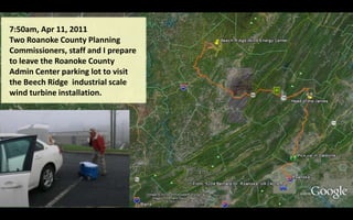
- 1. 7:50am, Apr 11, 2011 Two Roanoke County Planning Commissioners, staff and I prepare to leave the Roanoke County Admin Center parking lot to visit the Beech Ridge industrial scale wind turbine installation.
- 2. Three Roanoke County Planning Commissioners + additional staff load onto the county van at Mill Mountain Coffee & Tea in Daleville.
- 3. As we reach Clifton Forge, we all make note of the landmark rock outcroppings along Route 220 and the Jackson River just North of the Head of the James We then proceed on Interstate 64 West past the paper mill in Covington and speed through the vast stretches of the George Washington National Forest where logging has long been the primary industry. We’ll soon be going by White Sulpher Springs, West Virginia.
- 4. As conscientious land use planners, we must learn to protect the sustainability of our natural environment. The George Washington and Jefferson National Forest cover a broad area of the Appalachian Mountains.
- 5. Ah-h-h, wild & wonderful West Virginia! Look at all those golf courses we missed. And we could have come back and eaten a late afternoon lunch @ The Greenbrier. But no-o, “County’s on a tight budget” Arby’s @Lewisburg
- 6. We continued West past Lewisburg, WV The Arby’s, where we later stopped for lunch was down about there
- 7. Continuing West on the Interstate, we past many clear cut ridge tops, similar to the one on the right; of which, we were completely unaware due to relative elevation difference. As industries have become increasingly mechanized, the impact to our natural environment has multiplied dramatically. The cost of well-managed land restoration has been more expensive than we have been willing to pay for. Poorly “cared-for” lands become “hotbeds” for invasive species and completely disrupt the natural ecosystem. LAND USE PLANNING 2011
- 8. We left I-64 at Sam Black Church and headed North thru Crawley WV to Shawver’s Crossing, where there’s a big, big logging yard.
- 9. Shawver’s Crossing, where the RR track crosses old US Route 60, is on the way to Rupert, WV where we’ll travel northeast toward Beech Knob.
- 10. Rupert, WV Our driver got a little confused as we reached the corner in Rupert as shown below. It’s hard to get lost in Rupert, so we quickly recovered and got on our way out Anjean Road to the northeast.
- 11. Rupert, WV If I remember correctly, Big Clear Creek Church was a landmark that signaled the driver, he was on the correct road. Further along the road, we became aware of the meaning of Big Clear Creek. For about half of this distance on the 16 mile drive to Beech Knob, we traveled along a 30’ - 60’ wide beautiful rushing creek. BIG CLEAR CREEK CHURCH
- 12. Just North of Kessler WV on Anjean Rd we passed by a coal transfer station with a tipple leading back up into the mountain. Below are aerial images of that mining operation over the past 14 years. 1997 2007 From Kessler, a little over 2 miles back we saw very few dwellings. Those that we did see appeared to “hunting cabins.” 2003 2009
- 13. Beech Ridge Wind Energy Center While on the trip, I had little sense of scale. Afterwards, I estimate that we only toured about ¼ of the 10,000 acre installation. This aerial view describe the 16 mile route from Rupert to Beech Knob where we entered the Wind Energy Center
- 14. Discovering Duo, WV (and Cobb & Clearco) While studying the area after our return from the trip I discovered some small unincorporated communities in the hollows around the wind farm. Duo is a small coal camp, that is still inhabited.
- 15. The tiny community of Duo is dominated by nearby wind turbines as close as 3000 feet. The WV Public Service Commission, WV governing authority, conditioned developers to a one mile distance from any opposing residence for the 1.5 MW turbines. 2.5 to 4 MW turbines would require greater distances from residences(Canada & WHO: 2-3 miles) The residents of Duo, Cobb and Clearco agreed prior to the installation. Fortunately, they are predominantly upwind of the closest turbines. Historic Photo of Duo Coal Camp
- 16. Beech Ridge Wind Energy Center, LLC The destination of our field trip. We were welcomed by Supervisor Ed Elswick, Maryellen Goodlatte, Atty., and Invenergy staff. We were told that the current online facility consisted of 67-1.5 MW wind turbines and construction would soon proceed to add 33 more, and likely up to a 186 MW “Nameplate Capacity” their licensed maximum. No current production data is available. Such data is expected to be made available after the project has been fully operational for one full year. The purple path is the on-site tour route.
- 17. Beech Ridge Wind Energy Center, LLC Here we look back at the first two turbines we drove by. One commissioner was equipped with a decibel meter. I didn’t hear him discuss the hertz levels or filters he was using in his measurements. Now that I think about it, I’m not sure if the round cap on the top of it screwed off or not
- 18. Here’s a Google simulation of turbines, JO1 & JO2
- 19. Beech Ridge Wind Energy Center, LLC Near the site of JO3, the first turbine, where we disembarked our vehicles, Invenergy staff describes our location, our relationship to other turbines, and answers to a few questions. The wind speed on this knoll seemed to be between 25 – 30 mph. In this location we heard little other than the sound of the wind.
- 20. The substation seems to have been planned for more capacity. In this area we heard some noise from turbines, the whoosh, whoosh sound as many people describe it. Here again it did not seem something to fear. Yet, to some the area had a harsh ominous feel to it: industrial.
- 21. Here’s a Google simulation of turbines, J01, J02, J03 and the substation
- 22. As we loaded up and travelled on the next stop, several noted the extraordinarily wide clear-cuts for roadways. Invenergy staff recalled their concerns with “choke” points in their path when moving components of the mammoth structures. 2-126’ blades to the truck are moved with one driver in the main cab and an auxiliary driver steering rear wheels, much like a Hook and Ladder truck. Extremely sparse topsoil in restoration areas
- 23. Here’s a Google simulation of one of the turbines on Smokehouse Ridge above Duo, WV
- 24. The next turbine we visited was on Smokehouse Ridge just above the coal camp of Duo, WV Invenergy staff called Chicago to have operators there shut down the turbines we were under for “safety concerns.” Decibel meter readings here provided unimpressive readings
- 25. As we were winding up our tour, we paused and disembarked from our vehicles. We were in a high hollow between 2 ridges. We were approx 1700 feet and 1800 feet from 2 turbines. We were upwind of them and heard no distinct noise from them. Higher up and over 3600 feet away, we heard the constant, regular, whooshing sounds of the blades from 3 other turbines. We were downwind of those and the terrain funneled the sound toward us. I think the Commissioners were just beginning to get an understanding of the nuisance potential of the noise as we were leaving. That’s a workman on top of that nacelle over 3600 feet away from us.
- 26. As we left our hosts, all noticed a gateway to a neighbor’s property with some ominous looking icons higher up the hill. The turbines dominate the landscape and enough variables are involved that conditions will occur where sound, shadow flicker and environmental domination render such installations to be a significant nuisance and imposition upon residents’ lives, prohibiting them from continuing the peaceful enjoyment of their property. Setbacks from non-participating property lines must be a factor of turbine size. For protection of Roanoke County citizens; 3500’ of setback per 1MW of name plate capacity should be an absolute minimum standard based upon current wind turbine technology. Any reduction of setback should only be through a judicially oriented variance process.